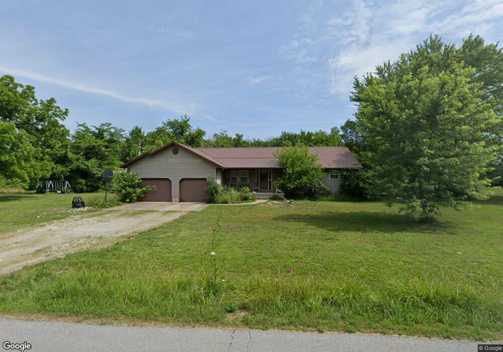
127 Hayes Rd Buffalo, MO 65622
Estimated Value: $239,072 - $278,000
--
Bed
--
Bath
1,740
Sq Ft
$146/Sq Ft
Est. Value
About This Home
This home is located at 127 Hayes Rd, Buffalo, MO 65622 and is currently estimated at $254,024, approximately $145 per square foot. 127 Hayes Rd is a home with nearby schools including Buffalo High School.
Ownership History
Date
Name
Owned For
Owner Type
Purchase Details
Closed on
Jul 1, 2024
Sold by
Turner Stephanie and Turner David
Bought by
Turner Stephanie and Turner David
Current Estimated Value
Home Financials for this Owner
Home Financials are based on the most recent Mortgage that was taken out on this home.
Original Mortgage
$275,000
Outstanding Balance
$272,462
Interest Rate
7.03%
Mortgage Type
New Conventional
Estimated Equity
-$18,438
Purchase Details
Closed on
Oct 23, 2023
Sold by
Canon Allen
Bought by
Turner Stephanie and Turner David
Create a Home Valuation Report for This Property
The Home Valuation Report is an in-depth analysis detailing your home's value as well as a comparison with similar homes in the area
Home Values in the Area
Average Home Value in this Area
Purchase History
| Date | Buyer | Sale Price | Title Company |
|---|---|---|---|
| Turner Stephanie | -- | None Listed On Document | |
| Turner Stephanie | -- | None Listed On Document | |
| Turner Stephanie | -- | None Listed On Document |
Source: Public Records
Mortgage History
| Date | Status | Borrower | Loan Amount |
|---|---|---|---|
| Open | Turner Stephanie | $275,000 |
Source: Public Records
Tax History Compared to Growth
Tax History
| Year | Tax Paid | Tax Assessment Tax Assessment Total Assessment is a certain percentage of the fair market value that is determined by local assessors to be the total taxable value of land and additions on the property. | Land | Improvement |
|---|---|---|---|---|
| 2024 | $1,061 | $25,770 | $0 | $0 |
| 2023 | $1,049 | $23,660 | $0 | $0 |
| 2022 | $1,009 | $24,720 | $0 | $0 |
| 2021 | $1,010 | $22,560 | $0 | $0 |
| 2020 | $1,008 | $22,560 | $0 | $0 |
| 2019 | $1,010 | $22,560 | $0 | $0 |
| 2018 | $883 | $22,560 | $0 | $0 |
| 2017 | $883 | $22,180 | $0 | $0 |
| 2016 | $821 | $22,630 | $0 | $0 |
| 2015 | -- | $20,590 | $0 | $0 |
| 2014 | -- | $20,590 | $0 | $0 |
Source: Public Records
Map
Nearby Homes
- 244 Hayes Rd
- 000 Lot 1 Wicker St
- 000 Wicker St
- 0 Wicker St Unit 3 MAR24033047
- 1004 Dogwood St
- 108 Prince St
- 744 Oak St
- 402 Woodland
- 502 S Maple St
- 000 State Highway 32
- 419 S Cedar St
- 316 S Maple St
- 712 Fir St
- 755 E Main St
- 412 E Benton St
- 305 W Main St
- 000 Mill St
- 117 W Madison St
- 000 Brokenbow Rd
- 000 W Dallas St
- 132 Hayes Rd
- 133 Hayes Rd
- 120 Hayes Rd
- 140 Hayes Rd
- 123 Hayes Rd
- 112 Hayes Rd
- 148 Hayes Rd
- 99 Hayes Rd
- 159 Hayes Rd
- 20 Clark
- 92 Hayes Rd
- 91 Hayes Rd
- 162 Hayes Rd
- 1173 Us 65 Hwy
- 0 Vintage Unit 60007190
- 0 Wildwood Unit 10801914
- 0 E Parcel Unit 10812997
- 0 W Parcel Unit 10812894
- 0 E Parcel Unit 10812993
- 0 Birch & Cooper Unit 10904873