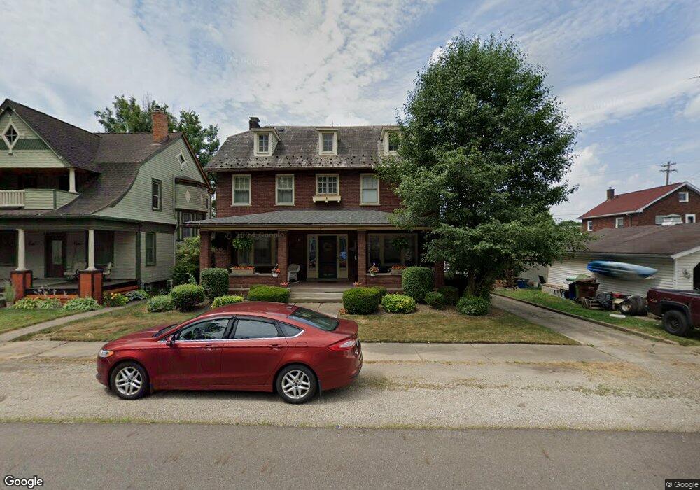
127 High St SE Canal Fulton, OH 44614
Estimated Value: $181,000 - $242,125
3
Beds
2
Baths
2,190
Sq Ft
$99/Sq Ft
Est. Value
About This Home
This home is located at 127 High St SE, Canal Fulton, OH 44614 and is currently estimated at $216,531, approximately $98 per square foot. 127 High St SE is a home located in Stark County with nearby schools including W.S. Stinson Elementary School, Northwest Primary School, and Northwest Middle School.
Ownership History
Date
Name
Owned For
Owner Type
Purchase Details
Closed on
Jul 28, 1997
Sold by
Miller Herbert L
Bought by
Hayes Gregory J and Hayes Sandra
Current Estimated Value
Home Financials for this Owner
Home Financials are based on the most recent Mortgage that was taken out on this home.
Original Mortgage
$119,200
Outstanding Balance
$18,292
Interest Rate
7.81%
Mortgage Type
New Conventional
Estimated Equity
$198,239
Purchase Details
Closed on
Aug 31, 1990
Create a Home Valuation Report for This Property
The Home Valuation Report is an in-depth analysis detailing your home's value as well as a comparison with similar homes in the area
Home Values in the Area
Average Home Value in this Area
Purchase History
| Date | Buyer | Sale Price | Title Company |
|---|---|---|---|
| Hayes Gregory J | $149,000 | -- | |
| -- | $83,000 | -- |
Source: Public Records
Mortgage History
| Date | Status | Borrower | Loan Amount |
|---|---|---|---|
| Open | Hayes Gregory J | $119,200 |
Source: Public Records
Tax History Compared to Growth
Tax History
| Year | Tax Paid | Tax Assessment Tax Assessment Total Assessment is a certain percentage of the fair market value that is determined by local assessors to be the total taxable value of land and additions on the property. | Land | Improvement |
|---|---|---|---|---|
| 2025 | -- | $55,160 | $13,650 | $41,510 |
| 2024 | -- | $55,160 | $13,650 | $41,510 |
| 2023 | $1,349 | $44,280 | $10,190 | $34,090 |
| 2022 | $1,379 | $44,280 | $10,190 | $34,090 |
| 2021 | $1,383 | $44,280 | $10,190 | $34,090 |
| 2020 | $1,114 | $35,670 | $7,880 | $27,790 |
| 2019 | $1,127 | $35,680 | $7,880 | $27,800 |
| 2018 | $1,154 | $35,680 | $7,880 | $27,800 |
| 2017 | $1,061 | $32,460 | $6,970 | $25,490 |
| 2016 | $1,072 | $32,460 | $6,970 | $25,490 |
| 2015 | $1,025 | $31,860 | $6,970 | $24,890 |
| 2014 | $1,008 | $29,970 | $6,550 | $23,420 |
| 2013 | $510 | $29,970 | $6,550 | $23,420 |
Source: Public Records
Map
Nearby Homes
- 156 Cherry St W
- 316 Locust St N
- 752 Poplar St
- 542 E Lakewood Dr
- S/L 32 Lakewood Dr E
- S/L 27 Lakewood Dr E
- 539 E Lakewood Dr
- 537 E Lakewood Dr
- 7985 Leaver Ave NW
- 760 Longview Ave
- 797 Goodland Cir NW
- 8055 Erie Ave NW
- Ballenger w/ Basement Plan at Heritage Village
- Columbia w/ Basement Plan at Heritage Village
- Allegheny w/ Basement Plan at Heritage Village
- Hudson w/ Basement Plan at Heritage Village
- 8089 Erie Ave NW
- 8113 Erie Ave NW
- 912 Tamwood Dr
- 1808 Pauli St
- 135 High St SE
- 147 Cherry St E
- 159 Cherry St E
- 207 Cherry St E
- 215 High St SE
- 128 High St SE
- 215 Cherry St E
- 449 Emerald Bay Ave NW
- 208 High St SE
- 122 Cherry St E
- 235 High St SE
- 206 Cherry St E
- 118 Walnut Ave
- 232 High St SE
- 218 Cherry St E
- 240 Poplar St
- 235 Cherry St E
- 110 N Canal St
- 230 Cherry St E
- 139 Market St E