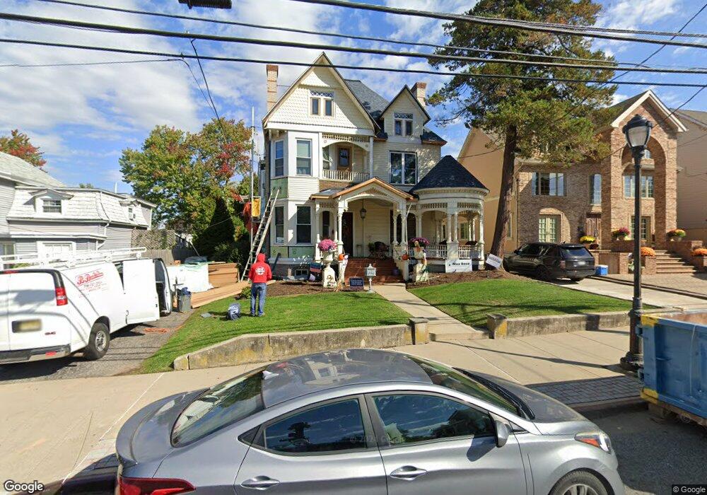
127 Main St Staten Island, NY 10307
Tottenville NeighborhoodEstimated Value: $1,517,000 - $1,754,000
--
Bed
4
Baths
5,047
Sq Ft
$322/Sq Ft
Est. Value
About This Home
This home is located at 127 Main St, Staten Island, NY 10307 and is currently estimated at $1,626,193, approximately $322 per square foot. 127 Main St is a home located in Richmond County with nearby schools including P.S. 1 Tottenville, Is 34 Tottenville, and Tottenville High School.
Ownership History
Date
Name
Owned For
Owner Type
Purchase Details
Closed on
Feb 21, 2025
Sold by
Klages Dennis F and Klages Joanne G
Bought by
Dennis F Klages And Joanne G Klages Irrevocab and Klages-Bombich
Current Estimated Value
Create a Home Valuation Report for This Property
The Home Valuation Report is an in-depth analysis detailing your home's value as well as a comparison with similar homes in the area
Home Values in the Area
Average Home Value in this Area
Purchase History
| Date | Buyer | Sale Price | Title Company |
|---|---|---|---|
| Dennis F Klages And Joanne G Klages Irrevocab | -- | Accurate Land Abstract |
Source: Public Records
Tax History Compared to Growth
Tax History
| Year | Tax Paid | Tax Assessment Tax Assessment Total Assessment is a certain percentage of the fair market value that is determined by local assessors to be the total taxable value of land and additions on the property. | Land | Improvement |
|---|---|---|---|---|
| 2025 | $11,036 | $94,440 | $12,189 | $82,251 |
| 2024 | $11,048 | $79,380 | $13,756 | $65,624 |
| 2023 | $9,465 | $48,005 | $12,586 | $35,419 |
| 2022 | $8,754 | $60,120 | $19,380 | $40,740 |
| 2021 | $9,228 | $56,880 | $19,380 | $37,500 |
| 2020 | $9,218 | $62,880 | $19,380 | $43,500 |
| 2019 | $8,578 | $59,340 | $19,380 | $39,960 |
| 2018 | $7,857 | $40,004 | $18,380 | $21,624 |
| 2017 | $7,394 | $37,740 | $19,380 | $18,360 |
| 2016 | $7,499 | $39,060 | $19,380 | $19,680 |
| 2015 | $6,858 | $39,000 | $16,140 | $22,860 |
| 2014 | $6,858 | $37,324 | $15,911 | $21,413 |
Source: Public Records
Map
Nearby Homes
- 112 Johnson Ave
- 141 Butler Ave
- 133 Butler Ave
- 137 Butler Ave
- 5362 Arthur Kill Rd
- 5463 Arthur Kill Rd Unit 5465
- 5463-5465 Arthur Kill Rd
- 42 Girard St
- 151 Bentley St
- 155 Bentley St
- 146 Bentley St
- 162 Bentley St
- 7546 Amboy Rd
- 147 Wood Ave
- 5265 Arthur Kill Rd
- 397 Ellis St
- 7372 Amboy Rd
- 133 Fisher Ave
- 131 Hopping Ave
- 217-219 Fisher Ave
- 133 Main St
- 121 Main St
- 141D Main St
- 137A Main St
- 141C Main St
- 137 Main St
- 115 Main St
- 141B Main St
- 139A Main St
- 141A Main St
- 141 Main St Unit A
- 141 Main St Unit 1
- 141 Main St Unit B
- 141 Main St
- 141 Main St Unit D
- 124 Tyrrell St
- 126 Tyrrell St
- 126 Tyrrell St Unit Building
- 122 Tyrrell St
- 128 Tyrrell St