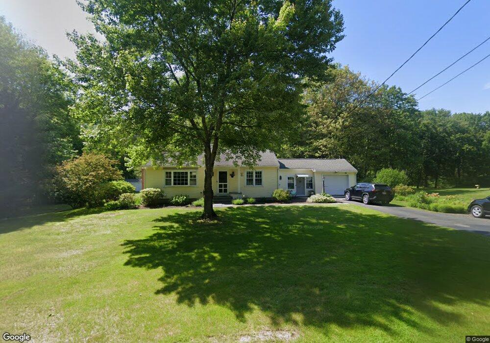
127 Mountain Rd Holyoke, MA 01040
Estimated Value: $317,078 - $347,000
2
Beds
1
Bath
1,140
Sq Ft
$288/Sq Ft
Est. Value
About This Home
This home is located at 127 Mountain Rd, Holyoke, MA 01040 and is currently estimated at $328,020, approximately $287 per square foot. 127 Mountain Rd is a home located in Hampden County with nearby schools including Harriet Bishop Elementary School, Lt. Clayre Sullivan Elementary School, and Holyoke High School.
Ownership History
Date
Name
Owned For
Owner Type
Purchase Details
Closed on
Sep 10, 2004
Sold by
Wheatley Robert R
Bought by
Hentnick Glen A and Taylor Katie L
Current Estimated Value
Home Financials for this Owner
Home Financials are based on the most recent Mortgage that was taken out on this home.
Original Mortgage
$149,600
Outstanding Balance
$75,103
Interest Rate
6.08%
Mortgage Type
Purchase Money Mortgage
Estimated Equity
$252,917
Purchase Details
Closed on
Feb 27, 2003
Sold by
Mackos Dorothy W
Bought by
Mackos Dorothy W and Wheatley Robert R
Purchase Details
Closed on
Oct 30, 1987
Sold by
Grici Donald
Bought by
Doukellis Peter
Home Financials for this Owner
Home Financials are based on the most recent Mortgage that was taken out on this home.
Original Mortgage
$200,000
Interest Rate
10.97%
Mortgage Type
Purchase Money Mortgage
Create a Home Valuation Report for This Property
The Home Valuation Report is an in-depth analysis detailing your home's value as well as a comparison with similar homes in the area
Home Values in the Area
Average Home Value in this Area
Purchase History
| Date | Buyer | Sale Price | Title Company |
|---|---|---|---|
| Hentnick Glen A | $187,000 | -- | |
| Mackos Dorothy W | -- | -- | |
| Doukellis Peter | $255,000 | -- |
Source: Public Records
Mortgage History
| Date | Status | Borrower | Loan Amount |
|---|---|---|---|
| Open | Hentnick Glen A | $149,600 | |
| Previous Owner | Doukellis Peter | $200,000 |
Source: Public Records
Tax History Compared to Growth
Tax History
| Year | Tax Paid | Tax Assessment Tax Assessment Total Assessment is a certain percentage of the fair market value that is determined by local assessors to be the total taxable value of land and additions on the property. | Land | Improvement |
|---|---|---|---|---|
| 2025 | $4,185 | $239,700 | $73,200 | $166,500 |
| 2024 | $3,953 | $208,600 | $69,700 | $138,900 |
| 2023 | $3,773 | $201,100 | $69,700 | $131,400 |
| 2022 | $3,657 | $189,900 | $69,700 | $120,200 |
| 2021 | $3,528 | $183,100 | $66,700 | $116,400 |
| 2020 | $3,368 | $176,500 | $66,700 | $109,800 |
| 2019 | $5,460 | $172,800 | $66,700 | $106,100 |
| 2018 | $3,200 | $167,300 | $66,700 | $100,600 |
| 2017 | $4,779 | $167,300 | $66,700 | $100,600 |
| 2016 | $3,220 | $168,400 | $68,900 | $99,500 |
| 2015 | $3,206 | $168,400 | $68,900 | $99,500 |
Source: Public Records
Map
Nearby Homes
- 7 Western View Rd
- 56 Pomeroy St
- 59 Campbell Dr
- 89 Jarvis Ave
- 23 Scott Hollow Dr
- 6 Emily Ln
- 4 Coed Dr
- 405 Rock Valley Rd
- 33 Maple Crest Cir Unit D
- 15 Maple Crest Cir Unit D
- 34 Maple Crest Cir Unit B
- 36 County Rd
- 55 Longfellow Rd
- 11 Longfellow Rd
- 102 W Meadowview Rd
- 4 Claren Dr
- 14 Eastwood Dr
- 13 Golden Dr
- 22 Eastwood Ln
- 37 Laura Ln
- 119 Mountain Rd
- 130 Mountain Rd
- 135 Mountain Rd
- 111 Mountain Rd
- 136 Mountain Rd
- 140 Mountain Rd
- 155 Cross Rd
- 203 Mountain Rd
- 136 Cross Rd
- 687 W Cherry St
- 687 W Cherry St Unit 1
- 693 W Cherry St
- 103 Mountain Rd
- 683 W Cherry St
- 145 Cross Rd
- 209 Mountain Rd
- 679 W Cherry St
- 100 Mountain Rd
- 673 W Cherry St
- 667 W Cherry St