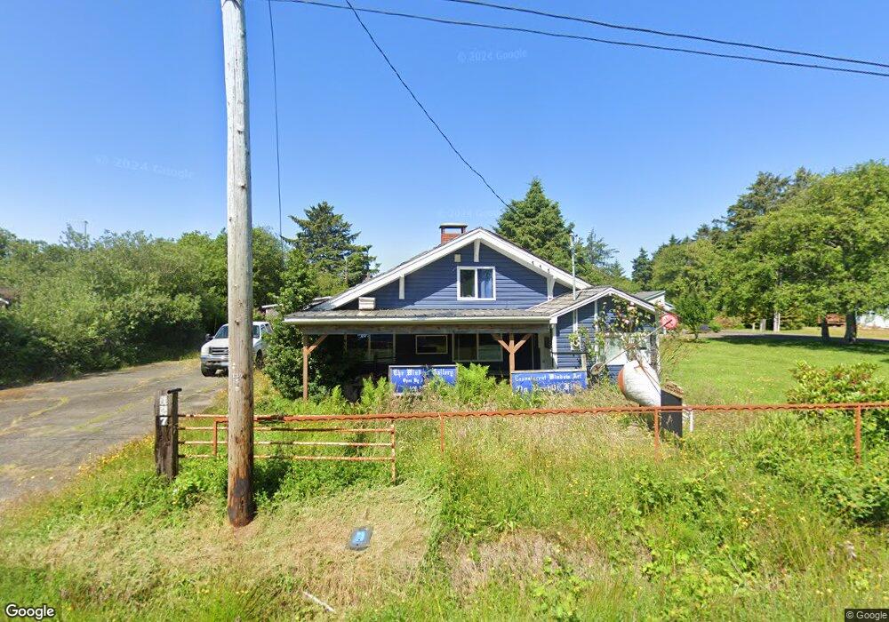
127 N 1st St Pacific Beach, WA 98571
Pacific Beach NeighborhoodEstimated Value: $278,000 - $612,000
3
Beds
1
Bath
1,495
Sq Ft
$303/Sq Ft
Est. Value
About This Home
This home is located at 127 N 1st St, Pacific Beach, WA 98571 and is currently estimated at $452,333, approximately $302 per square foot. 127 N 1st St is a home located in Grays Harbor County with nearby schools including North Beach Junior/Senior High School.
Ownership History
Date
Name
Owned For
Owner Type
Purchase Details
Closed on
Apr 17, 2018
Sold by
Welliever Don
Bought by
Darrah Gary S and Darrah Beverly
Current Estimated Value
Purchase Details
Closed on
Mar 15, 2016
Sold by
Darrah Gary S and Darrah Beverly
Bought by
Welliever Don
Home Financials for this Owner
Home Financials are based on the most recent Mortgage that was taken out on this home.
Original Mortgage
$61,000
Interest Rate
3.72%
Mortgage Type
Seller Take Back
Create a Home Valuation Report for This Property
The Home Valuation Report is an in-depth analysis detailing your home's value as well as a comparison with similar homes in the area
Home Values in the Area
Average Home Value in this Area
Purchase History
| Date | Buyer | Sale Price | Title Company |
|---|---|---|---|
| Darrah Gary S | $80,111 | None Available | |
| Welliever Don | $66,000 | Gh Title |
Source: Public Records
Mortgage History
| Date | Status | Borrower | Loan Amount |
|---|---|---|---|
| Previous Owner | Welliever Don | $61,000 |
Source: Public Records
Tax History Compared to Growth
Tax History
| Year | Tax Paid | Tax Assessment Tax Assessment Total Assessment is a certain percentage of the fair market value that is determined by local assessors to be the total taxable value of land and additions on the property. | Land | Improvement |
|---|---|---|---|---|
| 2025 | $2,166 | $310,313 | $99,000 | $211,313 |
| 2023 | $1,383 | $191,812 | $91,350 | $100,462 |
| 2022 | $1,313 | $146,888 | $63,000 | $83,888 |
| 2021 | $1,065 | $146,888 | $63,000 | $83,888 |
| 2020 | $1,086 | $107,711 | $45,000 | $62,711 |
| 2019 | $989 | $107,711 | $45,000 | $62,711 |
| 2018 | $1,011 | $98,016 | $45,000 | $53,016 |
| 2017 | $482 | $94,089 | $45,000 | $49,089 |
| 2016 | $483 | $46,555 | $35,000 | $11,555 |
| 2014 | -- | $47,470 | $35,000 | $12,470 |
| 2013 | -- | $48,005 | $35,000 | $13,005 |
Source: Public Records
Map
Nearby Homes
- 4 Drake Ln
- 102 N First St
- 100 1st St N
- 3936 Washington 109
- 3910 Washington 109
- 4592 Washington 109
- 33 Butterfly Ln
- 39 Paradise Ln
- 4128 Washington 109
- 44 Robin Ln
- 42 N First
- 56 Butterfly Ln
- 55 Paradise Ln
- 4631 State Route 109
- 18 2nd St
- 19 N 3rd St
- 0 Railroad Ave
- 34 Main St
- 0 Sunset St Unit NWM2373379
- 3183 Ocean Beach Rd
- 127 N First St
- 127 1st St N
- 119 1st St N
- 67 Patterson St
- 99 1st St N
- 17 Drake Ln
- 11 Drake Ln
- 122 N 1st St
- 64 Patterson St
- 5 Drake Ln
- 3 Darien Ln
- 4560 State Route 109
- 4570 State Route 109
- 133 N First St
- 0 Moclips River Unit 29126708
- 0 Moclips River Unit 42584
- 5 C- Block 1 St
- 0 Moclips River Unit 29126693
- 2134 Xxxx