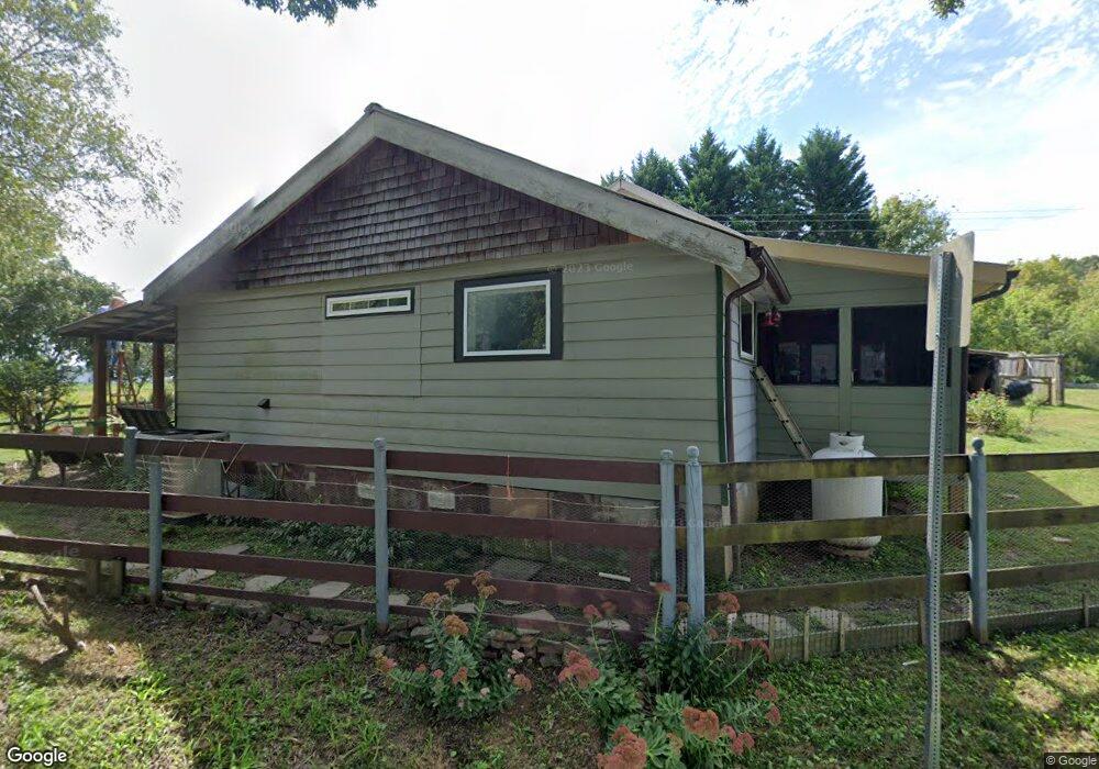
127 Partin Rd Cleveland, GA 30528
Estimated Value: $122,000 - $258,000
3
Beds
2
Baths
942
Sq Ft
$212/Sq Ft
Est. Value
About This Home
This home is located at 127 Partin Rd, Cleveland, GA 30528 and is currently estimated at $200,099, approximately $212 per square foot. 127 Partin Rd is a home located in White County with nearby schools including Mossy Creek Elementary School, White County 9th Grade Academy, and White County Middle School.
Ownership History
Date
Name
Owned For
Owner Type
Purchase Details
Closed on
Apr 16, 2024
Sold by
Arrowood Charles
Bought by
Arrowood Laura
Current Estimated Value
Purchase Details
Closed on
Aug 1, 2006
Sold by
Not Provided
Bought by
Arrowood Laura and Arrowood Charles
Home Financials for this Owner
Home Financials are based on the most recent Mortgage that was taken out on this home.
Original Mortgage
$102,400
Interest Rate
6.73%
Mortgage Type
New Conventional
Create a Home Valuation Report for This Property
The Home Valuation Report is an in-depth analysis detailing your home's value as well as a comparison with similar homes in the area
Home Values in the Area
Average Home Value in this Area
Purchase History
| Date | Buyer | Sale Price | Title Company |
|---|---|---|---|
| Arrowood Laura | -- | -- | |
| Arrowood Laura | -- | -- |
Source: Public Records
Mortgage History
| Date | Status | Borrower | Loan Amount |
|---|---|---|---|
| Previous Owner | Arrowood Laura | $102,400 |
Source: Public Records
Tax History Compared to Growth
Tax History
| Year | Tax Paid | Tax Assessment Tax Assessment Total Assessment is a certain percentage of the fair market value that is determined by local assessors to be the total taxable value of land and additions on the property. | Land | Improvement |
|---|---|---|---|---|
| 2025 | $736 | $43,356 | $8,316 | $35,040 |
| 2024 | $736 | $43,356 | $8,316 | $35,040 |
| 2023 | $323 | $38,620 | $7,392 | $31,228 |
| 2022 | $658 | $32,788 | $6,932 | $25,856 |
| 2021 | $622 | $25,184 | $5,420 | $19,764 |
| 2020 | $554 | $21,680 | $5,032 | $16,648 |
| 2019 | $556 | $21,680 | $5,032 | $16,648 |
| 2018 | $556 | $21,680 | $5,032 | $16,648 |
| 2017 | $441 | $17,764 | $5,032 | $12,732 |
| 2016 | $242 | $10,636 | $5,032 | $5,604 |
| 2015 | $231 | $26,590 | $5,032 | $5,604 |
| 2014 | $223 | $25,840 | $0 | $0 |
Source: Public Records
Map
Nearby Homes
- 0 Partin Rd Unit LOT 1 10539978
- 00 Partin Rd
- 279 Leisure Acres Dr
- 283 Leisure Acres Dr
- 16 Bear Lovers Ct
- 28 Bear Lovers Ct
- 57 Autumnwood Way
- 2523 Westmoreland Rd
- 489 Asbury Mill Rd
- 640 Collins Rd
- 333 Song Bird Dr
- 229 Samson Way
- 705 & 0 Long Mountain Rd
- 705 Long Mountain Rd
- 705 & Long Mountain Rd
- 250 Truelove Rd
- 1839 Westmoreland Rd
- LOT 28 Long Mountain Rd
- 5282 Highway 129 S
- 59 Rocket Dr
- 122 Partin Rd
- 10 Lawson Rd
- 191 Partin Rd
- 0 Mobile Home Dr
- 66 Mobile Home Dr
- 223 Partin Rd
- 223 Partin Rd
- 161 Mary Ellen Dr
- 0 Partin Rd Unit 7318668
- 0 Partin Rd Unit 7220782
- 0 Partin Rd Unit 10162540
- 0 Partin Rd Unit 20075773
- 0 Partin Rd Unit 20068475
- 0 Partin Rd Unit 20060338
- 0 Partin Rd Unit 20051807
- 0 Partin Rd Unit 20043314
- 0 Partin Rd Unit 20034806
- 0 Partin Rd Unit 20027194
- 0 Partin Rd Unit 20020283
- 0 Partin Rd Unit 20012841