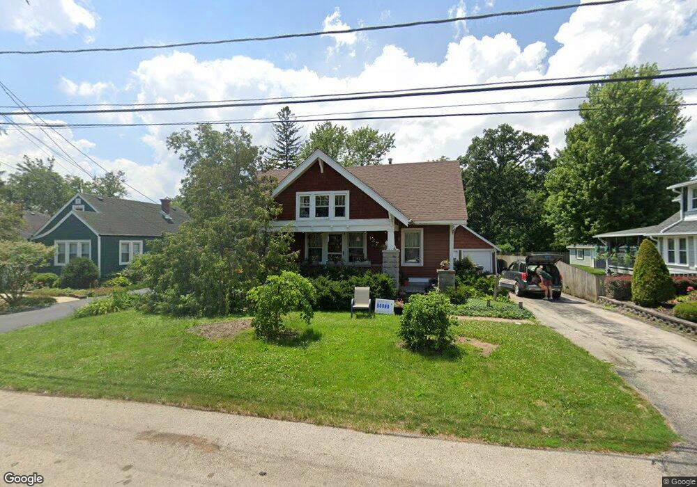
127 S Pine St New Lenox, IL 60451
Estimated Value: $309,000 - $390,000
Studio
--
Bath
--
Sq Ft
8,276
Sq Ft Lot Lot
About This Home
This home is located at 127 S Pine St, New Lenox, IL 60451 and is currently estimated at $344,194. 127 S Pine St is a home located in Will County with nearby schools including Bentley Elementary School, Arnold J Tyler School, and Alex M Martino Jr High School.
Ownership History
Date
Name
Owned For
Owner Type
Purchase Details
Closed on
May 5, 2025
Sold by
Gaier Lisa A and Gaier Mark A
Bought by
Mark A Gaier And Lisa A Gaier Joint Trust and Gaier
Current Estimated Value
Purchase Details
Closed on
Jul 1, 1994
Sold by
Manheim Chris J and Elliott Manheim Wendy M
Bought by
Gaier Mark A and Gaier Lisa A
Home Financials for this Owner
Home Financials are based on the most recent Mortgage that was taken out on this home.
Original Mortgage
$121,600
Interest Rate
8.66%
Create a Home Valuation Report for This Property
The Home Valuation Report is an in-depth analysis detailing your home's value as well as a comparison with similar homes in the area
Home Values in the Area
Average Home Value in this Area
Purchase History
We collect this data history from publicly available records. To have your information removed, we recommend requesting removal directly through your county’s website.
| Date | Buyer | Sale Price | Title Company |
|---|---|---|---|
| Mark A Gaier And Lisa A Gaier Joint Trust | -- | None Listed On Document | |
| Gaier Mark A | $152,000 | Chicago Title Insurance Co |
Source: Public Records
Mortgage History
We collect this data history from publicly available records. To have your information removed, we recommend requesting removal directly through your county’s website.
| Date | Status | Borrower | Loan Amount |
|---|---|---|---|
| Previous Owner | Gaier Mark A | $121,600 |
Source: Public Records
Tax History
| Year | Tax Paid | Tax Assessment Tax Assessment Total Assessment is a certain percentage of the fair market value that is determined by local assessors to be the total taxable value of land and additions on the property. | Land | Improvement |
|---|---|---|---|---|
| 2024 | $8,729 | $111,109 | $22,770 | $88,339 |
| 2023 | $8,368 | $101,285 | $20,757 | $80,528 |
| 2022 | $7,554 | $93,307 | $19,122 | $74,185 |
| 2021 | $7,165 | $87,753 | $17,984 | $69,769 |
| 2020 | $6,957 | $84,622 | $17,342 | $67,280 |
| 2019 | $6,655 | $81,998 | $16,804 | $65,194 |
| 2018 | $6,498 | $79,172 | $16,225 | $62,947 |
| 2017 | $6,171 | $76,896 | $15,759 | $61,137 |
| 2016 | $5,987 | $74,838 | $15,337 | $59,501 |
| 2015 | $5,764 | $72,482 | $14,854 | $57,628 |
| 2014 | $5,764 | $71,588 | $14,671 | $56,917 |
| 2013 | $5,764 | $72,553 | $14,869 | $57,684 |
Source: Public Records
Map
Nearby Homes
- 324 Gina Dr Unit 2
- 144 E 2nd Ave
- 601 Ogden Rd
- 289 Osage Ln
- 1787 Lakes Park Dr
- 3126 Timberlake Ave
- 1777 Lakes Park Dr
- 3171 Waterwood Ln
- Lot 1 Jacks Trail
- 309 Osage Ln
- 2970 Timberlake Ave
- 1750 Lakes Park Dr
- 3000 Timberlake Ave
- 3003 Timberlake Ave
- 2930 Amaranth Ct
- 270 Osage Ln
- 3024 Timberlake Ave
- 1771 Lakes Park Dr
- 250 Teerling Cir
- 2600 Delavan Dr
Your Personal Tour Guide
Ask me questions while you tour the home.