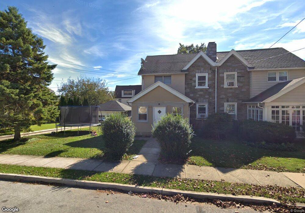
127 Summit Ave Upper Darby, PA 19082
Estimated Value: $307,000 - $395,000
3
Beds
2
Baths
2,166
Sq Ft
$156/Sq Ft
Est. Value
About This Home
This home is located at 127 Summit Ave, Upper Darby, PA 19082 and is currently estimated at $336,828, approximately $155 per square foot. 127 Summit Ave is a home located in Delaware County with nearby schools including Upper Darby Kdg Center, Drexel Hill Middle School, and Upper Darby High School.
Ownership History
Date
Name
Owned For
Owner Type
Purchase Details
Closed on
Nov 22, 2011
Sold by
Tolomea Frances D
Bought by
Montesdeoca Fermin and Montesdeoca Rosa A Campoverde
Current Estimated Value
Home Financials for this Owner
Home Financials are based on the most recent Mortgage that was taken out on this home.
Original Mortgage
$103,020
Interest Rate
4%
Mortgage Type
FHA
Purchase Details
Closed on
Sep 26, 2003
Sold by
Tronca Gloria
Bought by
Tronca Gloria
Create a Home Valuation Report for This Property
The Home Valuation Report is an in-depth analysis detailing your home's value as well as a comparison with similar homes in the area
Home Values in the Area
Average Home Value in this Area
Purchase History
| Date | Buyer | Sale Price | Title Company |
|---|---|---|---|
| Montesdeoca Fermin | $120,000 | None Available | |
| Tronca Gloria | -- | -- |
Source: Public Records
Mortgage History
| Date | Status | Borrower | Loan Amount |
|---|---|---|---|
| Previous Owner | Montesdeoca Fermin | $103,020 |
Source: Public Records
Tax History
| Year | Tax Paid | Tax Assessment Tax Assessment Total Assessment is a certain percentage of the fair market value that is determined by local assessors to be the total taxable value of land and additions on the property. | Land | Improvement |
|---|---|---|---|---|
| 2025 | $5,956 | $140,830 | $39,500 | $101,330 |
| 2024 | $5,956 | $140,830 | $39,500 | $101,330 |
| 2023 | $5,900 | $140,830 | $39,500 | $101,330 |
| 2022 | $5,741 | $140,830 | $39,500 | $101,330 |
| 2021 | $7,741 | $140,830 | $39,500 | $101,330 |
| 2020 | $5,959 | $92,120 | $28,380 | $63,740 |
| 2019 | $5,854 | $92,120 | $28,380 | $63,740 |
| 2018 | $5,787 | $92,120 | $0 | $0 |
| 2017 | $5,636 | $92,120 | $0 | $0 |
| 2016 | $506 | $92,120 | $0 | $0 |
| 2015 | $506 | $92,120 | $0 | $0 |
| 2014 | $506 | $92,120 | $0 | $0 |
Source: Public Records
Map
Nearby Homes
- 122 Crestview Rd
- 306 S State Rd
- 7800 Beverly Blvd
- 7124 Pennsylvania Ave
- 306 S Carol Blvd
- 7819 Westview Ave
- 7823 Arlington Ave
- 1434 Bywood Ave
- 7920 W Chester Pike
- 8115 W Chester Pike Unit C3
- 8115 W Chester Pike Unit A8
- 8125 W Chester Pike Unit A4
- 7425 Rogers Ave
- 367 Margate Rd
- 7603 W Chester Pike
- 1806 Garrett Rd
- 101 N Pennock Ave
- 8016 Arlington Ave
- 100 Englewood Rd
- 332 Springton Rd
- 129 Summit Ave
- 123 Summit Ave
- 126 Crestview Rd
- 124 Crestview Rd
- 128 Crestview Rd
- 120 Crestview Rd
- 121 Summit Ave
- 126 Summit Ave
- 122 Summit Ave
- 128 Summit Ave
- 118 Crestview Rd
- 120 Summit Ave
- 130 Summit Ave
- 7228 Linwood Ave
- 7226 Linwood Ave
- 116 Crestview Rd
- 107 Crestview Rd
- 7224 Linwood Ave
- 132 Summit Ave
- 116 Summit Ave
Your Personal Tour Guide
Ask me questions while you tour the home.