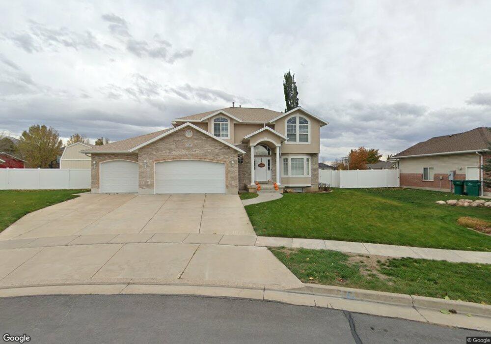
127 W 800 S Layton, UT 84041
Estimated Value: $619,000 - $739,000
5
Beds
4
Baths
3,149
Sq Ft
$214/Sq Ft
Est. Value
About This Home
This home is located at 127 W 800 S, Layton, UT 84041 and is currently estimated at $673,114, approximately $213 per square foot. 127 W 800 S is a home located in Davis County with nearby schools including Layton Elementary School, Fairfield Junior High School, and Davis High School.
Ownership History
Date
Name
Owned For
Owner Type
Purchase Details
Closed on
Oct 26, 2021
Sold by
Robinson Jeffrey and Robinson Brianne
Bought by
Robinson Jeffrey R and Robinson Brianne
Current Estimated Value
Purchase Details
Closed on
Jul 23, 2014
Sold by
Robinson Jeffrey and Robinson Brianne
Bought by
Robinson Jeffrey and Robinson Brianne
Purchase Details
Closed on
Mar 15, 2014
Sold by
Wright John W and Wright Merilyn H
Bought by
Robinson Jeffrey and Robinson Brianne
Home Financials for this Owner
Home Financials are based on the most recent Mortgage that was taken out on this home.
Original Mortgage
$204,000
Interest Rate
4.16%
Mortgage Type
New Conventional
Purchase Details
Closed on
Mar 2, 2012
Sold by
Randall Matthew D and Randall Jennifer
Bought by
Wright Jon W and Wright Merilyn H
Purchase Details
Closed on
Jan 21, 2000
Sold by
Green L Dale
Bought by
Randall Matthew D and Randall Jennifer
Home Financials for this Owner
Home Financials are based on the most recent Mortgage that was taken out on this home.
Original Mortgage
$202,900
Interest Rate
8.75%
Purchase Details
Closed on
Sep 21, 1999
Sold by
Green & Green Lc
Bought by
Green L Dale
Home Financials for this Owner
Home Financials are based on the most recent Mortgage that was taken out on this home.
Original Mortgage
$190,000
Interest Rate
8.09%
Mortgage Type
Construction
Create a Home Valuation Report for This Property
The Home Valuation Report is an in-depth analysis detailing your home's value as well as a comparison with similar homes in the area
Home Values in the Area
Average Home Value in this Area
Purchase History
| Date | Buyer | Sale Price | Title Company |
|---|---|---|---|
| Robinson Jeffrey R | -- | None Available | |
| Robinson Jeffrey | -- | Advanced Title Ins | |
| Robinson Jeffrey | -- | Advanced Title Ins | |
| Wright Jon W | -- | Hickman Land Title C | |
| Randall Matthew D | -- | Security Title Company | |
| Green L Dale | -- | Security Title Company |
Source: Public Records
Mortgage History
| Date | Status | Borrower | Loan Amount |
|---|---|---|---|
| Previous Owner | Robinson Jeffrey | $204,000 | |
| Previous Owner | Randall Matthew D | $202,900 | |
| Previous Owner | Green L Dale | $190,000 |
Source: Public Records
Tax History Compared to Growth
Tax History
| Year | Tax Paid | Tax Assessment Tax Assessment Total Assessment is a certain percentage of the fair market value that is determined by local assessors to be the total taxable value of land and additions on the property. | Land | Improvement |
|---|---|---|---|---|
| 2025 | $3,259 | $342,100 | $123,902 | $218,198 |
| 2024 | $3,074 | $325,050 | $134,239 | $190,811 |
| 2023 | $3,085 | $575,000 | $138,534 | $436,466 |
| 2022 | $3,385 | $342,650 | $82,795 | $259,855 |
| 2021 | $2,789 | $421,000 | $124,191 | $296,809 |
| 2020 | $2,527 | $366,000 | $105,497 | $260,503 |
| 2019 | $2,609 | $370,000 | $105,815 | $264,185 |
| 2018 | $2,416 | $344,000 | $93,075 | $250,925 |
| 2016 | $2,490 | $182,930 | $39,081 | $143,849 |
| 2015 | $2,492 | $173,800 | $39,081 | $134,719 |
| 2014 | $2,497 | $178,051 | $39,081 | $138,970 |
| 2013 | -- | $143,043 | $37,058 | $105,985 |
Source: Public Records
Map
Nearby Homes
- 774 W Farming Way
- 268 E 900 S
- 267 S Melody St
- 282 E 925 S
- 562 S 850 W
- 256 Seemore Dr
- 174 W Dawson St
- 1038 S Old Towne Rd
- 1429 W Lincoln Way
- 1042 W Shoreline Dr
- 71 S Harvs Ln
- 362 S 950 W
- 473 E Alice Way
- 493 E Alice Way
- Creighton Farmhouse Plan at Angel Hill
- 129 N Mountain Vistas Rd
- 296 S 950 W
- 355 W Gentile St
- 356 W 25 N
- 593 Kimball Dr