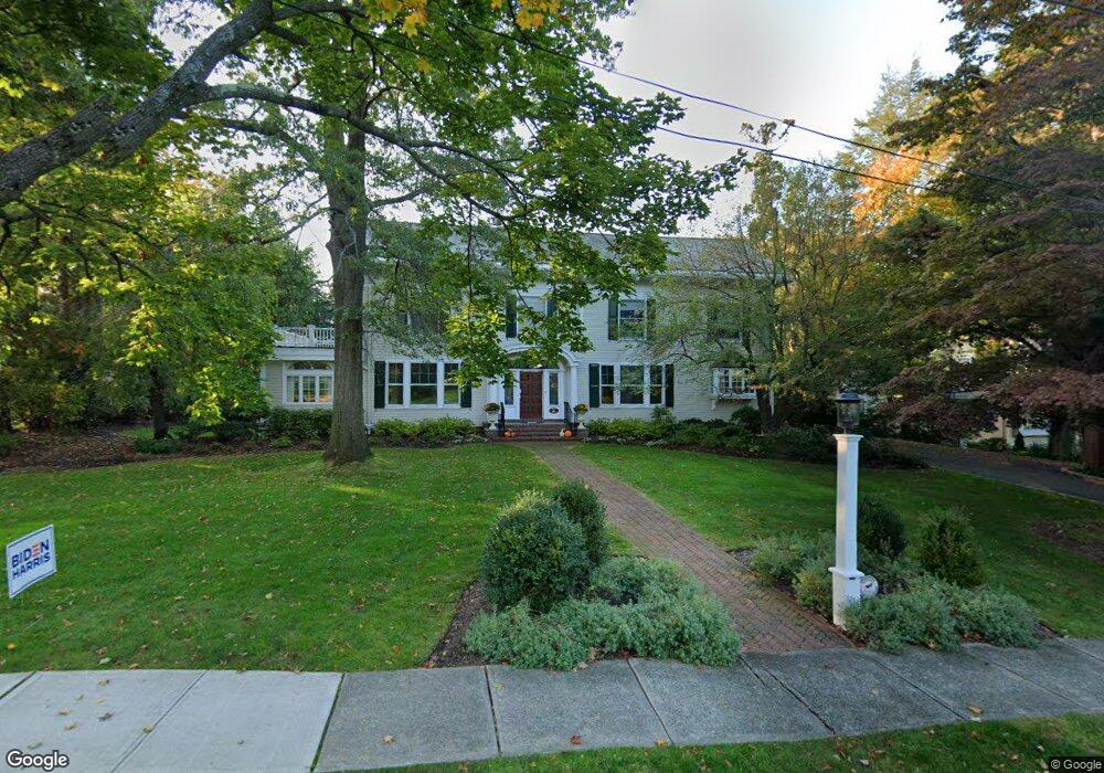
127 Whittredge Rd Summit, NJ 07901
Estimated Value: $3,852,448 - $4,769,000
--
Bed
--
Bath
5,231
Sq Ft
$829/Sq Ft
Est. Value
About This Home
This home is located at 127 Whittredge Rd, Summit, NJ 07901 and is currently estimated at $4,337,149, approximately $829 per square foot. 127 Whittredge Rd is a home located in Union County with nearby schools including L C Johnson Summit Middle School, Summit Sr High School, and Kent Place School.
Ownership History
Date
Name
Owned For
Owner Type
Purchase Details
Closed on
Jul 9, 1999
Sold by
Courtenay Adrian H and Courtenay Dana
Bought by
Dyer Rex and Dyer Suzanne
Current Estimated Value
Purchase Details
Closed on
Feb 17, 1998
Sold by
Boyce David M and Boyce Dana B
Bought by
Courtenay Adrian H
Home Financials for this Owner
Home Financials are based on the most recent Mortgage that was taken out on this home.
Original Mortgage
$975,000
Interest Rate
7.03%
Create a Home Valuation Report for This Property
The Home Valuation Report is an in-depth analysis detailing your home's value as well as a comparison with similar homes in the area
Home Values in the Area
Average Home Value in this Area
Purchase History
| Date | Buyer | Sale Price | Title Company |
|---|---|---|---|
| Dyer Rex | $1,912,500 | -- | |
| Courtenay Adrian H | $1,500,000 | Chicago Title Insurance Co |
Source: Public Records
Mortgage History
| Date | Status | Borrower | Loan Amount |
|---|---|---|---|
| Previous Owner | Courtenay Adrian H | $975,000 |
Source: Public Records
Tax History Compared to Growth
Tax History
| Year | Tax Paid | Tax Assessment Tax Assessment Total Assessment is a certain percentage of the fair market value that is determined by local assessors to be the total taxable value of land and additions on the property. | Land | Improvement |
|---|---|---|---|---|
| 2025 | $54,276 | $1,246,000 | $416,200 | $829,800 |
| 2024 | $53,914 | $1,246,000 | $416,200 | $829,800 |
| 2023 | $53,914 | $1,246,000 | $416,200 | $829,800 |
| 2022 | $53,366 | $1,246,000 | $416,200 | $829,800 |
| 2021 | $53,790 | $1,246,000 | $416,200 | $829,800 |
| 2020 | $54,326 | $1,246,000 | $416,200 | $829,800 |
| 2019 | $54,388 | $1,246,000 | $416,200 | $829,800 |
| 2018 | $54,039 | $1,246,000 | $416,200 | $829,800 |
| 2017 | $54,388 | $1,246,000 | $416,200 | $829,800 |
| 2016 | $53,590 | $1,246,000 | $416,200 | $829,800 |
| 2015 | $52,544 | $1,246,000 | $416,200 | $829,800 |
| 2014 | $57,167 | $1,391,600 | $416,200 | $975,400 |
Source: Public Records
Map
Nearby Homes
- 58 Prospect Hill Ave
- 160 Springfield Ave
- 10 Waldron Ave
- 39 Huntley Rd
- 1 Irving Place
- 103 Park Ave Unit E206
- 103 Park Ave Unit E201
- 133 Summit Ave Unit 10
- 181 Summit Ave
- 28 Morris Ave Unit G4
- 50 Parmley Place Unit 203
- 59 West Rd
- 16 West Rd
- 23 Euclid Ave
- 60 Fernwood Rd
- 41A Middle Ave
- 10 Henry St
- 115 Beechwood Rd
- 16 Beauvoir Ave
- 55 Oxbow Ln
- 123 Whittredge Rd
- 129 Whittredge Rd
- 25 Lenox Rd
- 31 Lenox Rd
- 130 Whittredge Rd
- 124 Whittredge Rd
- 37 Lenox Rd
- 17 Lenox Rd
- 20 Prospect Hill Ave
- 113 Whittredge Rd
- 100 Prospect Hill Ave
- 133 Whittredge Rd
- 11 Lenox Rd
- 45 Lenox Rd
- 111 Whittredge Rd
- 20 Lenox Rd
- 18 Lenox Rd
- 26 Lenox Rd
- 32 Lenox Rd
- 94 Prospect Hill Ave