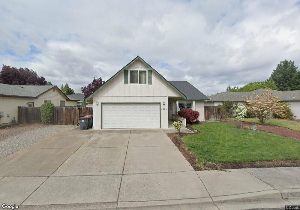
1271 Heather Ln Central Point, OR 97502
Estimated Value: $412,000 - $440,000
3
Beds
2
Baths
1,578
Sq Ft
$271/Sq Ft
Est. Value
About This Home
This home is located at 1271 Heather Ln, Central Point, OR 97502 and is currently estimated at $427,845, approximately $271 per square foot. 1271 Heather Ln is a home located in Jackson County with nearby schools including Howard Elementary School, McLoughlin Middle School, and North Medford High School.
Ownership History
Date
Name
Owned For
Owner Type
Purchase Details
Closed on
Apr 17, 2006
Sold by
Layton Gordon L and Layton Erma J
Bought by
Layton Gordon L and Layton Erma J
Current Estimated Value
Purchase Details
Closed on
May 3, 2001
Sold by
Layton Gordon L and Layton Erma J
Bought by
Layton Gordon L and Layton Erma J
Home Financials for this Owner
Home Financials are based on the most recent Mortgage that was taken out on this home.
Original Mortgage
$98,700
Interest Rate
6.89%
Create a Home Valuation Report for This Property
The Home Valuation Report is an in-depth analysis detailing your home's value as well as a comparison with similar homes in the area
Purchase History
| Date | Buyer | Sale Price | Title Company |
|---|---|---|---|
| Layton Gordon L | -- | None Available | |
| Layton Gordon L | -- | Lawyers Title Insurance Corp |
Source: Public Records
Mortgage History
| Date | Status | Borrower | Loan Amount |
|---|---|---|---|
| Closed | Layton Gordon L | $98,700 | |
| Closed | Layton Gordon L | $129,000 |
Source: Public Records
Tax History
| Year | Tax Paid | Tax Assessment Tax Assessment Total Assessment is a certain percentage of the fair market value that is determined by local assessors to be the total taxable value of land and additions on the property. | Land | Improvement |
|---|---|---|---|---|
| 2026 | $4,281 | $239,160 | -- | -- |
| 2025 | $4,180 | $232,200 | $73,450 | $158,750 |
| 2024 | $4,180 | $225,440 | $71,310 | $154,130 |
| 2023 | $4,060 | $218,880 | $69,240 | $149,640 |
| 2022 | $3,672 | $218,880 | $69,240 | $149,640 |
| 2021 | $3,874 | $212,510 | $67,220 | $145,290 |
| 2020 | $3,803 | $206,330 | $65,260 | $141,070 |
| 2019 | $3,730 | $194,500 | $61,520 | $132,980 |
| 2018 | $3,631 | $188,840 | $59,730 | $129,110 |
| 2017 | $3,444 | $188,840 | $59,730 | $129,110 |
| 2016 | $3,417 | $178,000 | $56,310 | $121,690 |
| 2015 | $3,171 | $178,000 | $56,310 | $121,690 |
| 2014 | $2,997 | $167,790 | $53,080 | $114,710 |
Source: Public Records
Map
Nearby Homes
- 3358 Bursell Rd
- 1204 Heather Ln
- 3364 Bursell Rd
- 959 Westrop Dr
- 1258 Joshua Ct
- 14 Scholarship Way
- 18 Scholarship Way
- 736 Hemlock Ave
- 3600 N Pacific Hwy
- 887 Silver Fox Dr
- 2717 Elliott Ave
- 2727 Connell Ave
- 918 Brandi Way
- 1025 Fairfield Ave
- 2825 Howard Ave
- 105 Queens Gate Ct
- 755 S 4th St
- 2817 Howard Ave
- 533 Brittni Ln
- 171 Mellecker Way
- 1261 Heather Ln
- 1281 Heather Ln
- 11012 Heather Ln
- 1272 Greentree Way
- 1252 Greentree Way
- 1251 Heather Ln
- 1301 Heather Ln
- 1292 Greentree Way
- 862 Westrop Dr
- 1231 Heather Ln
- 1322 Greentree Way
- 861 Westrop Dr
- 1312 Heather Ln
- 866 Westrop Dr
- 1222 Greentree Way
- 865 Westrop Dr
- 1221 Heather Ln
- 1251 Greentree Way
- 1341 Heather Ln
Your Personal Tour Guide
Ask me questions while you tour the home.