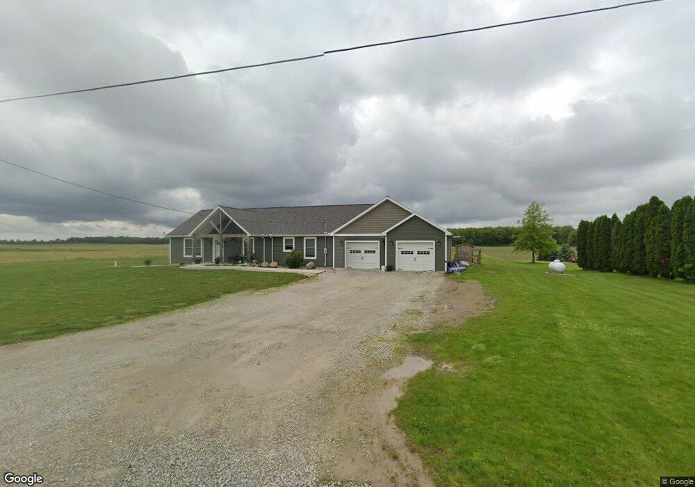
12711 Frysinger Rd Rockford, OH 45882
Estimated Value: $246,000 - $406,000
3
Beds
2
Baths
2,016
Sq Ft
$166/Sq Ft
Est. Value
About This Home
This home is located at 12711 Frysinger Rd, Rockford, OH 45882 and is currently estimated at $334,660, approximately $166 per square foot. 12711 Frysinger Rd is a home located in Mercer County with nearby schools including Parkway Elementary School, Parkway Middle School, and Parkway High School.
Ownership History
Date
Name
Owned For
Owner Type
Purchase Details
Closed on
May 19, 2017
Sold by
High Jason E
Bought by
Shaffer Alexander L and Shaffer Erin D
Current Estimated Value
Home Financials for this Owner
Home Financials are based on the most recent Mortgage that was taken out on this home.
Original Mortgage
$28,000
Outstanding Balance
$5,497
Interest Rate
4.1%
Mortgage Type
Closed End Mortgage
Estimated Equity
$329,163
Purchase Details
Closed on
Jun 18, 2002
Bought by
High Jason E
Create a Home Valuation Report for This Property
The Home Valuation Report is an in-depth analysis detailing your home's value as well as a comparison with similar homes in the area
Home Values in the Area
Average Home Value in this Area
Purchase History
| Date | Buyer | Sale Price | Title Company |
|---|---|---|---|
| Shaffer Alexander L | $35,000 | Attorney | |
| High Jason E | $32,500 | -- |
Source: Public Records
Mortgage History
| Date | Status | Borrower | Loan Amount |
|---|---|---|---|
| Open | Shaffer Alexander L | $28,000 |
Source: Public Records
Tax History Compared to Growth
Tax History
| Year | Tax Paid | Tax Assessment Tax Assessment Total Assessment is a certain percentage of the fair market value that is determined by local assessors to be the total taxable value of land and additions on the property. | Land | Improvement |
|---|---|---|---|---|
| 2024 | $4,081 | $120,960 | $9,170 | $111,790 |
| 2023 | $4,081 | $120,960 | $9,170 | $111,790 |
| 2022 | $3,308 | $79,350 | $8,820 | $70,530 |
| 2021 | $3,254 | $79,350 | $8,820 | $70,530 |
| 2020 | $1,651 | $79,350 | $8,820 | $70,530 |
| 2019 | $336 | $8,230 | $8,230 | $0 |
| 2018 | $647 | $16,280 | $8,230 | $8,050 |
| 2017 | $440 | $16,280 | $8,230 | $8,050 |
| 2016 | $501 | $13,790 | $7,070 | $6,720 |
| 2015 | $496 | $13,790 | $7,070 | $6,720 |
| 2014 | $496 | $13,790 | $7,070 | $6,720 |
| 2013 | $594 | $14,980 | $7,700 | $7,280 |
Source: Public Records
Map
Nearby Homes
- 5062 Mercer van Wert County Line Rd
- 7957 W Bridge St
- 208 Market St
- 208 W Pearl St
- 0 Rockford West Rd Unit Lots 14- 28
- 15845 Uus 127
- 108 S Ball Rd
- 0 Wilson Unit 1037059
- 0 Wilson Unit 306333
- 12029 Dutton Rd
- 0 Drake St
- 206 Glenn St
- 9289 Wren Landeck Rd
- 8323 Deep Cut Rd
- 11164 Erastus Durbin Rd
- 9155 Us Route 127
- 12242 Dustman Rd
- 0 Stirn Rd Unit 308464
- 11309 Dull Robinson Rd
- 8478 Zook Rd
- 12725 Frysinger Rd
- 12646 Frysinger Rd
- 12793 Frysinger Rd
- 12831 Frysinger Rd
- 12565 Frysinger Rd
- 12943 Frysinger Rd
- 4880 Mercer van Wert County Line Rd
- 12428 Frysinger Rd
- 10759 van Wert Mercer County Line Rd
- 5341 State Route 117
- 5341 Ohio 117
- 11083 van Wert Mercer County Line Rd
- 12622 Godfrey Reserve Rd
- 11255 van Wert Mercer County Line Rd
- 12651 Godfrey Reserve Rd
- 12681 Godfrey Reserve Rd
- 5277 State Route 117
- 18779 Burris Rd
- 12312 Frysinger Rd
- 4554 Mercer van Wert County Line Rd