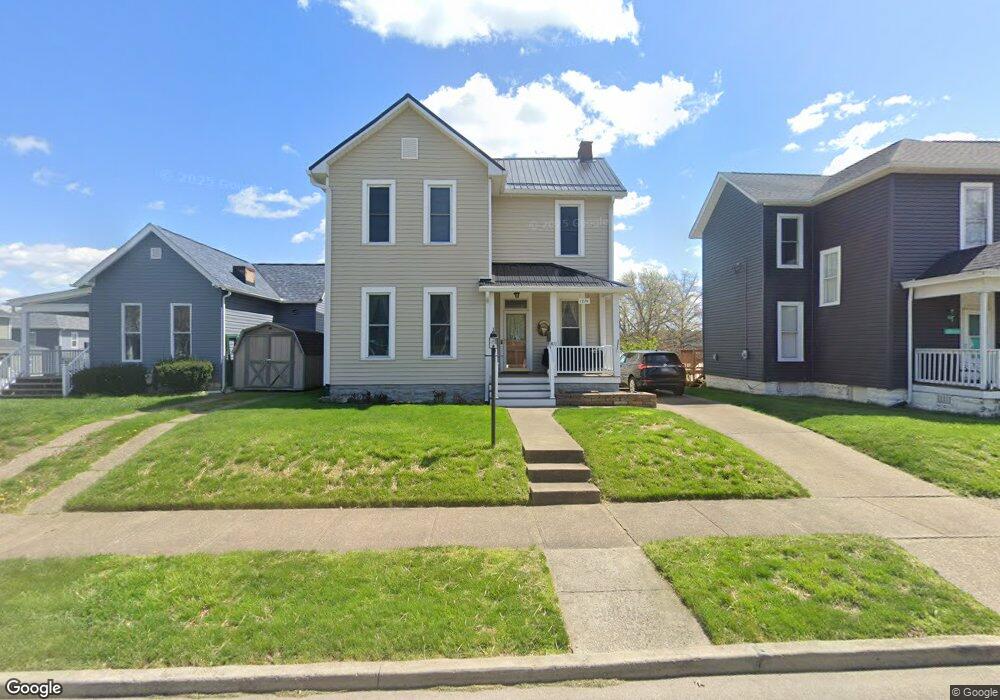
1274 Euclid Ave Zanesville, OH 43701
Estimated Value: $183,000 - $232,000
3
Beds
1
Bath
1,644
Sq Ft
$122/Sq Ft
Est. Value
About This Home
This home is located at 1274 Euclid Ave, Zanesville, OH 43701 and is currently estimated at $201,307, approximately $122 per square foot. 1274 Euclid Ave is a home located in Muskingum County with nearby schools including John McIntire Elementary School, Zanesville Middle School, and Zanesville High School.
Ownership History
Date
Name
Owned For
Owner Type
Purchase Details
Closed on
Aug 6, 2025
Sold by
Norris Jerry L and Norris Wanda J
Bought by
Norris Jerry L and Norris Wanda J
Current Estimated Value
Purchase Details
Closed on
Jun 18, 2010
Sold by
Norris Jerry L
Bought by
Miller Cheryl L
Home Financials for this Owner
Home Financials are based on the most recent Mortgage that was taken out on this home.
Original Mortgage
$133,000
Interest Rate
4.97%
Mortgage Type
Seller Take Back
Create a Home Valuation Report for This Property
The Home Valuation Report is an in-depth analysis detailing your home's value as well as a comparison with similar homes in the area
Home Values in the Area
Average Home Value in this Area
Purchase History
| Date | Buyer | Sale Price | Title Company |
|---|---|---|---|
| Norris Jerry L | -- | None Listed On Document | |
| Miller Cheryl L | $138,000 | None Available |
Source: Public Records
Mortgage History
| Date | Status | Borrower | Loan Amount |
|---|---|---|---|
| Previous Owner | Miller Cheryl L | $133,000 |
Source: Public Records
Tax History Compared to Growth
Tax History
| Year | Tax Paid | Tax Assessment Tax Assessment Total Assessment is a certain percentage of the fair market value that is determined by local assessors to be the total taxable value of land and additions on the property. | Land | Improvement |
|---|---|---|---|---|
| 2024 | $1,205 | $42,980 | $5,775 | $37,205 |
| 2023 | $1,079 | $36,995 | $3,185 | $33,810 |
| 2022 | $1,077 | $36,995 | $3,185 | $33,810 |
| 2021 | $1,067 | $36,995 | $3,185 | $33,810 |
| 2020 | $857 | $30,835 | $2,660 | $28,175 |
| 2019 | $857 | $30,835 | $2,660 | $28,175 |
| 2018 | $870 | $30,835 | $2,660 | $28,175 |
| 2017 | $735 | $26,670 | $2,660 | $24,010 |
| 2016 | $746 | $26,670 | $2,660 | $24,010 |
| 2015 | $748 | $26,670 | $2,660 | $24,010 |
| 2013 | $832 | $26,670 | $2,660 | $24,010 |
Source: Public Records
Map
Nearby Homes
- 1430 Euclid Ave
- 370 Sheridan St
- 1435 Bluff St
- 1264 Linden Ave
- 513 Van Horn Ave
- 1119 Abbey Place
- 1417 Central Ave
- 720 Locust Ave
- 641 Fairmont Ave
- 357 Mcconnell Ave
- 626 Saint Louis Ave
- 1516 Myrtle Ave
- 714 Saint Louis Ave
- 1643 Linden Ave
- 933 Adair Ave
- 919 Sunset Ave
- 1968 Dresden Rd
- 1630 Marion Ave
- 955 Adair Ave
- 839 Brown St
- 1268 Euclid Ave
- 494 Forest Ave
- 1258 Euclid Ave
- 490 Forest Ave
- 502 Forest Ave
- 409 Thurman St
- 1267 Euclid Ave
- 1267 Euclid Ave Unit 2
- 407 Thurman St
- 484 Forest Ave
- 484 Forest Ave Unit 484
- 484 Forest Ave Unit 484.5
- 401 Thurman St
- 510 Forest Ave
- 480 Forest Ave
- 497 Forest Ave
- 507 Thurman St
- 493 Forest Ave
- 516 Forest Ave
- 505-507 Forest Ave