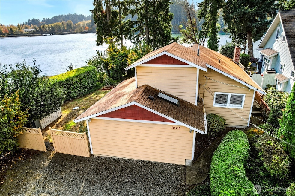
1275 NE South Peterson Rd Keyport, WA 98345
Estimated payment $3,742/month
Highlights
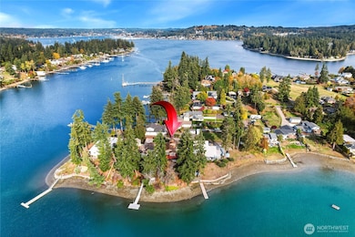
- Low Bank Waterfront Property
- Views of a Sound
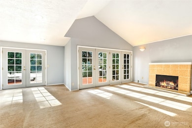
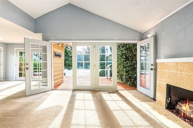
- 2 Fireplaces
- North Kitsap High School Rated A-
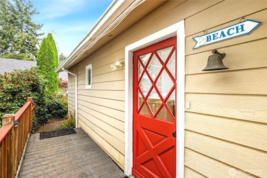
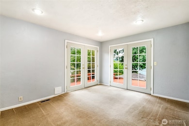
- Deck
- No HOA
About This Home
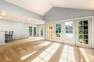
Experience affordable waterfront living in the charming village of Keyport! This tastefully updated home offers a spacious open-concept living and dining area filled with natural light from multiple French doors showcasing amazing water views. With three bedrooms—each on its own level for privacy—the primary suite features a walk-in closet, cozy fireplace, and ensuite with dual vanities, jetted tub, and separate shower. Enjoy a large deck overlooking the Puget Sound, garden space, storage shed, and private stairs to the beach. Conveniently located near shopping, amenities, ferries, and the naval base. Mortgage savings may be available for buyers of this listing.
Listing Agent
Sheryl Wingate
Redfin License #111727 Listed on: 10/31/2025

Source: Northwest Multiple Listing Service (NWMLS)
MLS#: 2451156
Home Details
Home Type
- Single Family
Est. Annual Taxes
- $5,343
Year Built
- Built in 1941
Lot Details
- 0.29 Acre Lot
- Low Bank Waterfront Property
- Home fronts a sound
- Garden
Property Views
- Views of a Sound
- Bay
- Territorial
Home Design
- Block Foundation
- Poured Concrete
- Composition Roof
- Wood Siding
Interior Spaces
- 1,402 Sq Ft Home
- Multi-Level Property
- 2 Fireplaces
- Gas Fireplace
Kitchen
- Stove
- Microwave
- Dishwasher
Flooring
- Carpet
- Laminate
Bedrooms and Bathrooms
- Bathroom on Main Level
Laundry
- Dryer
- Washer
Parking
- Driveway
- Off-Street Parking
Outdoor Features
- Deck
- Patio
Utilities
- Forced Air Heating System
- Septic Tank
- High Speed Internet
Community Details
- No Home Owners Association
- Keyport Subdivision
Listing and Financial Details
- Down Payment Assistance Available
- Visit Down Payment Resource Website
- Assessor Parcel Number 35260110362000
Map
Home Values in the Area
Average Home Value in this Area
Tax History
| Year | Tax Paid | Tax Assessment Tax Assessment Total Assessment is a certain percentage of the fair market value that is determined by local assessors to be the total taxable value of land and additions on the property. | Land | Improvement |
|---|---|---|---|---|
| 2026 | $5,343 | $591,160 | $270,840 | $320,320 |
| 2025 | $5,343 | $591,160 | $270,840 | $320,320 |
| 2024 | $5,570 | $637,450 | $280,900 | $356,550 |
| 2023 | $4,825 | $541,010 | $254,770 | $286,240 |
| 2022 | $4,261 | $452,090 | $212,310 | $239,780 |
| 2021 | $4,092 | $401,230 | $187,810 | $213,420 |
| 2020 | $3,641 | $350,360 | $163,310 | $187,050 |
| 2019 | $3,647 | $350,360 | $163,310 | $187,050 |
| 2018 | $3,200 | $275,090 | $125,380 | $149,710 |
| 2017 | $3,216 | $275,090 | $125,380 | $149,710 |
| 2016 | $3,482 | $275,090 | $125,380 | $149,710 |
| 2015 | $3,263 | $259,230 | $125,380 | $133,850 |
| 2014 | -- | $237,420 | $125,380 | $112,040 |
| 2013 | -- | $237,420 | $125,380 | $112,040 |
Property History
| Date | Event | Price | List to Sale | Price per Sq Ft |
|---|---|---|---|---|
| 11/26/2025 11/26/25 | For Sale | $626,950 | 0.0% | $447 / Sq Ft |
| 11/04/2025 11/04/25 | Pending | -- | -- | -- |
| 10/31/2025 10/31/25 | For Sale | $626,950 | -- | $447 / Sq Ft |
Purchase History
| Date | Type | Sale Price | Title Company |
|---|---|---|---|
| Bargain Sale Deed | $150,000 | First American Title Ins | |
| Trustee Deed | $157,192 | First American Title Ins |
Mortgage History
| Date | Status | Loan Amount | Loan Type |
|---|---|---|---|
| Open | $120,000 | Unknown | |
| Closed | $14,950 | No Value Available |
Source: Northwest Multiple Listing Service (NWMLS)
MLS Number: 2451156
APN: 352601-1-036-2000
Disclaimer: Certain information contained herein is derived from information provided by parties other than Homes.com. All information provided is deemed reliable, but is not guaranteed to be accurate and should be independently verified.
![]() All data is obtained from various sources and may not have been verified by broker or MLS GRID. Supplied Open House Information is subject to change without notice. All information should be independently reviewed and verified for accuracy. Properties may or may not be listed by the office/agent presenting the information. Listing information is provided by the Northwest Multiple Listing Service (NWMLS). Property information is based on available data that may include MLS information, county records, and other sources. Listings marked with the 3 tree icon and provided by NWMLS. All properties are subject to prior sale or withdrawal. IDX information is provided exclusively for consumers’ personal noncommercial use, that it may not be used for any purpose other than to identify prospective properties consumers may be interested in purchasing, that the data is deemed reliable but is not guaranteed by MLS GRID. ©2025 NWMLS.
All data is obtained from various sources and may not have been verified by broker or MLS GRID. Supplied Open House Information is subject to change without notice. All information should be independently reviewed and verified for accuracy. Properties may or may not be listed by the office/agent presenting the information. Listing information is provided by the Northwest Multiple Listing Service (NWMLS). Property information is based on available data that may include MLS information, county records, and other sources. Listings marked with the 3 tree icon and provided by NWMLS. All properties are subject to prior sale or withdrawal. IDX information is provided exclusively for consumers’ personal noncommercial use, that it may not be used for any purpose other than to identify prospective properties consumers may be interested in purchasing, that the data is deemed reliable but is not guaranteed by MLS GRID. ©2025 NWMLS.
Based on information submitted to the MLS GRID
- 15485 NE Peterson Rd
- 1922 NE Fir St
- 1533 NE Tagholm Rd
- 1954 NE Grandview Blvd
- 15739 Virginia Loop Rd NE
- 1354 Hoffs Dr
- 13423 Graywolf Place NE
- 16460 Scandia Rd NW
- 17008 Peterson Way NE
- 0 Lemolo Shore Parcel 4-019 Dr NE
- 0 NE Solar View Ct
- 0 Lemolo Shore Parcel 3-006 Dr NE
- 2300 NE Solar View Ct
- 0 XX Lemolo Shore Dr NE
- 17535 NE Midnight Sun Loop
- 17529 NE Midnight Sun Loop
- 17542 NE Midnight Sun Loop
- 17548 NE Midnight Sun Loop
- 17530 NE Midnight Sun Loop
- 17523 NE Midnight Sun Loop
- 17360 Viking Way NW
- 2122 NE Hostmark St
- 19089 Jensen Way NE
- 1001 Deer Harbor Ln NW
- 12240 Daphne Ln NW
- 1204-1206 NW Tahoe Ln
- 19660 10th Ave NE
- 19630 Ash Crest Loop NE
- 12188 Cloudy Peak Ln NW
- 2033 NW Bobwhite Ln
- 1501 Ambercrest Way NW
- 19764 3rd Ave NE Unit D50
- 1415 NW Santa fe Ln
- 11153-11153 Shipside Ln NW
- 20043 Winton Ln NW
- 20283 1st Ave NE
- 20455 1st Ave NE
- 21056 Viking Ave NW
- 11501 Clear Creek Rd NW
- 11421 Clear Creek Rd NW