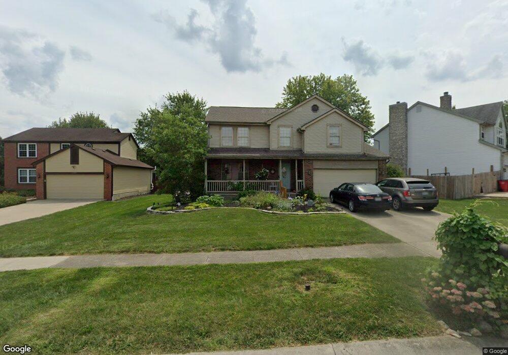
1277 Misty Pine Ct Grove City, OH 43123
Estimated Value: $396,000 - $436,000
4
Beds
3
Baths
2,238
Sq Ft
$186/Sq Ft
Est. Value
About This Home
This home is located at 1277 Misty Pine Ct, Grove City, OH 43123 and is currently estimated at $416,535, approximately $186 per square foot. 1277 Misty Pine Ct is a home located in Franklin County with nearby schools including Buckeye Woods Elementary School, Hayes Intermediate School, and Jackson Middle School.
Ownership History
Date
Name
Owned For
Owner Type
Purchase Details
Closed on
Oct 18, 2018
Sold by
Denman Robert L
Bought by
Denman Amy B
Current Estimated Value
Purchase Details
Closed on
Apr 6, 2005
Sold by
Worrell William E and Worrell Patricia D
Bought by
Denman Robert L and Denman Amy B
Home Financials for this Owner
Home Financials are based on the most recent Mortgage that was taken out on this home.
Original Mortgage
$173,600
Outstanding Balance
$88,886
Interest Rate
5.66%
Mortgage Type
Purchase Money Mortgage
Estimated Equity
$327,649
Purchase Details
Closed on
Nov 25, 1994
Sold by
Trinity Home Builders In
Bought by
Worrell William E and Worrell Patricia D
Home Financials for this Owner
Home Financials are based on the most recent Mortgage that was taken out on this home.
Original Mortgage
$142,550
Interest Rate
9%
Mortgage Type
VA
Purchase Details
Closed on
Jun 17, 1993
Create a Home Valuation Report for This Property
The Home Valuation Report is an in-depth analysis detailing your home's value as well as a comparison with similar homes in the area
Home Values in the Area
Average Home Value in this Area
Purchase History
| Date | Buyer | Sale Price | Title Company |
|---|---|---|---|
| Denman Amy B | -- | None Available | |
| Denman Robert L | $217,000 | Chicago Tit | |
| Worrell William E | $138,435 | -- | |
| -- | $58,800 | -- |
Source: Public Records
Mortgage History
| Date | Status | Borrower | Loan Amount |
|---|---|---|---|
| Open | Denman Robert L | $173,600 | |
| Closed | Worrell William E | $142,550 |
Source: Public Records
Tax History Compared to Growth
Tax History
| Year | Tax Paid | Tax Assessment Tax Assessment Total Assessment is a certain percentage of the fair market value that is determined by local assessors to be the total taxable value of land and additions on the property. | Land | Improvement |
|---|---|---|---|---|
| 2024 | $5,483 | $120,580 | $34,020 | $86,560 |
| 2023 | $5,406 | $120,575 | $34,020 | $86,555 |
| 2022 | $5,106 | $83,730 | $14,740 | $68,990 |
| 2021 | $5,871 | $83,730 | $14,740 | $68,990 |
| 2020 | $5,341 | $83,730 | $14,740 | $68,990 |
| 2019 | $4,753 | $70,010 | $12,290 | $57,720 |
| 2018 | $4,748 | $70,010 | $12,290 | $57,720 |
| 2017 | $4,700 | $70,010 | $12,290 | $57,720 |
| 2016 | $4,760 | $65,670 | $13,480 | $52,190 |
| 2015 | $4,772 | $65,670 | $13,480 | $52,190 |
| 2014 | $4,765 | $65,670 | $13,480 | $52,190 |
| 2013 | $2,142 | $62,545 | $12,845 | $49,700 |
Source: Public Records
Map
Nearby Homes
- 1370 Wild Horse Dr
- 6003 Windcliff Dr E
- 6295 Rising Sun Dr
- 1019 Morning Bird Ct
- 6259 Rising Sun Dr
- 6090 Windcliff Dr E
- 1016 Bumblebee End
- 6032 Sweet Basil Ln
- 6132 Windcliff Dr E
- 6477 Buckeye Path Dr S
- 6075 Sweet Basil Ln
- 6279 Honey Farm Way
- 6343 Honey Farm Way
- 5924 Morning Bird Ct
- 1042 Queen Bee Place
- 6247 Honey Farm Way
- 6229 Brookmeade Cir
- 1571 Cree Ct
- 1028 Beehive Grove
- 5990 Sweet Basil Ln
- 1267 Misty Pine Ct
- 1287 Misty Pine Ct
- 1276 River Trail Dr
- 1266 River Trail Dr
- 1286 River Trail Dr
- 1257 Misty Pine Ct
- 1256 River Trail Dr
- 1274 Misty Pine Ct
- 1284 Misty Pine Ct
- 1264 Misty Pine Ct
- 1294 Red Bank Dr
- 1283 Red Bank Dr
- 1254 Misty Pine Ct
- 1247 Misty Pine Ct
- 1273 Red Bank Dr
- 1246 River Trail Dr
- 1296 Red Bank Dr
- 1293 Red Bank Dr
- 1271 River Trail Dr
- 1244 Misty Pine Ct