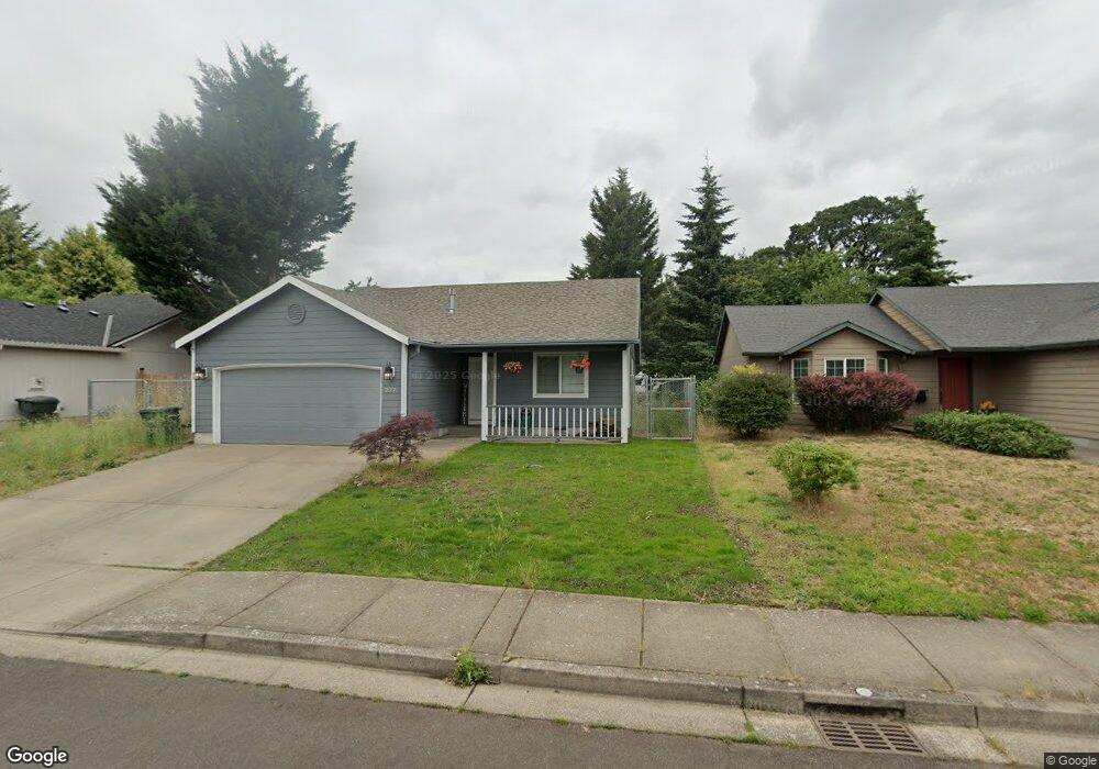
1277 Ring St NE Keizer, OR 97303
Estimated Value: $390,000 - $445,000
3
Beds
2
Baths
1,246
Sq Ft
$330/Sq Ft
Est. Value
About This Home
This home is located at 1277 Ring St NE, Keizer, OR 97303 and is currently estimated at $411,347, approximately $330 per square foot. 1277 Ring St NE is a home located in Marion County with nearby schools including Weddle Elementary School, Claggett Creek Middle School, and McNary High School.
Ownership History
Date
Name
Owned For
Owner Type
Purchase Details
Closed on
May 30, 2023
Sold by
Carter Roy Eugene
Bought by
Arellano Salvador Perez
Current Estimated Value
Purchase Details
Closed on
Jul 18, 2018
Sold by
Oakes Roger S and Oakes Tobbi A
Bought by
Carter Roy
Home Financials for this Owner
Home Financials are based on the most recent Mortgage that was taken out on this home.
Original Mortgage
$242,500
Interest Rate
4.5%
Mortgage Type
New Conventional
Purchase Details
Closed on
Aug 28, 2001
Sold by
Pacific Construction Inc
Bought by
Oakes Roger S and Oakes Tobbi A
Home Financials for this Owner
Home Financials are based on the most recent Mortgage that was taken out on this home.
Original Mortgage
$127,635
Interest Rate
7.25%
Mortgage Type
Purchase Money Mortgage
Create a Home Valuation Report for This Property
The Home Valuation Report is an in-depth analysis detailing your home's value as well as a comparison with similar homes in the area
Home Values in the Area
Average Home Value in this Area
Purchase History
| Date | Buyer | Sale Price | Title Company |
|---|---|---|---|
| Arellano Salvador Perez | $309,800 | Amerititle | |
| Carter Roy | $250,000 | Ticor Title Co Of Oregon | |
| Oakes Roger S | $126,100 | Fidelity National Title Co |
Source: Public Records
Mortgage History
| Date | Status | Borrower | Loan Amount |
|---|---|---|---|
| Previous Owner | Carter Roy | $242,500 | |
| Previous Owner | Oakes Roger S | $127,635 |
Source: Public Records
Tax History
| Year | Tax Paid | Tax Assessment Tax Assessment Total Assessment is a certain percentage of the fair market value that is determined by local assessors to be the total taxable value of land and additions on the property. | Land | Improvement |
|---|---|---|---|---|
| 2025 | $3,157 | $189,330 | -- | -- |
| 2024 | $3,157 | $183,820 | -- | -- |
| 2023 | $3,005 | $178,470 | $0 | $0 |
| 2022 | $2,830 | $173,280 | $0 | $0 |
| 2021 | $2,739 | $168,240 | $0 | $0 |
| 2020 | $2,668 | $163,340 | $0 | $0 |
| 2019 | $2,567 | $158,590 | $0 | $0 |
| 2018 | $2,615 | $0 | $0 | $0 |
| 2017 | $2,351 | $0 | $0 | $0 |
| 2016 | $2,254 | $0 | $0 | $0 |
| 2015 | $2,259 | $0 | $0 | $0 |
| 2014 | $2,186 | $0 | $0 | $0 |
Source: Public Records
Map
Nearby Homes
- 3774 Homestead Ct NE
- 1377 Krysti Ct NE
- 1095 Candlewood Dr NE
- 3515 Brooks Ave NE
- 3860 Brooks Ave NE
- 3705 Cherry Ave NE
- 4030 Hennessy Ln NE
- 4025 Filbert Ave NE
- 500 Bever Dr NE
- 4020 Gary St NE
- 3984 Pleasant View Dr NE
- 1202 Leo St NE
- 4035 Arnold St NE
- 3515 Brooks Ave NE
- 1241 Leo St NE
- 4100 Arnold St NE
- 132 Sunset Ave N Unit 168
- 3650 Mainline Dr NE
- 4370 Gary St NE
- 1660 Sieburg St NE
- 1277 Ring Ln NE
- 1267 Ring Ln NE
- 1267 Ring St NE
- 1287 Ring Ln NE
- 1257 Ring Ln NE
- 1276 Ring St NE
- 1297 Ring Ln NE
- 1276 Ring Ln NE
- 1266 Ring Ln NE
- 1286 Ring Ln NE
- 1207 Ring St NE
- 1256 Ring Ln NE
- 3753 Homestead Ct NE
- 3763 Homestead Ct NE
- 1247 Ring Ln NE
- 3723 Shady Ct NE
- 1246 Ring Ln NE
- 1175 Shady Ln NE
- 1232 Clearview Ave NE
- 1237 Ring Ln NE
Your Personal Tour Guide
Ask me questions while you tour the home.