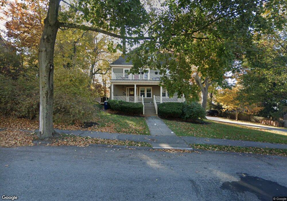
1277 Walnut St Newton Highlands, MA 02461
Newton Highlands NeighborhoodEstimated Value: $1,697,000 - $2,026,000
4
Beds
3
Baths
3,162
Sq Ft
$583/Sq Ft
Est. Value
About This Home
This home is located at 1277 Walnut St, Newton Highlands, MA 02461 and is currently estimated at $1,842,527, approximately $582 per square foot. 1277 Walnut St is a home located in Middlesex County with nearby schools including Countryside Elementary School, Charles E Brown Middle School, and Newton South High School.
Ownership History
Date
Name
Owned For
Owner Type
Purchase Details
Closed on
Jan 8, 2009
Sold by
Larkin Joseph A and Larkin Margaret M
Bought by
Ardiff Emma C and Flaherty Joseph P
Current Estimated Value
Home Financials for this Owner
Home Financials are based on the most recent Mortgage that was taken out on this home.
Original Mortgage
$300,000
Outstanding Balance
$197,673
Interest Rate
5.99%
Mortgage Type
Purchase Money Mortgage
Estimated Equity
$1,644,854
Purchase Details
Closed on
Aug 13, 1992
Sold by
Zausmer Elizabeth
Bought by
Larkin Joseph A and Larkin Margaret M
Home Financials for this Owner
Home Financials are based on the most recent Mortgage that was taken out on this home.
Original Mortgage
$184,400
Interest Rate
8.26%
Mortgage Type
Purchase Money Mortgage
Create a Home Valuation Report for This Property
The Home Valuation Report is an in-depth analysis detailing your home's value as well as a comparison with similar homes in the area
Home Values in the Area
Average Home Value in this Area
Purchase History
| Date | Buyer | Sale Price | Title Company |
|---|---|---|---|
| Ardiff Emma C | $1,000,000 | -- | |
| Larkin Joseph A | $230,500 | -- |
Source: Public Records
Mortgage History
| Date | Status | Borrower | Loan Amount |
|---|---|---|---|
| Open | Ardiff Emma C | $300,000 | |
| Previous Owner | Larkin Joseph A | $25,000 | |
| Previous Owner | Larkin Joseph A | $184,000 | |
| Previous Owner | Larkin Joseph A | $184,400 |
Source: Public Records
Tax History Compared to Growth
Tax History
| Year | Tax Paid | Tax Assessment Tax Assessment Total Assessment is a certain percentage of the fair market value that is determined by local assessors to be the total taxable value of land and additions on the property. | Land | Improvement |
|---|---|---|---|---|
| 2025 | $13,964 | $1,424,900 | $966,100 | $458,800 |
| 2024 | $13,502 | $1,383,400 | $938,000 | $445,400 |
| 2023 | $11,709 | $1,150,200 | $724,600 | $425,600 |
| 2022 | $11,204 | $1,065,000 | $670,900 | $394,100 |
| 2021 | $10,811 | $1,004,700 | $632,900 | $371,800 |
| 2020 | $11,616 | $1,112,600 | $632,900 | $479,700 |
| 2019 | $11,288 | $1,080,200 | $614,500 | $465,700 |
| 2018 | $10,861 | $1,003,800 | $549,900 | $453,900 |
| 2017 | $10,531 | $947,000 | $518,800 | $428,200 |
| 2016 | $10,071 | $885,000 | $484,900 | $400,100 |
| 2015 | $9,603 | $827,100 | $453,200 | $373,900 |
Source: Public Records
Map
Nearby Homes
- 1292 Walnut St
- 1308 Walnut St
- 125 Oakdale Rd
- 1629 Centre St
- 1623-1625 Centre St
- 1597 Centre St Unit 1597
- 1597 Centre St
- 1151 Walnut St Unit 205
- 1151 Walnut St Unit 405
- 1151 Walnut St Unit 207
- 116 Upland Ave
- 671 Boylston St
- 250 Woodcliff Rd
- 3 Glenmore Terrace Unit 2
- 19 Selwyn Rd
- 628 Boylston St
- 42 Sunhill Ln
- 625 Boylston St
- 36 Cannon St
- 21 Philbrick Rd
- 1281 Walnut St Unit 2
- 1281 Walnut St Unit 1
- 1281 Walnut St
- 79 Shady Hill Rd
- 85 Shady Hill Rd
- 7 Ashcroft Rd
- 50 Walnut Place
- 11 Ashcroft Rd
- 1289 Walnut St
- 44 Walnut Place
- 44 Walnut Place Unit 2
- 44 Walnut Place
- 44 Walnut Place Unit Entire Home
- 50 Walnut Place
- 91 Shady Hill Rd
- 1273 Walnut St
- 1273 Walnut St Unit 1273
- 15 Ashcroft Rd
- 82 Shady Hill Rd
- 60 Walnut Place