12770 N US Highway 27 Ocala, FL 34482
Fellowship NeighborhoodEstimated payment $11,464/month
Highlights
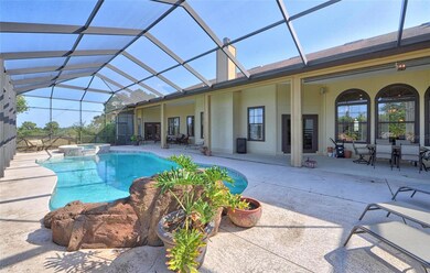
- Screened Pool
- 10.26 Acre Lot
- Wood Flooring
- West Port High School Rated A-
- Outdoor Fireplace
- Bonus Room
About This Home
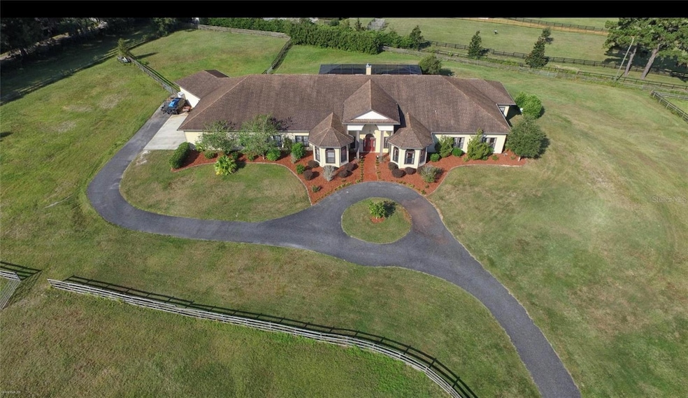
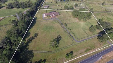
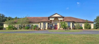
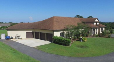
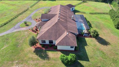
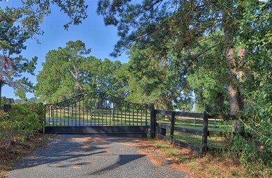
Welcome to Hilltop Estate where you can live the Premiere Equestrian Lifestyle complete with 10.23 incredible acres located in the equine community of Pinnacle Park featuring a stunning 8160 Sq. Ft. home with 6 bedrooms and 4 1/2 baths and a large spacious 4 car garage! The home and grounds have been meticulously maintained offering privacy and serenity just minutes from HITS and WEC! There are so many custom features in this home including soaring 12 foot ceilings, stunning wood beams, crown molding, granite, 5,000 sq. ft. of imported tiles, 3-5 ton AC units and all wrapped in hardboard siding. Elegantly updated a grand foyer leads to the open floor plan featuring a spacious Livingroom w/ gas fireplace and plenty of natural lighting, gourmet kitchen, stainless steel appliance and large pantry make it perfect for entertaining or daily use, private office with bay window allows you to enjoy the view, master bedroom and spacious sitting area with your own private wet bar! Updated Ensuite bath for a real spa retreat at the end of a day. Enjoy your screed solar heated pool and spa along with a rock waterfall feature. New roof, water heater landscape lighting, whole house surge protection and a whole house generator, security system, and Star Link Wi-Fi! Designed for the modern family combining luxury living with functional design. This farm has beautiful rolling hills, wood fencing, and 5 paddocks with access to the riding trails throughout the community. If you are seeking a slice of Ocala paradise this one checks all the boxes. Contact us for a showing today!
Listing Agent
PEGASUS REALTY & ASSOC INC Brokerage Phone: 352-629-4505 License #0371345 Listed on: 11/25/2025
Property Details
Property Type
- Other
Est. Annual Taxes
- $20,325
Year Built
- Built in 2005
Lot Details
- 10.26 Acre Lot
- Southwest Facing Home
- Property is zoned A1
Parking
- 4 Car Attached Garage
Home Design
- Farm
- Slab Foundation
- Frame Construction
- Shingle Roof
- HardiePlank Type
Interior Spaces
- 12,578 Sq Ft Home
- 1-Story Property
- Crown Molding
- Fireplace
- Living Room
- Dining Room
- Bonus Room
- Laundry Room
Kitchen
- Eat-In Kitchen
- Range
- Microwave
- Dishwasher
- Trash Compactor
Flooring
- Wood
- Tile
Bedrooms and Bathrooms
- 6 Bedrooms
Pool
- Screened Pool
- In Ground Pool
- Gunite Pool
- Fence Around Pool
- In Ground Spa
Outdoor Features
- Outdoor Fireplace
- Private Mailbox
Schools
- Fessenden Elementary School
- Howard Middle School
- West Port High School
Utilities
- Central Air
- Heat Pump System
- Well
- Septic Tank
- Cable TV Available
Community Details
- No Home Owners Association
- Pinnacle Park 02 Subdivision
Listing and Financial Details
- Tax Lot 2
- Assessor Parcel Number 12442-002-00
Map
Home Values in the Area
Average Home Value in this Area
Tax History
| Year | Tax Paid | Tax Assessment Tax Assessment Total Assessment is a certain percentage of the fair market value that is determined by local assessors to be the total taxable value of land and additions on the property. | Land | Improvement |
|---|---|---|---|---|
| 2024 | $20,325 | $1,244,360 | -- | -- |
| 2023 | $19,579 | $1,131,499 | $0 | $0 |
| 2022 | $16,602 | $1,028,316 | $0 | $0 |
| 2021 | $17,538 | $1,049,829 | $197,280 | $852,549 |
| 2020 | $10,758 | $671,730 | $0 | $0 |
| 2019 | $10,624 | $656,798 | $0 | $0 |
| 2018 | $10,044 | $644,647 | $0 | $0 |
| 2017 | $9,867 | $631,543 | $0 | $631,543 |
| 2016 | $9,785 | $618,708 | $0 | $0 |
| 2015 | $9,882 | $614,459 | $0 | $0 |
| 2014 | $9,300 | $609,642 | $0 | $0 |
Property History
| Date | Event | Price | List to Sale | Price per Sq Ft |
|---|---|---|---|---|
| 11/25/2025 11/25/25 | For Sale | $1,850,000 | -- | $147 / Sq Ft |
Purchase History
| Date | Type | Sale Price | Title Company |
|---|---|---|---|
| Warranty Deed | $724,000 | Affiliated Ttl Of Ctrl Fl Lt |
Mortgage History
| Date | Status | Loan Amount | Loan Type |
|---|---|---|---|
| Open | $579,200 | New Conventional |
Source: Stellar MLS
MLS Number: OM713776
APN: 12442-002-00
Disclaimer: Certain information contained herein is derived from information provided by parties other than Homes.com. All information provided is deemed reliable, but is not guaranteed to be accurate and should be independently verified.
![]() IDX information is provided exclusively for personal, non-commercial use, and may not be used for any purpose other than to identify prospective properties consumers may be interested in purchasing. Information is deemed reliable but not guaranteed.
IDX information is provided exclusively for personal, non-commercial use, and may not be used for any purpose other than to identify prospective properties consumers may be interested in purchasing. Information is deemed reliable but not guaranteed.
Listing Information presented by local MLS brokerage: Ten-X - (888)-952-6393
- 8010 NW 125th Ave
- 12444 N US Highway 27
- 9160 NW 131 Ct
- 5293 NW 48th Place
- 5268 NW 48th Place
- 5279 NW 48th Place
- 5231 NW 48th Place
- 12255 N Us Highway 27
- 7505 NW 137th Ave
- 12061 W Highway 326
- 8901 NW 137th Ave
- 8020 NW 115th Ave
- 4677 NW 51st Ct
- 7670 NW 137th Ave
- TBD(10.87ac) NW 115th Ave
- TBD(21.76ac) NW 115th Ave
- 8548 NW 115th Ave
- 12080 NW 100th St
- 13192 NW 97th Place
- 13586 U S 27
- 9290 NW 125th Ave
- 9422 NW 125th Ave
- 4677 NW 51st Ct
- 9450 NW 150th Ave
- 15355 W Highway 326
- 1388 NW 44th Court Rd
- 5391 NW 153rd Ct
- 5363 NW 153rd Ct
- 4750 SE 216th Ave
- 10380 NW 21st St
- 3876 NW 85th Terrace
- 5598 NW 78th Ct
- 8101 NW 46th St
- 928 NW 111th Ct
- 16265 NW 130th St
- 12250 NW 7th Place
- 4511 NW 79th Terrace Rd
- 11183 NW 7th St
- 14515 W Highway 328
- 4841 NW 76th Ct
