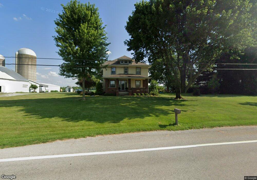
12777 State Route 29 Saint Marys, OH 45885
Estimated Value: $403,568 - $615,000
4
Beds
3
Baths
4,148
Sq Ft
$120/Sq Ft
Est. Value
About This Home
This home is located at 12777 State Route 29, Saint Marys, OH 45885 and is currently estimated at $498,892, approximately $120 per square foot. 12777 State Route 29 is a home located in Auglaize County with nearby schools including St. Mary's East Primary School, St. Mary's West Intermediate School, and St. Marys Middle School.
Ownership History
Date
Name
Owned For
Owner Type
Purchase Details
Closed on
Oct 19, 2023
Sold by
Walter Sarah K and Walter Gregory J
Bought by
Walter Sarah K and Walter Gregory J
Current Estimated Value
Purchase Details
Closed on
Feb 26, 2003
Sold by
Jones Gregory G
Bought by
Walter Sarah K
Purchase Details
Closed on
Jun 14, 1996
Sold by
Mckee Rees A and Mckee Debra K
Bought by
Jones Gregory G
Purchase Details
Closed on
Sep 30, 1994
Sold by
Jones Gregory G
Bought by
Mckee Rees A and Mckee Debra K
Purchase Details
Closed on
Aug 1, 1989
Create a Home Valuation Report for This Property
The Home Valuation Report is an in-depth analysis detailing your home's value as well as a comparison with similar homes in the area
Home Values in the Area
Average Home Value in this Area
Purchase History
| Date | Buyer | Sale Price | Title Company |
|---|---|---|---|
| Walter Sarah K | -- | None Listed On Document | |
| Walter Sarah K | -- | None Listed On Document | |
| Walter Sarah K | $61,000 | -- | |
| Jones Gregory G | -- | -- | |
| Mckee Rees A | -- | -- | |
| -- | $190,000 | -- |
Source: Public Records
Tax History Compared to Growth
Tax History
| Year | Tax Paid | Tax Assessment Tax Assessment Total Assessment is a certain percentage of the fair market value that is determined by local assessors to be the total taxable value of land and additions on the property. | Land | Improvement |
|---|---|---|---|---|
| 2024 | $8,511 | $111,340 | $8,910 | $102,430 |
| 2023 | $4,163 | $111,340 | $8,910 | $102,430 |
| 2022 | $3,235 | $77,010 | $7,430 | $69,580 |
| 2021 | $3,215 | $77,010 | $7,430 | $69,580 |
| 2020 | $3,221 | $77,011 | $7,431 | $69,580 |
| 2019 | $2,792 | $64,271 | $6,192 | $58,079 |
| 2018 | $2,792 | $64,271 | $6,192 | $58,079 |
| 2017 | $2,796 | $64,271 | $6,192 | $58,079 |
| 2016 | $2,244 | $51,696 | $5,898 | $45,798 |
| 2015 | $2,195 | $51,696 | $5,898 | $45,798 |
| 2014 | $2,211 | $51,696 | $5,898 | $45,798 |
| 2013 | $2,299 | $51,696 | $5,898 | $45,798 |
Source: Public Records
Map
Nearby Homes
- 116 Meadowbrook Ln
- 200 N Knoxville Ave Unit 7
- 1015 Columbia St
- 0 S Beech St
- 408 S Vine St
- 216 Beech St
- 403 S Vine St
- 105 Maple St
- 602 Weston St
- 811 Columbia St
- 125 Beech St
- 911 Cleveland Ave
- 712 Columbia St
- 405 E Spring St
- 520 Oil St
- 437 Woodward St
- 134 N Front St
- 428 W Spring St
- 332 Miami Erie Cir
- 324 Miami Erie Cir
- 12787 State Route 29
- 12797 State Route 29
- 12805 Ohio 29
- 12805 State Route 29
- 12703 State Route 29
- 12825 Ohio 29
- 12825 State Route 29
- 12698 State Route 29
- 12853 State Route 29
- 12690 State Route 29
- 12871 State Route
- 12871 Ohio 29
- 12871 State Route 29
- 12938 State Route 29
- 12938 Ohio 29
- 12968 State Route 29
- 13115 Barrington Rd
- 13145 Barrington Rd
- 05751 Washington Pike
- 5751 Washington Pike Rd