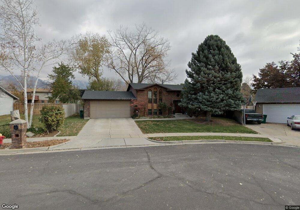
1278 N 1000 E Layton, UT 84040
Estimated Value: $438,000 - $492,000
4
Beds
2
Baths
1,032
Sq Ft
$446/Sq Ft
Est. Value
About This Home
This home is located at 1278 N 1000 E, Layton, UT 84040 and is currently estimated at $460,190, approximately $445 per square foot. 1278 N 1000 E is a home located in Davis County with nearby schools including King Elementary School, Central Davis Junior High School, and Layton High School.
Ownership History
Date
Name
Owned For
Owner Type
Purchase Details
Closed on
May 16, 2017
Sold by
Applegate Scott Jay and Applegate Lynda Lee
Bought by
Applegate Scott and Applegate Lynda
Current Estimated Value
Home Financials for this Owner
Home Financials are based on the most recent Mortgage that was taken out on this home.
Original Mortgage
$90,000
Interest Rate
4.08%
Mortgage Type
New Conventional
Create a Home Valuation Report for This Property
The Home Valuation Report is an in-depth analysis detailing your home's value as well as a comparison with similar homes in the area
Home Values in the Area
Average Home Value in this Area
Purchase History
| Date | Buyer | Sale Price | Title Company |
|---|---|---|---|
| Applegate Scott | -- | Artisan Title |
Source: Public Records
Mortgage History
| Date | Status | Borrower | Loan Amount |
|---|---|---|---|
| Closed | Applegate Scott | $90,000 |
Source: Public Records
Tax History
| Year | Tax Paid | Tax Assessment Tax Assessment Total Assessment is a certain percentage of the fair market value that is determined by local assessors to be the total taxable value of land and additions on the property. | Land | Improvement |
|---|---|---|---|---|
| 2025 | $2,243 | $235,400 | $118,147 | $117,253 |
| 2024 | $2,148 | $227,150 | $143,037 | $84,113 |
| 2023 | $2,125 | $396,000 | $195,288 | $200,712 |
| 2022 | $2,228 | $225,500 | $104,537 | $120,963 |
| 2021 | $2,054 | $310,000 | $158,754 | $151,246 |
| 2020 | $1,795 | $260,000 | $127,193 | $132,807 |
| 2019 | $1,770 | $251,000 | $113,913 | $137,087 |
| 2018 | $1,622 | $231,000 | $87,635 | $143,365 |
| 2016 | $172 | $103,180 | $46,342 | $56,838 |
| 2015 | $1,371 | $95,590 | $46,342 | $49,248 |
| 2014 | $231 | $87,569 | $46,342 | $41,227 |
| 2013 | -- | $92,580 | $22,748 | $69,832 |
Source: Public Records
Map
Nearby Homes
- 1048 E Cherry Ln
- 1258 E North Lisa St
- 1033 E 825 N
- 997 E 825 N
- 1340 E Hollyhock Way
- 1266 E Larkspur Way
- 1354 E Hollyhock Way
- 1350 Kays Creek Dr
- 1305 E Larkspur Way
- 1156 Cherrywood Dr
- 1545 E 975 N
- 1476 Kays Creek Dr
- 1920 N Camellia Way Unit 406
- 1930 N Camellia Way E Unit 407
- 861 E 575 N
- 556 N Fairfield Rd Unit A2
- 556 N Fairfield Rd Unit D1
- 556 N Fairfield Rd Unit D2
- 556 N Fairfield Rd Unit A3
- 556 N Fairfield Rd Unit D3
- 1034 Springtree Dr
- 1297 Kimberly Dr
- 1294 N 1000 E
- 1297 N 1100 E
- 1267 N 1100 E
- 1267 Kimberly Dr
- 1315 Kimberly Dr
- 1020 E 1275 N
- 1020 Springtree Dr
- 1253 N 1100 E
- 1291 N 1000 E
- 1253 Kimberly Dr
- 1316 N 1000 E
- 1325 Kimberly Dr
- 1311 N 1000 E
- 1006 Springtree Dr
- 1242 N Fairfield Rd
- 1272 N 1100 E
- 1241 Kimberly Dr
- 1272 Kimberly Dr
Your Personal Tour Guide
Ask me questions while you tour the home.