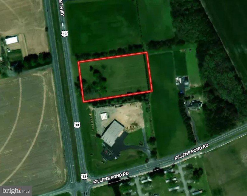
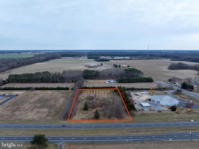
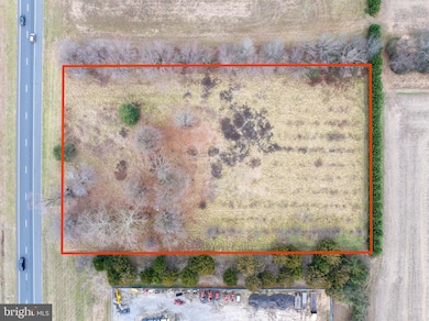
12793 S Dupont Hwy Felton, DE 19943
Estimated payment $1,938/month
About This Lot
2.7+/- acres of cleared Commercial land. Located on Rt13 Northbound in Felton. Property is zoned BG - General Business. Permitted uses listed in document attached.
Listing Agent
(410) 991-8498 collin@thelandgroup.us The Land Group License #5015007 Listed on: 12/09/2024
Property Details
Property Type
- Land
Est. Annual Taxes
- $548
Lot Details
- 2.7 Acre Lot
- Lot Dimensions are 1.00 x 0.00
- Property is zoned BG, included in documents
Utilities
- Well Required
- No Septic System
Community Details
- No Home Owners Association
Listing and Financial Details
- Tax Lot 4900-000
- Assessor Parcel Number SM-00-13900-01-4900-000
Map
Home Values in the Area
Average Home Value in this Area
Tax History
| Year | Tax Paid | Tax Assessment Tax Assessment Total Assessment is a certain percentage of the fair market value that is determined by local assessors to be the total taxable value of land and additions on the property. | Land | Improvement |
|---|---|---|---|---|
| 2025 | $774 | $152,900 | $152,900 | $0 |
| 2024 | $774 | $152,900 | $152,900 | $0 |
| 2023 | $226 | $9,600 | $9,600 | $0 |
| 2022 | $202 | $9,600 | $9,600 | $0 |
| 2021 | $191 | $9,600 | $9,600 | $0 |
| 2020 | $199 | $9,600 | $9,600 | $0 |
| 2019 | $199 | $9,600 | $9,600 | $0 |
| 2018 | $197 | $9,600 | $9,600 | $0 |
| 2017 | $205 | $9,600 | $0 | $0 |
| 2016 | $188 | $9,600 | $0 | $0 |
| 2015 | -- | $9,600 | $0 | $0 |
| 2014 | -- | $9,600 | $0 | $0 |
Property History
| Date | Event | Price | List to Sale | Price per Sq Ft |
|---|---|---|---|---|
| 03/17/2025 03/17/25 | Price Changed | $360,000 | -4.0% | -- |
| 12/09/2024 12/09/24 | For Sale | $375,000 | -- | -- |
Purchase History
| Date | Type | Sale Price | Title Company |
|---|---|---|---|
| Deed | $340,000 | None Available | |
| Deed | $399,900 | None Available | |
| Deed | $55,000 | -- |
Mortgage History
| Date | Status | Loan Amount | Loan Type |
|---|---|---|---|
| Previous Owner | $382,834 | FHA |
Source: Bright MLS
MLS Number: DEKT2033670
APN: 8-00-13900-01-4900-000
Disclaimer: Certain information contained herein is derived from information provided by parties other than Homes.com. All information provided is deemed reliable, but is not guaranteed to be accurate and should be independently verified.
![]() The data relating to real estate for sale on this website appears in part through the BRIGHT Internet Data Exchange program, a voluntary cooperative exchange of property listing data between licensed real estate brokerage firms, and is provided by BRIGHT through a licensing agreement.
The data relating to real estate for sale on this website appears in part through the BRIGHT Internet Data Exchange program, a voluntary cooperative exchange of property listing data between licensed real estate brokerage firms, and is provided by BRIGHT through a licensing agreement.
Listing information is from various brokers who participate in the Bright MLS IDX program and not all listings may be visible on the site.
The property information being provided on or through the website is for the personal, non-commercial use of consumers and such information may not be used for any purpose other than to identify prospective properties consumers may be interested in purchasing.
Some properties which appear for sale on the website may no longer be available because they are for instance, under contract, sold or are no longer being offered for sale.
Property information displayed is deemed reliable but is not guaranteed.
Copyright 2025 Bright MLS, Inc.
- Lot #1 S Dupont Hwy
- 25 E High St
- 216 W High St
- 9507 Burnite Mill Rd
- 115 W High St
- 1495 Midstate Rd
- 18 Cattle Dr
- Lot 18 Burnite Mill Rd
- Lot 17 Burnite Mill Rd
- Lot 16 Burnite Mill Rd
- 208 S Ridge Brook Dr
- Cordoba Plan at Satterfield
- Asheville Plan at Satterfield
- Aberdeen Plan at Satterfield
- Fayetteville Plan at Satterfield
- Barcelona Plan at Satterfield
- 169 N Ridge Brook Dr
- 13 Burning Oak Dr
- 4 Hopkins Cemetery Rd
- 519 Marshyhope Rd
- 1497 Chimney Hill Rd
- 107 W High St
- 164 River Cliff Cir
- 185 Plantation Dr
- 100 Friendship Village Dr
- 307 Farmhouse Trail
- 74 Redstone Ct
- 438 Lorraine Dr
- 609 Olde Field Dr
- 7193 Whiteleysburg Rd
- 103 Jackson St
- 47 Currant Cir
- 3370 Gun and Rod Club Rd
- 99 Galena Rd
- 3072 Gun and Rod Club Rd
- 991 Church Hill Rd
- 111 Williamsville Rd
- 111 Sunset Cir
- 1022 Fawn Haven Walk
- 43 Carroll Ln
