


12795 S 4200 Rd Claremore, OK 74017
Estimated payment $705/month
Highlights
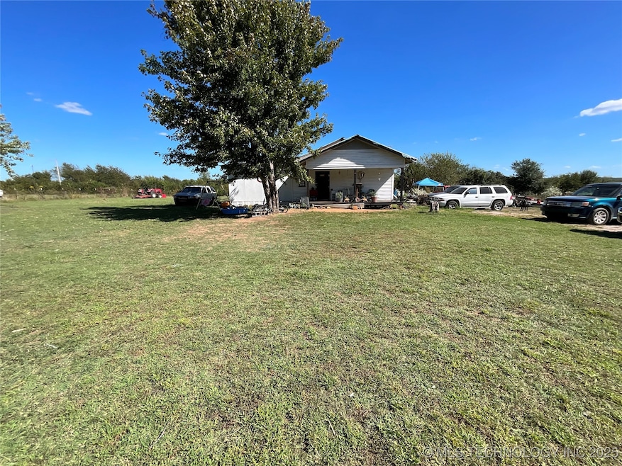
- Mature Trees
- Ceiling Fan
- West Facing Home
- No HOA
- Cross Fenced
- 1-Story Property
About This Home
Investment Opportunity!
Spacious 6-bedroom, 1-bath home situated on 1.25 acre of land. This property offers great potential for investors or those looking to create their dream home. The home is partially completed and ready for finishing touches — giving you the opportunity to customize it to your liking. Plenty of space inside and out, with room to add value and make it your own. As is
Home Details
Home Type
- Single Family
Est. Annual Taxes
- $557
Year Built
- Built in 1950
Lot Details
- 1.25 Acre Lot
- West Facing Home
- Cross Fenced
- Mature Trees
Home Design
- Wood Frame Construction
- Metal Roof
- Vinyl Siding
Interior Spaces
- 1,770 Sq Ft Home
- 1-Story Property
- Ceiling Fan
- Vinyl Clad Windows
- Laminate Flooring
- Crawl Space
Kitchen
- Oven
- Stove
- Range
- Laminate Countertops
Bedrooms and Bathrooms
- 6 Bedrooms
- 1 Full Bathroom
Schools
- Foyil Elementary School
- Foyil High School
Utilities
- No Cooling
- Gas Water Heater
- Septic Tank
Community Details
- No Home Owners Association
- Rogers Co Unplatted Subdivision
Map
Home Values in the Area
Average Home Value in this Area
Tax History
| Year | Tax Paid | Tax Assessment Tax Assessment Total Assessment is a certain percentage of the fair market value that is determined by local assessors to be the total taxable value of land and additions on the property. | Land | Improvement |
|---|---|---|---|---|
| 2025 | $557 | $6,402 | $2,560 | $3,842 |
| 2024 | $557 | $6,216 | $2,486 | $3,730 |
| 2023 | $557 | $6,035 | $2,381 | $3,654 |
| 2022 | $523 | $5,859 | $2,211 | $3,648 |
| 2021 | $493 | $5,859 | $2,223 | $3,636 |
| 2020 | $495 | $5,689 | $2,073 | $3,616 |
| 2019 | $480 | $5,362 | $1,636 | $3,726 |
| 2018 | $529 | $5,916 | $1,636 | $4,280 |
| 2017 | $526 | $5,874 | $1,636 | $4,238 |
| 2016 | $377 | $4,333 | $1,622 | $2,711 |
| 2015 | $339 | $4,206 | $1,549 | $2,657 |
| 2014 | $343 | $4,084 | $1,403 | $2,681 |
Property History
| Date | Event | Price | List to Sale | Price per Sq Ft |
|---|---|---|---|---|
| 11/12/2025 11/12/25 | For Sale | $125,000 | -- | $71 / Sq Ft |
Purchase History
| Date | Type | Sale Price | Title Company |
|---|---|---|---|
| Interfamily Deed Transfer | -- | None Available | |
| Warranty Deed | $37,500 | None Available | |
| Warranty Deed | $13,500 | -- |
Mortgage History
| Date | Status | Loan Amount | Loan Type |
|---|---|---|---|
| Open | $30,000 | Purchase Money Mortgage |
Source: MLS Technology
MLS Number: 2546905
APN: 660084275
Disclaimer: Certain information contained herein is derived from information provided by parties other than Homes.com. All information provided is deemed reliable, but is not guaranteed to be accurate and should be independently verified.
![]() IDX information is provided exclusively for personal, non-commercial use, and may not be used for any purpose other than to identify prospective properties consumers may be interested in purchasing.
IDX information is provided exclusively for personal, non-commercial use, and may not be used for any purpose other than to identify prospective properties consumers may be interested in purchasing.
Information is deemed reliable but not guaranteed.
- 12667 S Oak Ave
- 11822 S Rawhide Rd
- 12871 S Rd
- 21592 S 4190 Rd
- 21620 S 4190 Rd
- 14397 S 4210 Rd
- 11686 S 4185 Rd
- 10670 S 4200 Rd
- 19071 E Highway 28a
- 10981 S Highway 66
- 17980 E 430 Rd
- 19450 E Acorn Rd
- 0 S 4220 Rd Unit 2530424
- 10781 S Highway 66
- 14480 E 400 Rd
- 14800 S 4220 Rd
- 0 4187 Rd Unit 2507470
- 16762 E 380 Rd
- 19840 E Highway 28 Hwy
- 12160 S 4230 Rd
- 19805 S Lake Dr
- 13856 E Anderson Dr
- 13704 E Anderson Dr
- 800 Highland Ct
- 2107 Cornerstone Ave Unit A
- 1400 W Blue Starr Dr
- 3304 Harbour Town
- 3306 Harbour Town
- 1903 S Lubbock Dr
- 1113 S Spinnaker
- 2404 Pheasant Dr
- 2500 Frederick Rd
- 13565 U S 169
- 10134 E King Place
- 33966 S 4310 Rd
- 2025 N 432
- 315 N Cheatham
- 809 SE 14th St
- 22767 N South 416 Rd
- 3660 W 530 Rd
