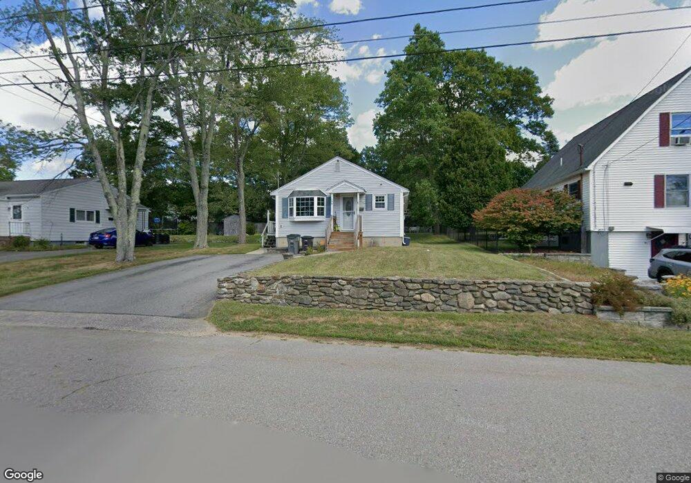
128 Barthel Ave Gardner, MA 01440
Estimated Value: $318,424 - $366,000
3
Beds
1
Bath
1,182
Sq Ft
$291/Sq Ft
Est. Value
About This Home
This home is located at 128 Barthel Ave, Gardner, MA 01440 and is currently estimated at $344,356, approximately $291 per square foot. 128 Barthel Ave is a home located in Worcester County with nearby schools including Gardner High School and Holy Family Academy.
Ownership History
Date
Name
Owned For
Owner Type
Purchase Details
Closed on
Oct 24, 2025
Sold by
17 Bear Hill Road Rt and Callahan
Bought by
Ares Kurt M
Current Estimated Value
Home Financials for this Owner
Home Financials are based on the most recent Mortgage that was taken out on this home.
Original Mortgage
$122,291
Outstanding Balance
$122,063
Interest Rate
6.35%
Mortgage Type
Purchase Money Mortgage
Estimated Equity
$222,293
Purchase Details
Closed on
Dec 14, 2021
Sold by
Callahan David W
Bought by
17 Bear Hill Road Rt and Callahan
Purchase Details
Closed on
Aug 5, 2011
Sold by
Ikonen Richard J and Brideau Angela L
Bought by
Callahan David W
Home Financials for this Owner
Home Financials are based on the most recent Mortgage that was taken out on this home.
Original Mortgage
$102,000
Interest Rate
4.51%
Mortgage Type
Purchase Money Mortgage
Purchase Details
Closed on
Oct 31, 2003
Sold by
Brodeur Lorraine C and Brodeur Richard Rene
Bought by
Brideau Angela L and Ikonen Richard J
Home Financials for this Owner
Home Financials are based on the most recent Mortgage that was taken out on this home.
Original Mortgage
$164,000
Interest Rate
6.05%
Mortgage Type
Purchase Money Mortgage
Create a Home Valuation Report for This Property
The Home Valuation Report is an in-depth analysis detailing your home's value as well as a comparison with similar homes in the area
Home Values in the Area
Average Home Value in this Area
Purchase History
| Date | Buyer | Sale Price | Title Company |
|---|---|---|---|
| Ares Kurt M | $133,200 | -- | |
| 17 Bear Hill Road Rt | -- | None Available | |
| Callahan David W | $127,500 | -- | |
| Callahan David W | $127,500 | -- | |
| Brideau Angela L | $164,000 | -- | |
| Brideau Angela L | $164,000 | -- |
Source: Public Records
Mortgage History
| Date | Status | Borrower | Loan Amount |
|---|---|---|---|
| Open | Ares Kurt M | $122,291 | |
| Previous Owner | Callahan David W | $102,000 | |
| Previous Owner | Brideau Angela L | $164,000 |
Source: Public Records
Tax History
| Year | Tax Paid | Tax Assessment Tax Assessment Total Assessment is a certain percentage of the fair market value that is determined by local assessors to be the total taxable value of land and additions on the property. | Land | Improvement |
|---|---|---|---|---|
| 2025 | $39 | $273,800 | $70,900 | $202,900 |
| 2024 | $3,864 | $257,800 | $64,500 | $193,300 |
| 2023 | $3,673 | $227,700 | $63,600 | $164,100 |
| 2022 | $3,398 | $182,800 | $48,200 | $134,600 |
| 2021 | $3,301 | $164,700 | $41,900 | $122,800 |
| 2020 | $3,156 | $159,900 | $41,900 | $118,000 |
| 2019 | $2,983 | $148,100 | $41,900 | $106,200 |
| 2018 | $2,834 | $139,800 | $41,900 | $97,900 |
| 2017 | $2,718 | $132,700 | $41,900 | $90,800 |
| 2016 | $2,594 | $126,700 | $41,900 | $84,800 |
| 2015 | $2,462 | $123,200 | $41,900 | $81,300 |
| 2014 | $2,366 | $125,400 | $46,500 | $78,900 |
Source: Public Records
Map
Nearby Homes
Your Personal Tour Guide
Ask me questions while you tour the home.