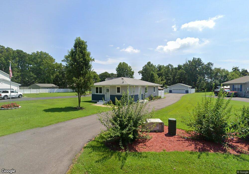
128 Benton Rd Stevensville, MD 21666
Estimated Value: $370,171 - $414,000
--
Bed
1
Bath
1,040
Sq Ft
$371/Sq Ft
Est. Value
About This Home
This home is located at 128 Benton Rd, Stevensville, MD 21666 and is currently estimated at $385,793, approximately $370 per square foot. 128 Benton Rd is a home located in Queen Anne's County with nearby schools including Kent Island Elementary School, Bayside Elementary School, and Stevensville Middle School.
Ownership History
Date
Name
Owned For
Owner Type
Purchase Details
Closed on
Apr 12, 1995
Sold by
Clark Robert N and Clark Robert N Deborah A
Bought by
Clark Robert N
Current Estimated Value
Purchase Details
Closed on
Mar 17, 1983
Sold by
White Robert R
Bought by
Clark Robert N and Clark Deborah A
Home Financials for this Owner
Home Financials are based on the most recent Mortgage that was taken out on this home.
Original Mortgage
$40,500
Interest Rate
12.79%
Create a Home Valuation Report for This Property
The Home Valuation Report is an in-depth analysis detailing your home's value as well as a comparison with similar homes in the area
Home Values in the Area
Average Home Value in this Area
Purchase History
| Date | Buyer | Sale Price | Title Company |
|---|---|---|---|
| Clark Robert N | -- | -- | |
| Clark Robert N | $8,000 | -- |
Source: Public Records
Mortgage History
| Date | Status | Borrower | Loan Amount |
|---|---|---|---|
| Previous Owner | Clark Robert N | $40,500 |
Source: Public Records
Tax History Compared to Growth
Tax History
| Year | Tax Paid | Tax Assessment Tax Assessment Total Assessment is a certain percentage of the fair market value that is determined by local assessors to be the total taxable value of land and additions on the property. | Land | Improvement |
|---|---|---|---|---|
| 2025 | $2,821 | $310,300 | $0 | $0 |
| 2024 | $2,681 | $290,300 | $0 | $0 |
| 2023 | $2,546 | $270,300 | $165,700 | $104,600 |
| 2022 | $2,546 | $270,300 | $165,700 | $104,600 |
| 2021 | $1,322 | $270,300 | $165,700 | $104,600 |
| 2020 | $2,602 | $271,300 | $180,700 | $90,600 |
| 2019 | $2,430 | $253,400 | $0 | $0 |
| 2018 | $2,259 | $235,500 | $0 | $0 |
| 2017 | $2,087 | $217,600 | $0 | $0 |
| 2016 | -- | $214,700 | $0 | $0 |
| 2015 | $2,704 | $211,800 | $0 | $0 |
| 2014 | $2,704 | $208,900 | $0 | $0 |
Source: Public Records
Map
Nearby Homes
- 134 Benton Rd
- 480 Web Foot Ln
- 620 Old Love Point Rd
- 402 Web Foot Ln
- 335 Larch Place
- 717 Cloverfields Dr
- 714 Dixon Dr
- 725 Old Love Point Rd
- 515 Love Point Rd
- 102 Bobbitt Ct
- 132 Kestrel Ln
- 117 Redstart Dr
- 509 Warbler Way
- 164 Redstart Dr
- 130 Sunrise Ct
- 519 Warbler Way
- 527 Warbler Way
- Franklin Plan at K. Hovnanian’s® Four Seasons at Kent Island - 60' Island Series
- Jenkins II Plan at K. Hovnanian’s® Four Seasons at Kent Island - River Series
- Simone Plan at K. Hovnanian’s® Four Seasons at Kent Island - River Series
- 124 Benton Rd
- 130 Benton Rd
- 122 Benton Rd
- 120 Benton Rd
- 116 Cat Tail Ct
- 614 Kimberly Way
- 612 Kimberly Way
- 616 Kimberly Way
- 118 Benton Rd
- 110 Cat Tail Ct
- 618 Kimberly Way
- 115 Cat Tail Ct
- 142 Benton Rd
- 610 Kimberly Way
- 620 Kimberly Way
- 104 Cat Tail Ct
- 105 Cat Tail Ct
- 622 Kimberly Way
- 608 Kimberly Way
- 116 Web Foot Ln