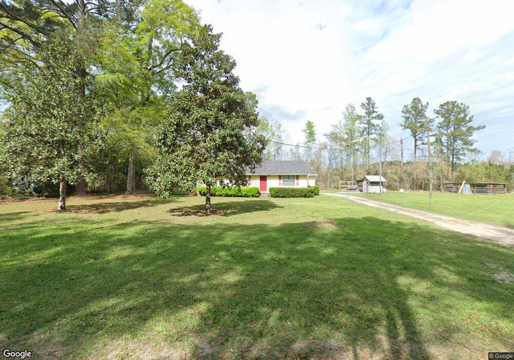
128 Brewton Collins Rd Claxton, GA 30417
Estimated Value: $140,232 - $183,000
3
Beds
2
Baths
1,232
Sq Ft
$127/Sq Ft
Est. Value
About This Home
This home is located at 128 Brewton Collins Rd, Claxton, GA 30417 and is currently estimated at $156,808, approximately $127 per square foot. 128 Brewton Collins Rd is a home located in Evans County with nearby schools including Claxton Elementary School, Second Chance, and Claxton Middle School.
Ownership History
Date
Name
Owned For
Owner Type
Purchase Details
Closed on
Jul 20, 2007
Sold by
Purvis Mark Anthony
Bought by
Noggle Robert
Current Estimated Value
Home Financials for this Owner
Home Financials are based on the most recent Mortgage that was taken out on this home.
Original Mortgage
$80,385
Interest Rate
6.52%
Purchase Details
Closed on
May 4, 1998
Sold by
Purvis Mark A
Bought by
Purvis Mark A
Purchase Details
Closed on
Aug 24, 1994
Sold by
Collins Carroll R and Collins Wanda R
Bought by
Purvis Mark A and Purvis Patricia L
Create a Home Valuation Report for This Property
The Home Valuation Report is an in-depth analysis detailing your home's value as well as a comparison with similar homes in the area
Home Values in the Area
Average Home Value in this Area
Purchase History
| Date | Buyer | Sale Price | Title Company |
|---|---|---|---|
| Noggle Robert | $87,500 | -- | |
| Purvis Mark A | -- | -- | |
| Purvis Mark A | $42,000 | -- |
Source: Public Records
Mortgage History
| Date | Status | Borrower | Loan Amount |
|---|---|---|---|
| Closed | Noggle Robert | $80,385 |
Source: Public Records
Tax History Compared to Growth
Tax History
| Year | Tax Paid | Tax Assessment Tax Assessment Total Assessment is a certain percentage of the fair market value that is determined by local assessors to be the total taxable value of land and additions on the property. | Land | Improvement |
|---|---|---|---|---|
| 2024 | $1,137 | $37,152 | $3,640 | $33,512 |
| 2023 | $840 | $27,152 | $4,720 | $22,432 |
| 2022 | $697 | $27,152 | $4,720 | $22,432 |
| 2021 | $1,014 | $27,428 | $4,720 | $22,708 |
| 2020 | $1,013 | $27,428 | $4,720 | $22,708 |
| 2019 | $823 | $27,428 | $4,720 | $22,708 |
| 2018 | $982 | $27,108 | $4,720 | $22,388 |
| 2017 | $944 | $27,108 | $4,720 | $22,388 |
| 2016 | $910 | $25,052 | $3,000 | $22,052 |
| 2015 | -- | $25,992 | $3,320 | $22,672 |
| 2014 | -- | $25,992 | $3,320 | $22,672 |
| 2013 | -- | $30,252 | $3,320 | $26,932 |
Source: Public Records
Map
Nearby Homes
- 15683 Ga Highway 129 N
- LOT 7 Tupelo Dr
- 628 Riverside Dr
- 1377 Hillside Dr
- 1302 Jim Sapp Rd
- 0 Dr
- 1200 Riverside Dr
- 352 Riverside Dr
- 0 Dublin Rd
- 308 Old Metter Rd
- 0 Turnpike Rd Unit SA339603
- 101 Ridge Dr
- 19 Collins St
- 712 Rosedale Ave
- 610 W Liberty St
- 6 N Spring St
- 3 S Spring St
- 511 W Smith St
- 29 Grove Ln
- 320 N Duval St
- 186 Brewton Collins Rd
- 14359 Ga Highway 129 N
- 325 Brewton Collins Rd
- 1617 Firetower Rd
- 1615 Firetower Rd
- 1965 Firetower Rd
- 1660 Firetower Rd
- 14528 Ga Highway 129 N
- 14999 Ga Highway 129 N
- 521 Firetower Cir
- 14630 Highway 129
- 1536 Firetower Rd
- 14328 Ga Highway 129 N
- 14478 Ga Highway 129 N
- 658 Firetower Cir
- 605 Firetower Cir
- 84 Richey Dr
- 14122 Ga Highway 129 N
- 735 Firetower Cir
- 14097 Highway 129