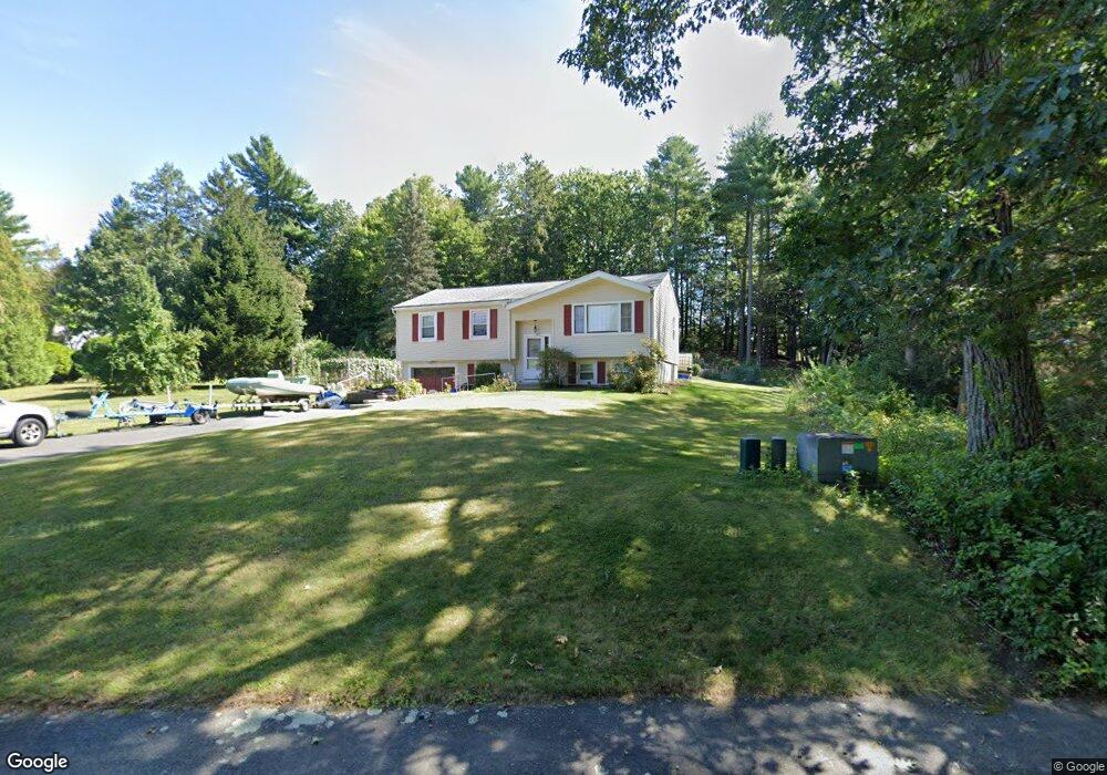
128 Logtown Rd Amherst, MA 01002
Estimated Value: $420,368 - $516,000
5
Beds
2
Baths
1,132
Sq Ft
$401/Sq Ft
Est. Value
About This Home
This home is located at 128 Logtown Rd, Amherst, MA 01002 and is currently estimated at $454,342, approximately $401 per square foot. 128 Logtown Rd is a home located in Hampshire County with nearby schools including Fort River Elementary School, Amherst Regional Middle School, and Amherst Regional High School.
Ownership History
Date
Name
Owned For
Owner Type
Purchase Details
Closed on
Jun 16, 2003
Sold by
Mao Siem and Chbam Sim
Bought by
Western Dev Corp
Current Estimated Value
Create a Home Valuation Report for This Property
The Home Valuation Report is an in-depth analysis detailing your home's value as well as a comparison with similar homes in the area
Home Values in the Area
Average Home Value in this Area
Purchase History
| Date | Buyer | Sale Price | Title Company |
|---|---|---|---|
| Western Dev Corp | $111,000 | -- |
Source: Public Records
Mortgage History
| Date | Status | Borrower | Loan Amount |
|---|---|---|---|
| Open | Western Dev Corp | $196,000 | |
| Previous Owner | Western Dev Corp | $100,000 | |
| Previous Owner | Western Dev Corp | $5,000 |
Source: Public Records
Tax History
| Year | Tax Paid | Tax Assessment Tax Assessment Total Assessment is a certain percentage of the fair market value that is determined by local assessors to be the total taxable value of land and additions on the property. | Land | Improvement |
|---|---|---|---|---|
| 2025 | $67 | $370,600 | $160,200 | $210,400 |
| 2024 | $6,473 | $349,700 | $151,200 | $198,500 |
| 2023 | $6,068 | $301,900 | $137,600 | $164,300 |
| 2022 | $5,779 | $271,700 | $125,000 | $146,700 |
| 2021 | $5,499 | $252,000 | $115,800 | $136,200 |
| 2020 | $5,373 | $252,000 | $115,800 | $136,200 |
| 2019 | $5,232 | $240,000 | $115,800 | $124,200 |
| 2018 | $5,074 | $240,000 | $115,800 | $124,200 |
| 2017 | $5,252 | $240,600 | $110,400 | $130,200 |
| 2016 | $5,106 | $240,600 | $110,400 | $130,200 |
| 2015 | $4,942 | $240,600 | $110,400 | $130,200 |
Source: Public Records
Map
Nearby Homes
- 27 Summerfield Rd
- 36 Trillium Way
- 148 Aubinwood Rd
- 130 Linden Ridge Rd
- 100 Larkspur Dr
- 0 Heatherstone Rd
- 23 Alyssum Dr
- 494 Station Rd
- 0 Amherst Rd
- 9 Harkness Rd
- 20 Station Rd
- 916 S East St
- 6 Eveningstar Dr
- 390 Shays St
- LOT 3 Harkness Rd
- 104 Spring St
- 252 West St Unit 13
- 0 Red Gate Ln Unit 73348273
- 0 Main St
- 32 N Prospect St Unit 5
- 132 Logtown Rd
- 1 Dwight Cir
- 126 Logtown Rd
- 136 Logtown Rd
- 5 Dwight Cir
- 127 Logtown Rd
- 123 Logtown Rd
- 135 Logtown Rd
- 140 Logtown Rd
- 9 Dwight Cir
- 137 Logtown Rd
- 2 Dwight Cir
- 2 Edgehill Place
- 124 Logtown Rd
- 4 Dwight Cir
- 4 Edge Hill Rd
- 2 Edge Hill Rd
- 144 Logtown Rd
- 143 Logtown Rd
- 120 Logtown Rd Unit 122
Your Personal Tour Guide
Ask me questions while you tour the home.