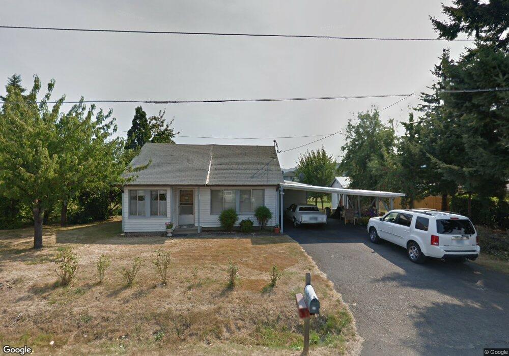
128 Miller St Sutherlin, OR 97479
Estimated Value: $174,099
4
Beds
1
Bath
2,424
Sq Ft
$72/Sq Ft
Est. Value
About This Home
This home is located at 128 Miller St, Sutherlin, OR 97479 and is currently estimated at $174,099, approximately $71 per square foot. 128 Miller St is a home located in Douglas County with nearby schools including East Sutherlin Primary School, West Sutherlin Intermediate School, and Sutherlin Middle School.
Ownership History
Date
Name
Owned For
Owner Type
Purchase Details
Closed on
Aug 11, 2016
Sold by
Western Oregon Conference Association Of
Bought by
Oliver Ronald W and Oliver Virginia L
Current Estimated Value
Purchase Details
Closed on
Apr 29, 2016
Sold by
Davis Brian L and Lloyd Brenda L
Bought by
Davis Brian L and Lloyd Brenda L
Purchase Details
Closed on
Sep 10, 2015
Sold by
Western Oregon Conference Association F
Bought by
Western Oregon Conference Association Of
Create a Home Valuation Report for This Property
The Home Valuation Report is an in-depth analysis detailing your home's value as well as a comparison with similar homes in the area
Home Values in the Area
Average Home Value in this Area
Purchase History
| Date | Buyer | Sale Price | Title Company |
|---|---|---|---|
| Oliver Ronald W | $100,000 | Ticor Title | |
| Davis Brian L | -- | None Available | |
| Western Oregon Conference Association Of | -- | None Available |
Source: Public Records
Tax History Compared to Growth
Tax History
| Year | Tax Paid | Tax Assessment Tax Assessment Total Assessment is a certain percentage of the fair market value that is determined by local assessors to be the total taxable value of land and additions on the property. | Land | Improvement |
|---|---|---|---|---|
| 2024 | $2,344 | $187,992 | -- | -- |
| 2023 | $2,277 | $182,517 | $0 | $0 |
| 2022 | $2,212 | $177,201 | $0 | $0 |
| 2021 | $2,148 | $172,040 | $0 | $0 |
| 2020 | $2,085 | $167,030 | $0 | $0 |
| 2019 | $2,025 | $162,166 | $0 | $0 |
| 2018 | $1,965 | $157,443 | $0 | $0 |
| 2017 | $2,010 | $152,858 | $0 | $0 |
| 2016 | $1,951 | $148,406 | $0 | $0 |
| 2015 | $1,900 | $144,084 | $0 | $0 |
| 2014 | $1,844 | $139,888 | $0 | $0 |
| 2013 | -- | $135,814 | $0 | $0 |
Source: Public Records
Map
Nearby Homes
- 226 Miller St
- 220 Miller St
- 279 Grant St
- 165 Robinson St
- 1223 Duke Ave
- 530 Tanglewood St
- 0 N Fourth St Unit 24557651
- 1386 Airway Ave
- 165 Valley Ct
- 409 S State St
- 427 S State St
- 0 Dakota St Unit B 500248401
- 819 S Comstock Ave Unit 13
- 181 SW Hutchins St
- 420 Backwater Loop
- 1688 W Central Ave
- 1660 Scardi Blvd
- 788 Schoon Mountain Rd
- 851 S Comstock Rd
- 1716 Scardi Blvd Unit 174
- 910 W Central Ave Unit 1
- 910 W Central Ave
- 132 Miller St
- 131 S Miller
- 131 Miller St
- 135 Miller St
- 0 Miller St
- 822 W Central Ave
- 136 Miller St
- 865 W Central Ave
- 948 W Central Ave
- 875 W Central Ave Unit 1
- 875 W Central Ave
- 137 Miller St
- 868 W First Ave Unit A
- 831 W Dean Ave
- 139 Miller St
- 140 Miller St
- 141 Miller St
- 142 Taylor Rd