Estimated Value: $67,000 - $116,000
Studio
--
Bath
864
Sq Ft
$95/Sq Ft
Est. Value
About This Home
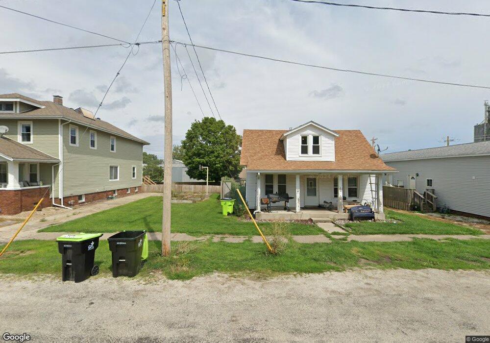
This home is located at 128 N Walnut St, Maroa, IL 61756 and is currently estimated at $81,660, approximately $94 per square foot. 128 N Walnut St is a home located in Macon County with nearby schools including Maroa-Forsyth Grade School, Maroa-Forsyth Middle School, and Maroa-Forsyth Senior High School.
Ownership History
Date
Name
Owned For
Owner Type
Purchase Details
Closed on
Jun 27, 2022
Sold by
Thomas Richard Lynn and Thomas Dawn Lee
Bought by
Fenton Kari M
Current Estimated Value
Purchase Details
Closed on
Mar 7, 2001
Sold by
Mckee Dennis L and Thomas Mckee Patricia A
Bought by
Thomas Richard Lynn and Thomas Dawn Lee
Home Financials for this Owner
Home Financials are based on the most recent Mortgage that was taken out on this home.
Original Mortgage
$45,800
Interest Rate
6.42%
Mortgage Type
New Conventional
Purchase Details
Closed on
Mar 1, 2001
Home Financials for this Owner
Home Financials are based on the most recent Mortgage that was taken out on this home.
Original Mortgage
$45,800
Interest Rate
6.42%
Mortgage Type
New Conventional
Create a Home Valuation Report for This Property
The Home Valuation Report is an in-depth analysis detailing your home's value as well as a comparison with similar homes in the area
Purchase History
| Date | Buyer | Sale Price | Title Company |
|---|---|---|---|
| Fenton Kari M | $35,000 | Hammer Kevin | |
| Thomas Richard Lynn | $550,000 | None Available | |
| -- | $55,000 | -- |
Source: Public Records
Mortgage History
| Date | Status | Borrower | Loan Amount |
|---|---|---|---|
| Previous Owner | Thomas Richard Lynn | $45,800 |
Source: Public Records
Tax History
| Year | Tax Paid | Tax Assessment Tax Assessment Total Assessment is a certain percentage of the fair market value that is determined by local assessors to be the total taxable value of land and additions on the property. | Land | Improvement |
|---|---|---|---|---|
| 2024 | $1,853 | $26,294 | $3,398 | $22,896 |
| 2023 | $1,709 | $24,432 | $3,157 | $21,275 |
| 2022 | $1,588 | $23,047 | $2,978 | $20,069 |
| 2021 | $1,510 | $21,891 | $2,829 | $19,062 |
| 2020 | $1,352 | $20,629 | $2,666 | $17,963 |
| 2019 | $1,352 | $20,629 | $2,666 | $17,963 |
| 2018 | $1,279 | $20,140 | $2,603 | $17,537 |
| 2017 | $1,341 | $20,225 | $2,614 | $17,611 |
| 2016 | $1,337 | $20,201 | $2,611 | $17,590 |
| 2015 | $1,148 | $19,613 | $2,535 | $17,078 |
| 2014 | $1,106 | $19,419 | $2,510 | $16,909 |
| 2013 | $1,117 | $19,419 | $2,510 | $16,909 |
Source: Public Records
Map
Nearby Homes
- 227 N Walnut St
- 108 N Locust St
- 116 S Maple St
- 214 N Maple St
- 2420 Lillian
- 2460 Lillian
- 2490 Lillian
- 2440 Lillian
- 2480 Lillian
- 8000 Gash Bridge Rd
- 3557 E Wise Rd
- 0 Betty Ln Unit 10514801
- 545 W Forsyth Rd
- 151 S Elwood St
- 247 S Grant St
- 5000 Silverado Ln
- 760 W Forsyth Pkwy
- 66 Holiday Dr
- 3 Delmar Dr
- 332 E Cox St
- 124 N Walnut St
- 132 N Walnut St
- 111 N Hickory St
- 129 N Walnut St
- 137 N Walnut St
- 121 N Walnut St
- 203 E Washington St
- 109 E Main St
- 201 N Walnut St
- 201 E Main St
- 215 E Washington St
- 107 N Walnut St
- 214 N Walnut St
- 109 W Main St
- 109 W Main St Unit 3D
- 109 W Main St Unit 4E
- 111 W Washington St
- 211 N Walnut St
- 132 N Wood St
- 114 E Main St
Your Personal Tour Guide
Ask me questions while you tour the home.