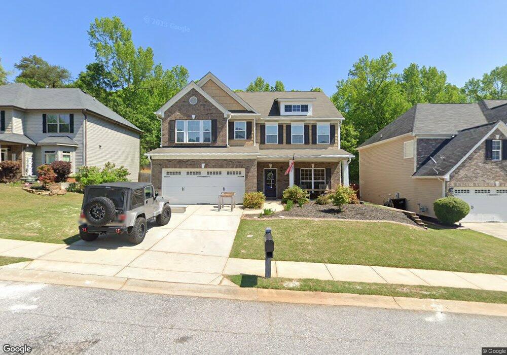
128 Open Range Ln Simpsonville, SC 29681
Estimated Value: $429,000 - $441,000
4
Beds
3
Baths
3,048
Sq Ft
$142/Sq Ft
Est. Value
About This Home
This home is located at 128 Open Range Ln, Simpsonville, SC 29681 and is currently estimated at $433,822, approximately $142 per square foot. 128 Open Range Ln is a home located in Greenville County with nearby schools including Bryson Elementary School, Bryson Middle School, and Hillcrest High School.
Ownership History
Date
Name
Owned For
Owner Type
Purchase Details
Closed on
Mar 20, 2009
Sold by
Mccar Homes Greenville Llc
Bought by
Goodwin Brian Joseph and Goodwin Mary Elizabeth
Current Estimated Value
Home Financials for this Owner
Home Financials are based on the most recent Mortgage that was taken out on this home.
Original Mortgage
$167,176
Outstanding Balance
$104,464
Interest Rate
5.13%
Mortgage Type
Purchase Money Mortgage
Estimated Equity
$329,358
Purchase Details
Closed on
Oct 30, 2008
Sold by
Tuley & Tuley Inc
Bought by
Mccar Homes Greenville Llc
Create a Home Valuation Report for This Property
The Home Valuation Report is an in-depth analysis detailing your home's value as well as a comparison with similar homes in the area
Home Values in the Area
Average Home Value in this Area
Purchase History
| Date | Buyer | Sale Price | Title Company |
|---|---|---|---|
| Goodwin Brian Joseph | $208,970 | -- | |
| Mccar Homes Greenville Llc | $248,590 | -- |
Source: Public Records
Mortgage History
| Date | Status | Borrower | Loan Amount |
|---|---|---|---|
| Open | Goodwin Brian Joseph | $167,176 |
Source: Public Records
Tax History
| Year | Tax Paid | Tax Assessment Tax Assessment Total Assessment is a certain percentage of the fair market value that is determined by local assessors to be the total taxable value of land and additions on the property. | Land | Improvement |
|---|---|---|---|---|
| 2025 | $2,127 | $11,920 | $2,710 | $9,210 |
| 2024 | $2,127 | $10,360 | $1,520 | $8,840 |
| 2023 | $2,047 | $10,360 | $1,520 | $8,840 |
| 2022 | $1,999 | $10,360 | $1,520 | $8,840 |
| 2021 | $2,000 | $10,360 | $1,520 | $8,840 |
| 2020 | $1,904 | $9,250 | $1,160 | $8,090 |
| 2019 | $1,905 | $9,250 | $1,160 | $8,090 |
| 2018 | $1,768 | $9,250 | $1,160 | $8,090 |
| 2017 | $1,768 | $9,250 | $1,160 | $8,090 |
| 2016 | $1,701 | $231,090 | $28,880 | $202,210 |
| 2015 | $1,701 | $231,090 | $28,880 | $202,210 |
| 2014 | $1,461 | $200,950 | $33,000 | $167,950 |
Source: Public Records
Map
Nearby Homes
- 607 Raleighwood Ln
- 1024 Powderhorn Rd
- 129 Morning Tide Dr
- 389 Heritage Point Dr
- 33 Golden Acre Ct
- 300 Raleighwood Ln
- 215 Chickamauga Ln
- 231 Raleighwood Ln
- 527 Baycraft Ln
- 14 Corsica Ct
- 2 Durbin Forest Way
- 7 Durbin Forest Way
- 106 Ashborne Ln
- 202 Ashborne Ln
- 3 Snader Cir
- 501 Baycraft Ln
- 110 Bonwood Ave
- 6 Ashborne Ln
- 104 Plain Post Trail
- 108 Plain Post Trail
- 128 Open Range Ln Unit HK40
- 127 Open Range Ln Unit HK167
- 132 Open Range Ln
- 124 Open Range Ln Unit HK041
- 124 Open Range Ln
- 200 Open Range Ln
- 120 Open Range Ln
- 278 Oak Branch Dr
- 204 Open Range Ln
- 216 Appomattox Dr
- 276 Oak Branch Dr
- 212 Appomattox Dr
- 208 Open Range Ln
- 208 Open Range Ln
- 279 Oak Branch Dr Unit Heritage Creek 35
- 279 Oak Branch Dr
- 210 Appomattox Dr
- 274 Oak Branch Dr
- 218 Appomattox Dr
- 277 Oak Branch Dr
Your Personal Tour Guide
Ask me questions while you tour the home.