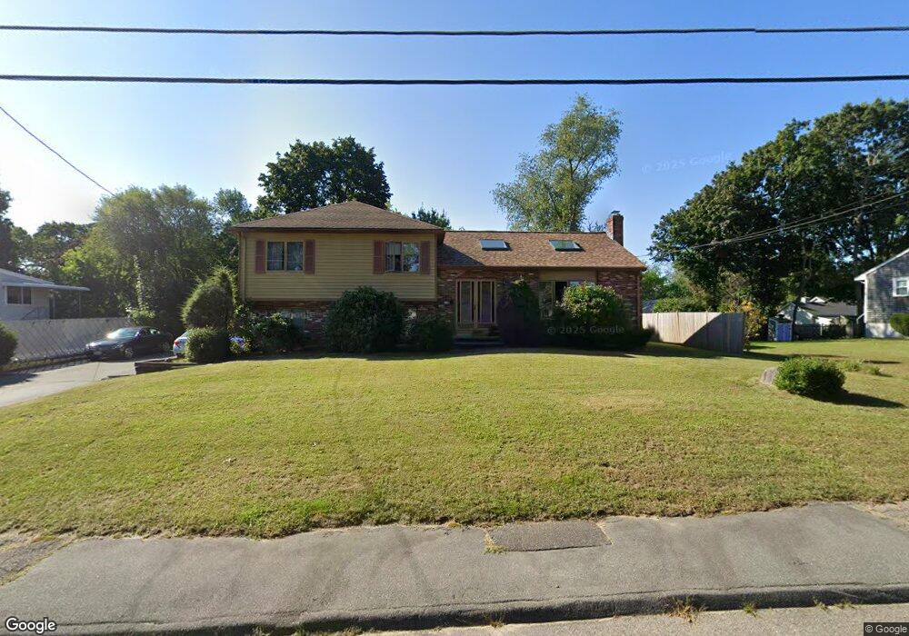
128 Roberts Ave Holbrook, MA 02343
Estimated Value: $603,976 - $670,000
4
Beds
2
Baths
1,926
Sq Ft
$334/Sq Ft
Est. Value
About This Home
This home is located at 128 Roberts Ave, Holbrook, MA 02343 and is currently estimated at $643,994, approximately $334 per square foot. 128 Roberts Ave is a home located in Norfolk County with nearby schools including John F. Kennedy Elementary School, Holbrook Middle High School, and Boston Higashi School.
Ownership History
Date
Name
Owned For
Owner Type
Purchase Details
Closed on
Dec 22, 2019
Sold by
Taylor Rufus L and Taylor Sarah F
Bought by
Taylor Ft and Hampton
Current Estimated Value
Purchase Details
Closed on
Jun 20, 1984
Bought by
Taylor Rufus L and Taylor Sarah E
Create a Home Valuation Report for This Property
The Home Valuation Report is an in-depth analysis detailing your home's value as well as a comparison with similar homes in the area
Home Values in the Area
Average Home Value in this Area
Purchase History
| Date | Buyer | Sale Price | Title Company |
|---|---|---|---|
| Taylor Ft | -- | None Available | |
| Taylor Ft | -- | None Available | |
| Taylor Rufus L | $109,900 | -- |
Source: Public Records
Mortgage History
| Date | Status | Borrower | Loan Amount |
|---|---|---|---|
| Previous Owner | Taylor Rufus L | $121,000 | |
| Previous Owner | Taylor Rufus L | $116,923 | |
| Previous Owner | Taylor Rufus L | $108,000 |
Source: Public Records
Tax History Compared to Growth
Tax History
| Year | Tax Paid | Tax Assessment Tax Assessment Total Assessment is a certain percentage of the fair market value that is determined by local assessors to be the total taxable value of land and additions on the property. | Land | Improvement |
|---|---|---|---|---|
| 2025 | $6,995 | $530,700 | $219,600 | $311,100 |
| 2024 | $6,803 | $506,200 | $199,600 | $306,600 |
| 2023 | $7,224 | $469,700 | $181,500 | $288,200 |
| 2022 | $6,509 | $394,700 | $157,800 | $236,900 |
| 2021 | $6,463 | $375,300 | $147,500 | $227,800 |
| 2020 | $6,663 | $362,700 | $140,400 | $222,300 |
| 2019 | $6,494 | $333,700 | $125,100 | $208,600 |
| 2018 | $6,354 | $307,400 | $106,100 | $201,300 |
| 2017 | $6,270 | $300,000 | $106,100 | $193,900 |
| 2016 | $6,024 | $306,700 | $118,200 | $188,500 |
| 2015 | $5,611 | $294,100 | $111,100 | $183,000 |
| 2014 | $5,227 | $278,500 | $101,000 | $177,500 |
Source: Public Records
Map
Nearby Homes
- 63 Cedarhill Rd
- 5 Clarendon Cir Unit Lot 4
- 27 Winter St
- 7 Morton Rd
- 46 Wilmarth Rd
- 327 Union St
- 229 Mill St
- 217 Mill St
- 148 N Franklin St
- 346 South St
- 58 Chandler St
- 314 South St
- 5 Patterson Ave E
- 187 Belcher St
- 10 Alfred Terrace
- 276 Center St
- 152 S Franklin St
- 373 N Franklin St
- 40 Overlook Rd
- 4 Evan Cain Way
- 126 Roberts Ave
- 130 Roberts Ave
- 47 Mount Pleasant Ave
- 113 Roberts Ave
- 45 Mount Pleasant Ave
- 51 Mount Pleasant Ave
- 111 Roberts Ave
- 115 Roberts Ave
- 124 Roberts Ave
- 132 Roberts Ave
- 48 Mount Pleasant Ave
- 52 Mount Pleasant Ave
- 109 Roberts Ave
- 117 Roberts Ave
- 44 Mount Pleasant Ave
- 39 Mount Pleasant Ave
- 56 Mount Pleasant Ave
- 55 Mount Pleasant Ave
- 120 Roberts Ave
- 134 Roberts Ave