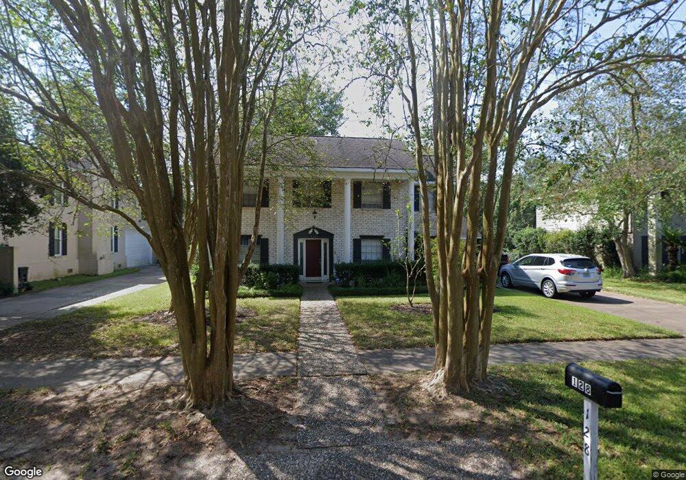
128 Saint Andrews Dr Friendswood, TX 77546
Estimated Value: $357,154 - $391,000
4
Beds
3
Baths
2,544
Sq Ft
$149/Sq Ft
Est. Value
About This Home
This home is located at 128 Saint Andrews Dr, Friendswood, TX 77546 and is currently estimated at $378,539, approximately $148 per square foot. 128 Saint Andrews Dr is a home located in Galveston County with nearby schools including C.W. Cline Elementary School, Windsong Elementary School, and Friendswood Junior High School.
Ownership History
Date
Name
Owned For
Owner Type
Purchase Details
Closed on
Apr 21, 2004
Sold by
Engelhardt Jocelyn M
Bought by
Sluder Kevin R and Sluder Cheryl
Current Estimated Value
Home Financials for this Owner
Home Financials are based on the most recent Mortgage that was taken out on this home.
Original Mortgage
$110,250
Outstanding Balance
$61,496
Interest Rate
8.4%
Mortgage Type
New Conventional
Estimated Equity
$317,043
Purchase Details
Closed on
Dec 1, 2003
Sold by
Engelhardt James K
Bought by
Engelhardts Jocelyn M
Create a Home Valuation Report for This Property
The Home Valuation Report is an in-depth analysis detailing your home's value as well as a comparison with similar homes in the area
Home Values in the Area
Average Home Value in this Area
Purchase History
| Date | Buyer | Sale Price | Title Company |
|---|---|---|---|
| Sluder Kevin R | -- | American Title Co | |
| Engelhardts Jocelyn M | -- | -- |
Source: Public Records
Mortgage History
| Date | Status | Borrower | Loan Amount |
|---|---|---|---|
| Open | Sluder Kevin R | $110,250 | |
| Closed | Sluder Kevin R | $14,500 |
Source: Public Records
Tax History Compared to Growth
Tax History
| Year | Tax Paid | Tax Assessment Tax Assessment Total Assessment is a certain percentage of the fair market value that is determined by local assessors to be the total taxable value of land and additions on the property. | Land | Improvement |
|---|---|---|---|---|
| 2025 | $4,878 | $350,790 | $51,420 | $299,370 |
| 2024 | $4,878 | $325,328 | -- | -- |
| 2023 | $4,878 | $295,753 | $0 | $0 |
| 2022 | $5,922 | $268,866 | $0 | $0 |
| 2021 | $5,709 | $311,010 | $51,420 | $259,590 |
| 2020 | $5,353 | $257,930 | $51,420 | $206,510 |
| 2019 | $5,129 | $220,280 | $27,570 | $192,710 |
| 2018 | $4,691 | $183,640 | $27,570 | $156,070 |
| 2017 | $4,941 | $225,090 | $27,570 | $197,520 |
| 2016 | $4,492 | $198,330 | $27,570 | $170,760 |
| 2015 | $1,428 | $180,790 | $27,570 | $153,220 |
| 2014 | $1,345 | $142,950 | $27,570 | $115,380 |
Source: Public Records
Map
Nearby Homes
- 251 Saint Cloud Dr
- 110 Dorado Dr
- Amalfi Plan at Friendswood Trails
- Portofino Plan at Friendswood Trails
- Postiano Plan at Friendswood Trails
- Capri Plan at Friendswood Trails
- Ravello Plan at Friendswood Trails
- 2512 Ravenna Ct
- 1508 Harvest Vine Ct
- 2829 Fairway Dr
- 2904 Bridle Path Ln
- 1607 Orlando St
- 2847 Everett Dr
- 40 Windsong Ln
- 601 E Castle Harbour Dr
- 2605 S Mission Cir
- 644 E Castle Harbour Dr
- 2211 S Mission Cir
- 2082 Wilderness Trail
- 1913 Lundy Ln
- 132 Saint Andrews Dr
- 124 Saint Andrews Dr
- 120 Saint Andrews Dr
- 136 Saint Andrews Dr
- 217 Saint Cloud Dr
- 213 Saint Cloud Dr
- 221 Saint Cloud Dr
- 129 Saint Andrews Dr
- 209 Saint Cloud Dr
- 140 Saint Andrews Dr
- 121 Saint Andrews Dr
- 116 Saint Andrews Dr
- 133 Saint Andrews Dr
- 225 Saint Cloud Dr
- 205 Saint Cloud Dr
- 117 Saint Andrews Dr
- 137 Saint Andrews Dr
- 144 Saint Andrews Dr
- 229 Saint Cloud Dr
- 112 Saint Andrews Dr