Estimated Value: $183,128 - $216,000
3
Beds
2
Baths
1,776
Sq Ft
$115/Sq Ft
Est. Value
About This Home
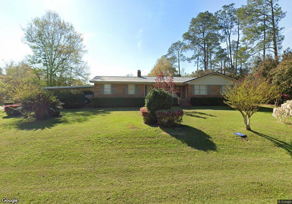
This home is located at 1280 Brookwood Dr SE, Cairo, GA 39828 and is currently estimated at $204,782, approximately $115 per square foot. 1280 Brookwood Dr SE is a home located in Grady County with nearby schools including Cairo High School.
Ownership History
Date
Name
Owned For
Owner Type
Purchase Details
Closed on
Mar 10, 2022
Sold by
Johnson Lynn C
Bought by
Johnson W Reese
Current Estimated Value
Purchase Details
Closed on
Nov 16, 2005
Sold by
Johnson W Reese
Bought by
Johnson Lynn C
Purchase Details
Closed on
Mar 28, 2002
Sold by
Bryant Travis Joshua
Bought by
Mcevoy Richard A
Purchase Details
Closed on
Jan 28, 2000
Sold by
Johnson W Reese
Bought by
Bryant Travis Joshua
Purchase Details
Closed on
Jul 25, 1989
Bought by
Johnson W Reese
Create a Home Valuation Report for This Property
The Home Valuation Report is an in-depth analysis detailing your home's value as well as a comparison with similar homes in the area
Home Values in the Area
Average Home Value in this Area
Purchase History
| Date | Buyer | Sale Price | Title Company |
|---|---|---|---|
| Johnson W Reese | -- | -- | |
| Johnson Lynn C | -- | -- | |
| Mcevoy Richard A | $85,000 | -- | |
| Bryant Travis Joshua | $80,600 | -- | |
| Johnson W Reese | $55,500 | -- |
Source: Public Records
Tax History Compared to Growth
Tax History
| Year | Tax Paid | Tax Assessment Tax Assessment Total Assessment is a certain percentage of the fair market value that is determined by local assessors to be the total taxable value of land and additions on the property. | Land | Improvement |
|---|---|---|---|---|
| 2024 | $2,520 | $65,425 | $6,000 | $59,425 |
| 2023 | $1,882 | $52,512 | $6,000 | $46,512 |
| 2022 | $1,960 | $52,512 | $6,000 | $46,512 |
| 2021 | $1,965 | $52,512 | $6,000 | $46,512 |
| 2020 | $1,971 | $52,512 | $6,000 | $46,512 |
| 2019 | $1,722 | $46,086 | $6,000 | $40,086 |
| 2018 | $1,637 | $46,086 | $6,000 | $40,086 |
| 2017 | $1,575 | $46,086 | $6,000 | $40,086 |
| 2016 | $1,371 | $39,422 | $6,000 | $33,422 |
| 2015 | $1,357 | $39,422 | $6,000 | $33,422 |
| 2014 | $1,357 | $39,422 | $6,000 | $33,422 |
| 2013 | -- | $38,137 | $12,000 | $26,137 |
Source: Public Records
Map
Nearby Homes
- 309 Midland Place
- 1310 Brookwood Dr SE
- 1236 Brookwood Dr SE
- 1259 Brookwood Dr SE
- 1299 Brookwood Dr SE
- 1249 Brookwood Dr SE
- 1311 Brookwood Dr SE
- 305 Horseshoe Bend
- 307 Midland Place
- 1107 Brookwood Dr SE
- 1321 Brookwood Dr SE
- 306 Midland Place
- 1332 Brookwood Dr SE
- 351 Horseshoe Bend
- 305 Midland Place
- 304 Midland Place
- 302 Horseshoe Bend
- 302 Horseshoe Bend
- 1104 Brookwood Dr SE
- 111246 N Downs Bend NE