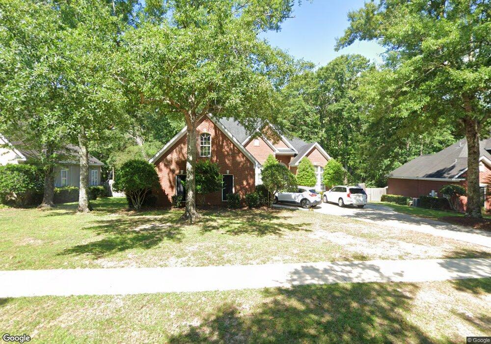
1280 Cameron Dr Unit 2 Mobile, AL 36695
Sheldon NeighborhoodEstimated Value: $359,000 - $409,000
4
Beds
3
Baths
2,812
Sq Ft
$133/Sq Ft
Est. Value
About This Home
This home is located at 1280 Cameron Dr Unit 2, Mobile, AL 36695 and is currently estimated at $374,816, approximately $133 per square foot. 1280 Cameron Dr Unit 2 is a home located in Mobile County with nearby schools including ER Dickson Elementary School, Bernice J Causey Middle School, and WP Davidson High School.
Ownership History
Date
Name
Owned For
Owner Type
Purchase Details
Closed on
Aug 22, 2003
Sold by
Southland Capital Lp
Bought by
Regan Richard J and Regan Paige P
Current Estimated Value
Home Financials for this Owner
Home Financials are based on the most recent Mortgage that was taken out on this home.
Original Mortgage
$221,600
Outstanding Balance
$98,293
Interest Rate
5.72%
Mortgage Type
Unknown
Estimated Equity
$276,523
Purchase Details
Closed on
Aug 30, 2000
Sold by
Hamilton Homes & Construction Co Inc
Bought by
Mcdavid R Neil and Mcdavid Georgia Araminta
Home Financials for this Owner
Home Financials are based on the most recent Mortgage that was taken out on this home.
Original Mortgage
$277,100
Interest Rate
8.24%
Purchase Details
Closed on
May 31, 2000
Sold by
Terrell Butts Lawrence and Butts Debra
Bought by
Hamilton Homes & Construction Co Inc
Create a Home Valuation Report for This Property
The Home Valuation Report is an in-depth analysis detailing your home's value as well as a comparison with similar homes in the area
Home Values in the Area
Average Home Value in this Area
Purchase History
| Date | Buyer | Sale Price | Title Company |
|---|---|---|---|
| Regan Richard J | -- | -- | |
| Mcdavid R Neil | -- | Surety Land Title Inc | |
| Hamilton Homes & Construction Co Inc | -- | -- |
Source: Public Records
Mortgage History
| Date | Status | Borrower | Loan Amount |
|---|---|---|---|
| Open | Regan Richard J | $221,600 | |
| Previous Owner | Mcdavid R Neil | $277,100 |
Source: Public Records
Tax History
| Year | Tax Paid | Tax Assessment Tax Assessment Total Assessment is a certain percentage of the fair market value that is determined by local assessors to be the total taxable value of land and additions on the property. | Land | Improvement |
|---|---|---|---|---|
| 2025 | $1,470 | $31,470 | $4,950 | $26,520 |
| 2024 | $1,470 | $30,460 | $4,500 | $25,960 |
| 2023 | $1,420 | $28,870 | $4,500 | $24,370 |
| 2022 | $1,365 | $29,520 | $4,500 | $25,020 |
| 2021 | $1,292 | $28,020 | $4,500 | $23,520 |
| 2020 | $1,307 | $28,320 | $4,500 | $23,820 |
| 2019 | $1,321 | $28,620 | $0 | $0 |
| 2018 | $1,336 | $28,920 | $0 | $0 |
| 2017 | $1,437 | $31,000 | $0 | $0 |
| 2016 | $1,451 | $31,300 | $0 | $0 |
| 2013 | $1,503 | $29,480 | $0 | $0 |
Source: Public Records
Map
Nearby Homes
- 7601 Cameron Ct
- 1337 Carson Rd W
- 1291 Carson Rd W
- 7693 Pembroke Cir
- 1171 Newbury Ln E
- 1542 Stone Hedge Dr W
- 1130 Jonathan Ct
- 1361 Dellwyn Ct
- 1484 Pebble Creek Dr
- 1000 Choctaw Bluff Rd
- 8621 Grelot Rd
- 1630 Ashmoor Dr E
- 836 Willow Bridge Dr W
- 1263 Smithfield Rd E
- 816 Willow Springs Dr
- 1735 Ashmoor Dr W
- 1350 A Schillinger Rd S
- 1350 Schillinger Rd S
- 7485 Creekwood Dr
- 8050 Saint Jude Cir N
- 1270 Cameron Dr
- 1290 Cameron Dr
- 1320 Cameron Dr
- 1285 Cameron Dr
- 0 Cameron Dr Unit 20
- 0 Court
- 33 Pembroke Cir
- 1330 Cameron Dr
- 1250 Cameron Dr
- 1240 Copley Cir
- 7611 Cameron Ct
- 7620 Cameron Ct
- 1240 Cameron Dr Unit 2
- 1250 Copley Cir
- 1340 Cameron Dr
- 7632 Pembroke Cir
- 1230 Copley Cir
- 1290 Carson Rd W
- 1324 Carson Rd W
- 1336 Carson Rd W
Your Personal Tour Guide
Ask me questions while you tour the home.