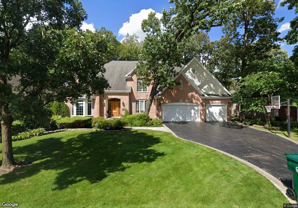
1280 Ridge Rd Northbrook, IL 60062
Estimated Value: $1,547,000 - $1,833,000
5
Beds
5
Baths
4,425
Sq Ft
$374/Sq Ft
Est. Value
About This Home
This home is located at 1280 Ridge Rd, Northbrook, IL 60062 and is currently estimated at $1,656,040, approximately $374 per square foot. 1280 Ridge Rd is a home located in Cook County with nearby schools including Meadowbrook Elementary School, Northbrook Junior High School, and Glenbrook North High School.
Ownership History
Date
Name
Owned For
Owner Type
Purchase Details
Closed on
Jul 14, 2015
Sold by
Fischer John W and Fischer Carol S
Bought by
Cohen Richard I and Cohen Jocelyn W
Current Estimated Value
Home Financials for this Owner
Home Financials are based on the most recent Mortgage that was taken out on this home.
Original Mortgage
$950,000
Outstanding Balance
$724,891
Interest Rate
3.5%
Mortgage Type
New Conventional
Estimated Equity
$931,149
Purchase Details
Closed on
Jun 27, 1997
Sold by
The Krupa Companies Ltd
Bought by
Fischer John W and Fischer Carol S
Home Financials for this Owner
Home Financials are based on the most recent Mortgage that was taken out on this home.
Original Mortgage
$40,000
Interest Rate
8%
Purchase Details
Closed on
Aug 22, 1996
Sold by
Remahl Daniel F and Remahl Susan M
Bought by
The Krupa Companies Ltd
Create a Home Valuation Report for This Property
The Home Valuation Report is an in-depth analysis detailing your home's value as well as a comparison with similar homes in the area
Home Values in the Area
Average Home Value in this Area
Purchase History
| Date | Buyer | Sale Price | Title Company |
|---|---|---|---|
| Cohen Richard I | $1,299,000 | Ct | |
| Fischer John W | $720,000 | -- | |
| The Krupa Companies Ltd | $244,000 | -- |
Source: Public Records
Mortgage History
| Date | Status | Borrower | Loan Amount |
|---|---|---|---|
| Open | Cohen Richard I | $950,000 | |
| Previous Owner | Fischer John W | $40,000 |
Source: Public Records
Tax History
| Year | Tax Paid | Tax Assessment Tax Assessment Total Assessment is a certain percentage of the fair market value that is determined by local assessors to be the total taxable value of land and additions on the property. | Land | Improvement |
|---|---|---|---|---|
| 2025 | $23,258 | $131,000 | $16,821 | $114,179 |
| 2024 | $23,258 | $97,970 | $15,620 | $82,350 |
| 2023 | $24,117 | $104,962 | $15,620 | $89,342 |
| 2022 | $24,117 | $112,085 | $15,620 | $96,465 |
| 2021 | $23,518 | $97,310 | $12,615 | $84,695 |
| 2020 | $23,925 | $100,673 | $12,615 | $88,058 |
| 2019 | $24,413 | $116,108 | $12,615 | $103,493 |
| 2018 | $19,682 | $87,356 | $11,113 | $76,243 |
| 2017 | $19,188 | $87,356 | $11,113 | $76,243 |
| 2016 | $20,644 | $98,551 | $11,113 | $87,438 |
| 2015 | $18,210 | $79,359 | $9,311 | $70,048 |
| 2014 | $17,401 | $79,359 | $9,311 | $70,048 |
| 2013 | $17,823 | $83,784 | $9,311 | $74,473 |
Source: Public Records
Map
Nearby Homes
- 1219 Ridgewood Dr
- 1135 Buttonwood Ln
- 1443 Woodhill Dr
- 1179 Shermer Rd
- 1209 Gateway Ct
- 1229 Shermer Rd
- 1233 Gateway Ct
- 1255 Shermer Rd
- 1444 Sycamore Ln
- 1443 Church St
- 34 Bridlewood Rd
- 1430 Voltz Rd
- 24 Bridlewood Rd
- 535 Fairway Ln
- 440 Lee Rd
- 1380 Rosemary Ln
- 1 Morrison Rd
- 1013 Longaker Rd
- 1914 Farnsworth Ln Unit 208
- 1914 Farnsworth Ln Unit 303
- 1266 Ridge Rd
- 1294 Ridge Rd
- 1236 Larrabee Ln
- 1250 Ridge Rd
- 1304 Ridge Rd
- 1181 Wendy Dr
- 1244 Larrabee Ln
- 1228 Larrabee Ln
- 1180 Daryl Ln
- 1220 Larrabee Ln
- 1300 Larrabee Ln
- 1234 Ridge Rd
- 1318 Ridge Rd
- 1201 Wendy Dr
- 1200 Daryl Ln
- 1180 Wendy Dr
- 1243 Eastwood Ln
- 1233 Ridge Rd
- 1306 Larrabee Ln
- 1212 Larrabee Ln
Your Personal Tour Guide
Ask me questions while you tour the home.