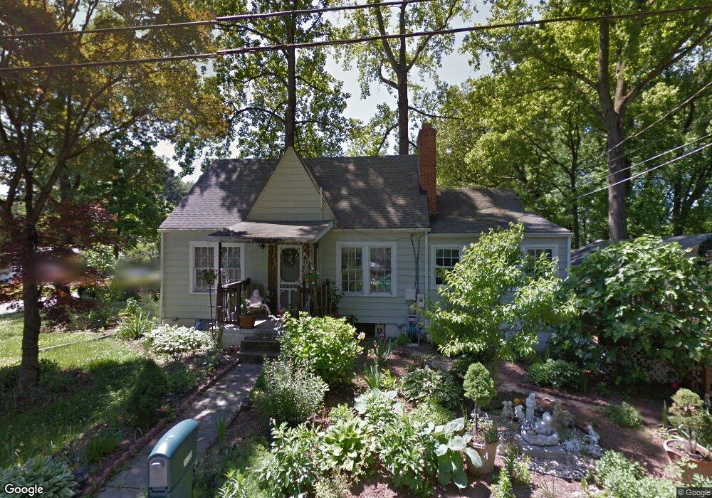
12800 Poplar St Silver Spring, MD 20904
Estimated Value: $431,000 - $516,000
--
Bed
2
Baths
1,212
Sq Ft
$389/Sq Ft
Est. Value
About This Home
This home is located at 12800 Poplar St, Silver Spring, MD 20904 and is currently estimated at $471,302, approximately $388 per square foot. 12800 Poplar St is a home located in Montgomery County with nearby schools including Cannon Road Elementary School, Mendon Middle/High School, and Manton Consolidated Middle School.
Ownership History
Date
Name
Owned For
Owner Type
Purchase Details
Closed on
Oct 25, 2000
Sold by
Hilderbrand Michael C
Bought by
Ramirez Gonzalo and Degado Maria L
Current Estimated Value
Purchase Details
Closed on
May 3, 1994
Sold by
Jacobs M E
Bought by
Hilderbrand Michael C
Home Financials for this Owner
Home Financials are based on the most recent Mortgage that was taken out on this home.
Original Mortgage
$129,250
Interest Rate
7.7%
Create a Home Valuation Report for This Property
The Home Valuation Report is an in-depth analysis detailing your home's value as well as a comparison with similar homes in the area
Home Values in the Area
Average Home Value in this Area
Purchase History
| Date | Buyer | Sale Price | Title Company |
|---|---|---|---|
| Ramirez Gonzalo | $170,000 | -- | |
| Hilderbrand Michael C | $133,000 | -- |
Source: Public Records
Mortgage History
| Date | Status | Borrower | Loan Amount |
|---|---|---|---|
| Previous Owner | Hilderbrand Michael C | $129,250 |
Source: Public Records
Tax History Compared to Growth
Tax History
| Year | Tax Paid | Tax Assessment Tax Assessment Total Assessment is a certain percentage of the fair market value that is determined by local assessors to be the total taxable value of land and additions on the property. | Land | Improvement |
|---|---|---|---|---|
| 2025 | $4,457 | $354,867 | -- | -- |
| 2024 | $4,457 | $334,433 | $0 | $0 |
| 2023 | $4,889 | $314,000 | $226,400 | $87,600 |
| 2022 | $2,531 | $314,000 | $226,400 | $87,600 |
| 2021 | $3,245 | $314,000 | $226,400 | $87,600 |
| 2020 | $4,671 | $333,100 | $226,400 | $106,700 |
| 2019 | $3,224 | $317,733 | $0 | $0 |
| 2018 | $3,035 | $302,367 | $0 | $0 |
| 2017 | $2,867 | $287,000 | $0 | $0 |
| 2016 | -- | $277,267 | $0 | $0 |
| 2015 | $2,950 | $267,533 | $0 | $0 |
| 2014 | $2,950 | $257,800 | $0 | $0 |
Source: Public Records
Map
Nearby Homes
- 605 Rosemere Ave
- 708 Hollywood Ave
- 605 Winhall Way
- 12814 Greenbriar St
- 12608 Norcross Ct
- 716 Downs Dr
- 12805 Broadmore Rd
- 12821 Baker Dr
- 7 Shaw Ave
- 12811 Tamarack Rd
- 13132 Kara Ln
- 13137 Broadmore Rd
- 713 Anderson St
- 12503 Meadowood Dr
- 1203 Brantford Ave
- 6 & 10 Vital Way
- 12509 White Dr
- 1415 Smith Village Rd
- 206 Shaw Ave
- 1407 Northcrest Dr
- 710 Rosemere Ave
- 800 Rosemere Ave
- 12805 Poplar St
- 708 Rosemere Ave
- 12806 Poplar St
- 12808 Poplar St
- 804 Rosemere Ave
- 12807 Poplar St
- 704 Rosemere Ave
- 713 Rosemere Ave
- 711 Rosemere Ave
- 801 Rosemere Ave
- 806 Rosemere Ave
- 801 Johnson Ave
- 709 Rosemere Ave
- 627 Eldrid Dr
- 803 Rosemere Ave
- 707 Rosemere Ave
- 805 Rosemere Ave
- 810 Rosemere Ave