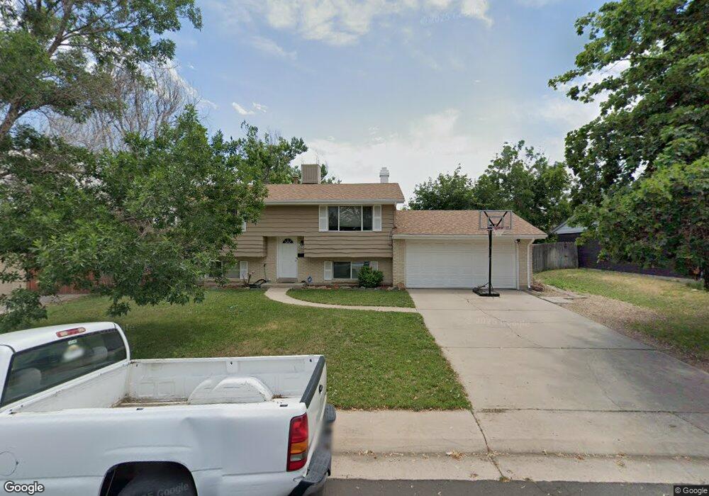
12813 E Nevada Cir Aurora, CO 80012
Aurora Hills NeighborhoodEstimated Value: $425,000 - $456,000
3
Beds
2
Baths
1,515
Sq Ft
$288/Sq Ft
Est. Value
About This Home
This home is located at 12813 E Nevada Cir, Aurora, CO 80012 and is currently estimated at $436,424, approximately $288 per square foot. 12813 E Nevada Cir is a home located in Arapahoe County with nearby schools including Virginia Court Elementary School, Aurora Hills Middle School, and Gateway High School.
Ownership History
Date
Name
Owned For
Owner Type
Purchase Details
Closed on
Dec 29, 2015
Sold by
Fitzpatrick Stephen William and Leveck Colleen
Bought by
Welsh Alan
Current Estimated Value
Home Financials for this Owner
Home Financials are based on the most recent Mortgage that was taken out on this home.
Original Mortgage
$212,480
Outstanding Balance
$167,287
Interest Rate
3.98%
Mortgage Type
New Conventional
Estimated Equity
$269,137
Purchase Details
Closed on
Mar 14, 2011
Sold by
Fitzpatrick Stephen William
Bought by
Fitzpatrick Stephen William and Leveck Colleen
Purchase Details
Closed on
Jun 4, 2010
Sold by
Ims Family Trust
Bought by
Fitzpatrick Stephen William
Home Financials for this Owner
Home Financials are based on the most recent Mortgage that was taken out on this home.
Original Mortgage
$169,569
Interest Rate
5%
Mortgage Type
VA
Purchase Details
Closed on
Jan 20, 2010
Sold by
Vongsakoun Khamphan
Bought by
Ims Family Trust
Purchase Details
Closed on
Apr 11, 2007
Sold by
Wells Fargo Bank Na
Bought by
Vongsakoun Khamphan
Home Financials for this Owner
Home Financials are based on the most recent Mortgage that was taken out on this home.
Original Mortgage
$119,920
Interest Rate
7.7%
Mortgage Type
Stand Alone First
Purchase Details
Closed on
May 27, 2005
Sold by
Burgess Robert
Bought by
Taylor Sandra
Home Financials for this Owner
Home Financials are based on the most recent Mortgage that was taken out on this home.
Original Mortgage
$40,400
Interest Rate
5.34%
Mortgage Type
Stand Alone Second
Purchase Details
Closed on
Sep 30, 2004
Sold by
Carnahan Keith P and Carnahan Stephanie L
Bought by
Burgess Robert
Home Financials for this Owner
Home Financials are based on the most recent Mortgage that was taken out on this home.
Original Mortgage
$125,000
Interest Rate
5.81%
Mortgage Type
Unknown
Purchase Details
Closed on
Jan 5, 1989
Sold by
Conversion Arapco
Bought by
Carnahan Keith P and Carnahan Stephanie L
Purchase Details
Closed on
May 1, 1977
Sold by
Conversion Arapco
Bought by
Conversion Arapco
Purchase Details
Closed on
Jul 4, 1776
Bought by
Conversion Arapco
Create a Home Valuation Report for This Property
The Home Valuation Report is an in-depth analysis detailing your home's value as well as a comparison with similar homes in the area
Home Values in the Area
Average Home Value in this Area
Purchase History
| Date | Buyer | Sale Price | Title Company |
|---|---|---|---|
| Welsh Alan | $265,600 | Chicago Title Co | |
| Fitzpatrick Stephen William | -- | None Available | |
| Fitzpatrick Stephen William | $166,000 | Stewart Title | |
| Ims Family Trust | $71,000 | Stewart Title | |
| Vongsakoun Khamphan | $149,900 | None Available | |
| Taylor Sandra | $202,000 | Quantum Title | |
| Burgess Robert | $125,000 | Title America | |
| Carnahan Keith P | -- | -- | |
| Conversion Arapco | -- | -- | |
| Conversion Arapco | -- | -- |
Source: Public Records
Mortgage History
| Date | Status | Borrower | Loan Amount |
|---|---|---|---|
| Open | Welsh Alan | $212,480 | |
| Previous Owner | Fitzpatrick Stephen William | $169,569 | |
| Previous Owner | Vongsakoun Khamphan | $119,920 | |
| Previous Owner | Taylor Sandra | $40,400 | |
| Previous Owner | Taylor Sandra | $161,600 | |
| Previous Owner | Burgess Robert | $125,000 |
Source: Public Records
Tax History
| Year | Tax Paid | Tax Assessment Tax Assessment Total Assessment is a certain percentage of the fair market value that is determined by local assessors to be the total taxable value of land and additions on the property. | Land | Improvement |
|---|---|---|---|---|
| 2025 | $2,903 | $28,125 | -- | -- |
| 2024 | $2,816 | $30,297 | -- | -- |
| 2023 | $2,816 | $30,297 | $0 | $0 |
| 2022 | $2,246 | $22,365 | $0 | $0 |
| 2021 | $2,318 | $22,365 | $0 | $0 |
| 2020 | $2,263 | $21,736 | $0 | $0 |
| 2019 | $2,251 | $21,736 | $0 | $0 |
| 2018 | $2,140 | $20,239 | $0 | $0 |
| 2017 | $1,862 | $20,239 | $0 | $0 |
| 2016 | $1,404 | $14,949 | $0 | $0 |
| 2015 | $1,356 | $14,949 | $0 | $0 |
| 2014 | -- | $12,004 | $0 | $0 |
| 2013 | -- | $12,430 | $0 | $0 |
Source: Public Records
Map
Nearby Homes
- 12802 E Nevada Cir
- 373 S Troy St
- 365 S Ursula Way
- 12466 E Alaska Place
- 12446 E Alaska Place
- 12403 E Nevada Ave
- 429 S Victor Way
- 418 S Wheeling Way
- 12024 E Maple Ave
- 13086 E Alaska Ave
- 12080 E Maple Ave
- 11750 E Cedar Ave
- 628 S Oswego Ct
- 12244 E Kentucky Ave
- 11688 E Cedar Ave
- 11675 E Alaska Ave
- 12969 E Ohio Ave
- 11623 E Virginia Dr
- 12170 E Kepner Place Unit 12170
- 126 S Nome St
- 12817 E Nevada Cir
- 12811 E Nevada Cir
- 12863 E Nevada Cir
- 12873 E Nevada Cir
- 12857 E Nevada Cir
- 12877 E Nevada Cir
- 12810 E Nevada Cir
- 12823 E Nevada Cir
- 12812 E Nevada Cir
- 12809 E Nevada Cir
- 12843 E Nevada Cir
- 12816 E Nevada Cir
- 12806 E Nevada Cir
- 12807 E Nevada Cir
- 12891 E Nevada Cir
- 12820 E Nevada Cir
- 12866 E Nevada Cir
- 12870 E Nevada Cir
- 12860 E Nevada Cir
- 12876 E Nevada Cir
Your Personal Tour Guide
Ask me questions while you tour the home.