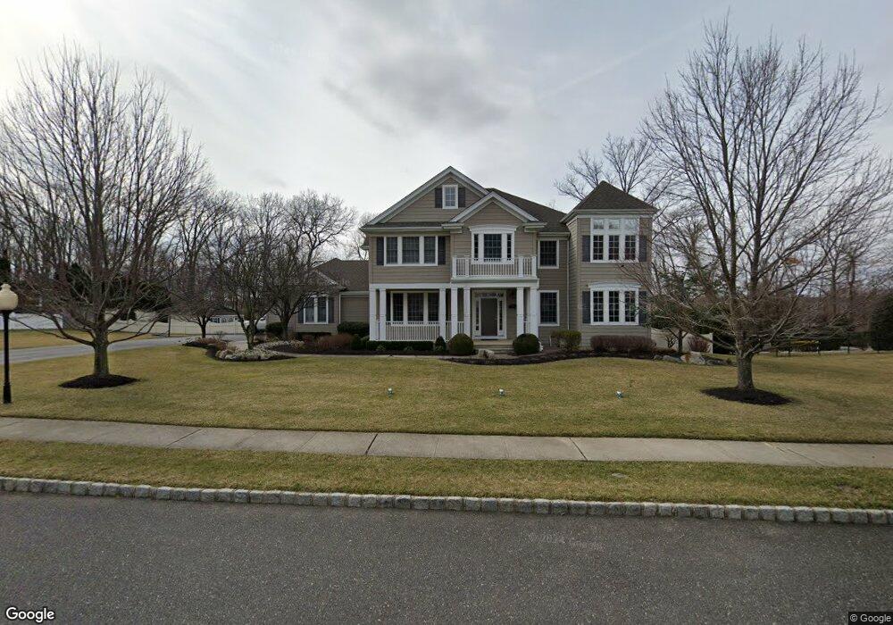
1282 Bradford Run Spring Lake, NJ 07762
Estimated Value: $1,125,000 - $1,678,000
4
Beds
3
Baths
4,093
Sq Ft
$341/Sq Ft
Est. Value
About This Home
This home is located at 1282 Bradford Run, Spring Lake, NJ 07762 and is currently estimated at $1,393,723, approximately $340 per square foot. 1282 Bradford Run is a home located in Monmouth County with nearby schools including Wall High School and The Brookside School.
Ownership History
Date
Name
Owned For
Owner Type
Purchase Details
Closed on
Nov 23, 2005
Sold by
Bradford Run Llc
Bought by
Cheche Peter and Cheche Pamela B
Current Estimated Value
Home Financials for this Owner
Home Financials are based on the most recent Mortgage that was taken out on this home.
Original Mortgage
$350,000
Outstanding Balance
$185,394
Interest Rate
5.5%
Mortgage Type
Adjustable Rate Mortgage/ARM
Estimated Equity
$1,208,329
Create a Home Valuation Report for This Property
The Home Valuation Report is an in-depth analysis detailing your home's value as well as a comparison with similar homes in the area
Home Values in the Area
Average Home Value in this Area
Purchase History
| Date | Buyer | Sale Price | Title Company |
|---|---|---|---|
| Cheche Peter | $849,999 | -- |
Source: Public Records
Mortgage History
| Date | Status | Borrower | Loan Amount |
|---|---|---|---|
| Open | Cheche Peter | $350,000 |
Source: Public Records
Tax History Compared to Growth
Tax History
| Year | Tax Paid | Tax Assessment Tax Assessment Total Assessment is a certain percentage of the fair market value that is determined by local assessors to be the total taxable value of land and additions on the property. | Land | Improvement |
|---|---|---|---|---|
| 2025 | $16,899 | $800,900 | $212,300 | $588,600 |
| 2024 | $16,394 | $800,900 | $212,300 | $588,600 |
| 2023 | $16,394 | $800,900 | $212,300 | $588,600 |
| 2022 | $15,994 | $800,900 | $212,300 | $588,600 |
| 2021 | $15,994 | $800,900 | $212,300 | $588,600 |
| 2020 | $15,802 | $800,900 | $212,300 | $588,600 |
| 2019 | $15,610 | $800,900 | $212,300 | $588,600 |
| 2018 | $15,473 | $800,900 | $212,300 | $588,600 |
| 2017 | $15,169 | $800,900 | $212,300 | $588,600 |
| 2016 | $14,849 | $800,900 | $212,300 | $588,600 |
| 2015 | $16,219 | $549,800 | $138,000 | $411,800 |
| 2014 | $15,940 | $537,600 | $138,000 | $399,600 |
Source: Public Records
Map
Nearby Homes
- 1301 Warren Ave Unit 5
- 2005 Nassau Dr
- 19 Willow Ln
- 2217 Old Mill Rd
- 817 Ocean Rd
- 530 Highway 71 Unit 4
- 805 Jersey Ave
- 24 Old Mill Ct
- 613 Warren Ave
- 601 Central Ave
- 2419 Kipling Ave
- 1442 Garrett Dr
- 905 Wall Rd
- 513 Mercer Ave
- 1838 Highway 35 Unit 36
- 11 Tarpon Dr Unit 1001
- 418 Monmouth Ave
- 418 Salem Ave
- 12 Wyckham Rd
- 15 Wyckham Rd
- 1280 Bradford Run
- 1286 Bradford Run
- 1283 Bradford Run
- 1285 Bradford Run
- 1281 Bradford Run
- 1287 Bradford Run
- 1279 Bradford Run
- 1278 Bradford Run
- 1291 Wedgewood Rd
- 515 Old Mill Rd
- 513 Old Mill Rd
- 511 Old Mill Rd
- 1277 Bradford Run
- 533 Old Mill Rd
- 2038 New Bedford Rd
- 535 Old Mill Rd
- 509 Old Mill Rd
- 2032 New Bedford Rd
- 1293 Wedgewood Rd
- 2024 New Bedford Rd Unit 1A