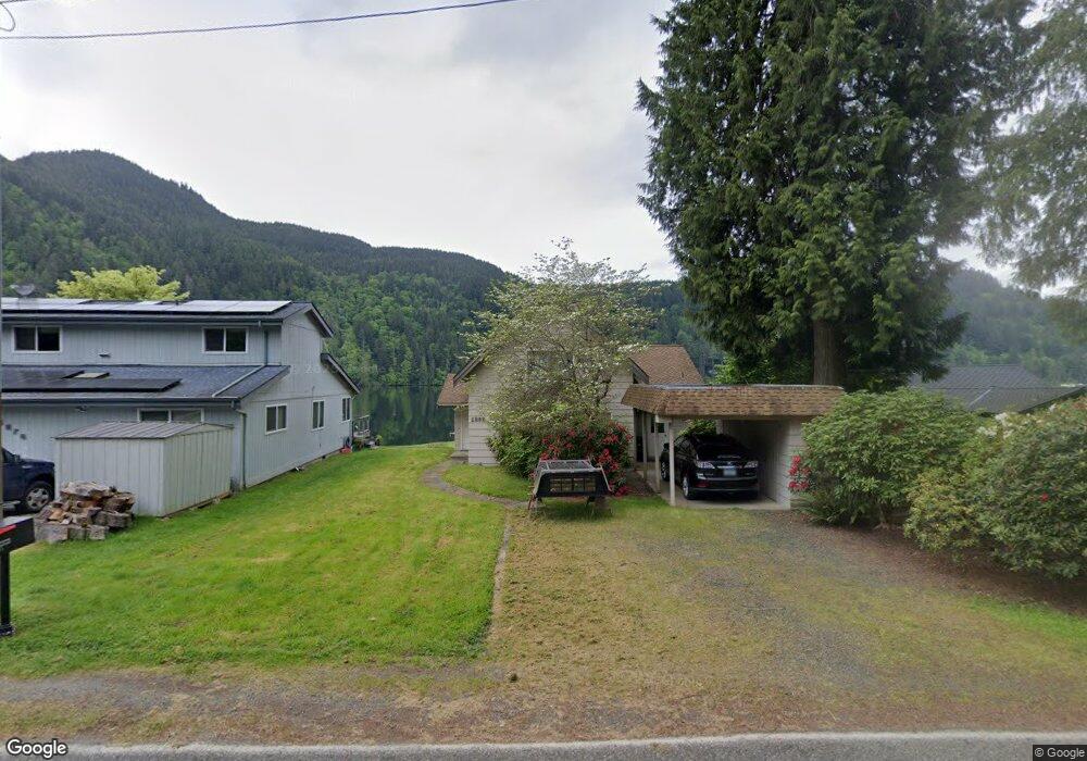
1282 Roy Rd Bellingham, WA 98229
Estimated Value: $942,000 - $1,371,000
2
Beds
2
Baths
1,776
Sq Ft
$699/Sq Ft
Est. Value
About This Home
This home is located at 1282 Roy Rd, Bellingham, WA 98229 and is currently estimated at $1,241,833, approximately $699 per square foot. 1282 Roy Rd is a home located in Whatcom County with nearby schools including Wade King Elementary School, Fairhaven Middle School, and Sehome High School.
Ownership History
Date
Name
Owned For
Owner Type
Purchase Details
Closed on
Dec 6, 2023
Sold by
Meitner Pamela
Bought by
Pamela Meitner Revocable Trust and W Bruce Larson Trust
Current Estimated Value
Purchase Details
Closed on
Jul 29, 2016
Sold by
Yount Carol L
Bought by
Larson W Bruce and Meitner Pamela
Create a Home Valuation Report for This Property
The Home Valuation Report is an in-depth analysis detailing your home's value as well as a comparison with similar homes in the area
Home Values in the Area
Average Home Value in this Area
Purchase History
| Date | Buyer | Sale Price | Title Company |
|---|---|---|---|
| Pamela Meitner Revocable Trust | $313 | None Listed On Document | |
| Pamela Meitner Revocable Trust | $313 | None Listed On Document | |
| Larson W Bruce | $275,000 | Chicago Title Insurance |
Source: Public Records
Tax History Compared to Growth
Tax History
| Year | Tax Paid | Tax Assessment Tax Assessment Total Assessment is a certain percentage of the fair market value that is determined by local assessors to be the total taxable value of land and additions on the property. | Land | Improvement |
|---|---|---|---|---|
| 2024 | $10,309 | $1,185,253 | $857,996 | $327,257 |
| 2023 | $10,309 | $1,227,628 | $888,671 | $338,957 |
| 2022 | $8,889 | $1,044,796 | $756,320 | $288,476 |
| 2021 | $7,924 | $842,600 | $609,952 | $232,648 |
| 2020 | $7,757 | $739,117 | $535,041 | $204,076 |
| 2019 | $7,114 | $701,582 | $507,870 | $193,712 |
| 2018 | $7,412 | $645,582 | $446,846 | $198,736 |
| 2017 | $6,547 | $573,041 | $396,634 | $176,407 |
| 2016 | $5,929 | $527,493 | $364,954 | $162,539 |
| 2015 | $5,822 | $500,164 | $345,946 | $154,218 |
| 2014 | -- | $476,339 | $329,472 | $146,867 |
| 2013 | -- | $455,485 | $316,800 | $138,685 |
Source: Public Records
Map
Nearby Homes
- 961 W Lake Samish Dr
- 715 Samish Heights Ln
- 665 Samish Ln
- 921 Autumn Ln Unit 221
- 921 Autumn Ln Unit 205
- 921 Autumn Ln Unit 243
- 471 Summerland Rd
- 0 Stoney Brook Ln
- 562 W Lake Samish Dr
- 486 W Lake Samish Dr
- 4476 Stoney Brook Ln
- 0 XXXX Stoney Brook Ln Unit E 6-7
- 316 W Lake Samish Dr Unit 35
- 316 W Lake Samish Dr Unit 21
- 316 W Lake Samish Dr
- 125 Summerland Rd
- 550 Manley Rd
- 268 Friday Creek Rd
- 123 Hiline Rd
- 4949 Samish Way Unit 17