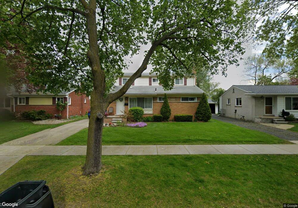
1284 N Selfridge Blvd Clawson, MI 48017
Estimated Value: $363,486 - $381,000
4
Beds
2
Baths
1,500
Sq Ft
$248/Sq Ft
Est. Value
About This Home
This home is located at 1284 N Selfridge Blvd, Clawson, MI 48017 and is currently estimated at $371,622, approximately $247 per square foot. 1284 N Selfridge Blvd is a home located in Oakland County with nearby schools including Clawson High School, Japhet School, and Guardian Angels School.
Ownership History
Date
Name
Owned For
Owner Type
Purchase Details
Closed on
Mar 25, 2005
Sold by
Bohacek Robert J
Bought by
Johnson Valerie L
Current Estimated Value
Home Financials for this Owner
Home Financials are based on the most recent Mortgage that was taken out on this home.
Original Mortgage
$130,000
Outstanding Balance
$64,987
Interest Rate
5.5%
Mortgage Type
Unknown
Estimated Equity
$306,635
Create a Home Valuation Report for This Property
The Home Valuation Report is an in-depth analysis detailing your home's value as well as a comparison with similar homes in the area
Home Values in the Area
Average Home Value in this Area
Purchase History
| Date | Buyer | Sale Price | Title Company |
|---|---|---|---|
| Johnson Valerie L | -- | -- |
Source: Public Records
Mortgage History
| Date | Status | Borrower | Loan Amount |
|---|---|---|---|
| Open | Johnson Valerie L | $130,000 | |
| Closed | Johnson Valerie L | $41,500 |
Source: Public Records
Tax History Compared to Growth
Tax History
| Year | Tax Paid | Tax Assessment Tax Assessment Total Assessment is a certain percentage of the fair market value that is determined by local assessors to be the total taxable value of land and additions on the property. | Land | Improvement |
|---|---|---|---|---|
| 2024 | $3,855 | $158,030 | $0 | $0 |
| 2023 | $3,696 | $145,050 | $0 | $0 |
| 2022 | $3,725 | $134,570 | $0 | $0 |
| 2021 | $3,649 | $127,580 | $0 | $0 |
| 2020 | $3,535 | $120,470 | $0 | $0 |
| 2019 | $3,653 | $116,090 | $0 | $0 |
| 2018 | $3,627 | $107,090 | $0 | $0 |
| 2017 | $3,605 | $104,090 | $0 | $0 |
| 2016 | $3,647 | $98,040 | $0 | $0 |
| 2015 | -- | $89,980 | $0 | $0 |
| 2014 | -- | $77,890 | $0 | $0 |
| 2011 | -- | $70,500 | $0 | $0 |
Source: Public Records
Map
Nearby Homes
- 1226 Shenandoah Dr
- 1092 Shenandoah Dr
- 1341 Oakley Rd
- Fairfax Plan at The Village at Clawson Park
- Penrose Plan at The Village at Clawson Park
- 659 W Maple Rd
- 908 W Elmwood Ave
- 275 Council Ave
- 846 Phillips Ave
- 351 W Baker Ave
- 609 John M Ave
- 71 Cloveridge Dr
- 4909 Coventry St Unit 287
- 1806 Torquay Ave
- 1936 Torquay Ave Unit 205
- 71 Biltmore Dr
- 290 Broadacre Ave
- 1153 Kirts Blvd
- 4921 N Crooks Rd Unit N-10
- 1105 Kirts Blvd Unit A
- 1294 N Selfridge Blvd
- 1274 N Selfridge Blvd
- 1265 Marc Ave
- 1264 N Selfridge Blvd
- 1255 Marc Ave
- 1275 Marc Ave
- 1245 Marc Ave
- 1314 N Selfridge Blvd
- 1285 Marc Ave
- 1254 N Selfridge Blvd
- 1235 Marc Ave
- 1291 N Selfridge Blvd
- 1281 N Selfridge Blvd
- 1301 N Selfridge Blvd
- 1269 N Selfridge Blvd
- 1295 Marc Ave
- 1311 N Selfridge Blvd
- 1225 Marc Ave
- 1324 N Selfridge Blvd
- 1244 N Selfridge Blvd