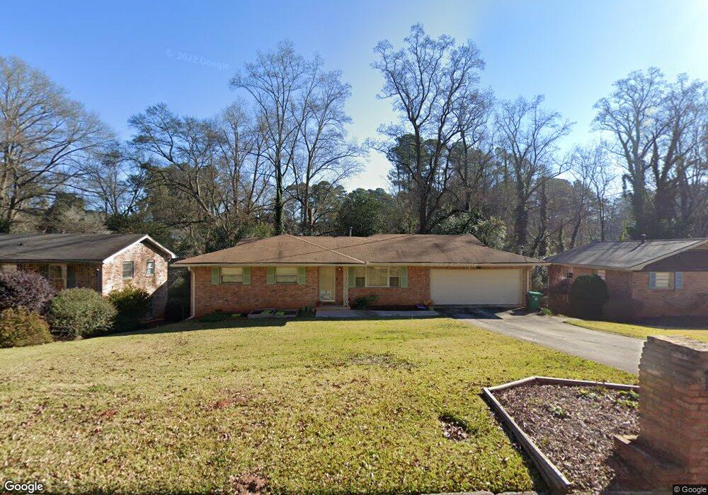
1284 Weston Dr Decatur, GA 30032
Estimated Value: $366,870 - $418,000
3
Beds
2
Baths
2,615
Sq Ft
$153/Sq Ft
Est. Value
About This Home
This home is located at 1284 Weston Dr, Decatur, GA 30032 and is currently estimated at $400,218, approximately $153 per square foot. 1284 Weston Dr is a home located in DeKalb County with nearby schools including Peachcrest Elementary School, Mary McLeod Bethune Middle School, and Towers High School.
Ownership History
Date
Name
Owned For
Owner Type
Purchase Details
Closed on
Mar 17, 2022
Sold by
Solomon Kenneth G
Bought by
Crowell Solomon Kimberly
Current Estimated Value
Home Financials for this Owner
Home Financials are based on the most recent Mortgage that was taken out on this home.
Original Mortgage
$206,660
Outstanding Balance
$193,267
Interest Rate
4.16%
Mortgage Type
New Conventional
Estimated Equity
$206,951
Create a Home Valuation Report for This Property
The Home Valuation Report is an in-depth analysis detailing your home's value as well as a comparison with similar homes in the area
Home Values in the Area
Average Home Value in this Area
Purchase History
| Date | Buyer | Sale Price | Title Company |
|---|---|---|---|
| Crowell Solomon Kimberly | -- | -- |
Source: Public Records
Mortgage History
| Date | Status | Borrower | Loan Amount |
|---|---|---|---|
| Open | Crowell Solomon Kimberly | $206,660 |
Source: Public Records
Tax History Compared to Growth
Tax History
| Year | Tax Paid | Tax Assessment Tax Assessment Total Assessment is a certain percentage of the fair market value that is determined by local assessors to be the total taxable value of land and additions on the property. | Land | Improvement |
|---|---|---|---|---|
| 2025 | $4,678 | $158,120 | $38,240 | $119,880 |
| 2024 | $4,994 | $165,000 | $38,240 | $126,760 |
| 2023 | $4,994 | $144,000 | $35,000 | $109,000 |
| 2022 | $3,096 | $104,200 | $16,000 | $88,200 |
| 2021 | $2,816 | $92,080 | $16,000 | $76,080 |
| 2020 | $2,263 | $67,920 | $16,000 | $51,920 |
| 2019 | $2,615 | $84,120 | $16,000 | $68,120 |
| 2018 | $1,358 | $50,840 | $6,120 | $44,720 |
| 2017 | $1,660 | $47,760 | $6,120 | $41,640 |
| 2016 | $1,418 | $41,880 | $6,120 | $35,760 |
| 2014 | $1,261 | $33,400 | $6,120 | $27,280 |
Source: Public Records
Map
Nearby Homes
- 1309 Weston Dr
- 1244 Weston Dr Unit 1
- 1401 Richard Rd
- 1407 Richard Rd
- 1350 Weston Dr
- 3581 Turner Heights Dr
- 3571 Turner Heights Dr
- 3558 Turner Heights Dr
- 1376 Cornwall Rd
- 1255 Glen Forest Way
- 3465 Glen Rd
- 3589 Orchard Cir
- 3601 Orchard Cir
- 4250 Timber Valley Ct
- 1146 Canal St
- 3820 Covington Hwy
- 4242 Timber Valley Ct
- 1145 Canal St
- 3444 Orchard Cir
- 1425 Cobb Branch Dr
- 1278 Weston Dr
- 1292 Weston Dr
- 1298 Weston Dr
- 1271 Cornwall Rd
- 1270 Weston Dr Unit I
- 1285 Weston Dr
- 1279 Weston Dr
- 1253 Cornwall Rd
- 1293 Weston Dr
- 1306 Weston Dr
- 1277 Cornwall Rd
- 1285 Cornwall Rd
- 3594 Farnham Ct Unit 2
- 1271 Weston Dr
- 1301 Weston Dr Unit 1
- 1422 Weston Dr
- 1265 Weston Dr
- 1312 Weston Dr
- 1291 Cornwall Rd
- 3602 Farnham Ct