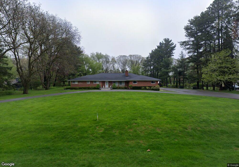
1285 Robson Ln Bloomfield Hills, MI 48304
Estimated Value: $729,701 - $923,000
5
Beds
4
Baths
2,893
Sq Ft
$278/Sq Ft
Est. Value
About This Home
This home is located at 1285 Robson Ln, Bloomfield Hills, MI 48304 and is currently estimated at $803,675, approximately $277 per square foot. 1285 Robson Ln is a home located in Oakland County with nearby schools including Eastover Elementary School, Bloomfield Hills High School, and Academy of Sacred Heart.
Ownership History
Date
Name
Owned For
Owner Type
Purchase Details
Closed on
Mar 27, 2015
Sold by
Dawes Dennis E and Dawes Shawn M
Bought by
Abro Raymond
Current Estimated Value
Purchase Details
Closed on
Jul 17, 1995
Sold by
Reed Melvin L
Bought by
Dawes Dennis E and Dawes Shawn M
Home Financials for this Owner
Home Financials are based on the most recent Mortgage that was taken out on this home.
Original Mortgage
$185,000
Interest Rate
7.59%
Mortgage Type
New Conventional
Create a Home Valuation Report for This Property
The Home Valuation Report is an in-depth analysis detailing your home's value as well as a comparison with similar homes in the area
Home Values in the Area
Average Home Value in this Area
Purchase History
| Date | Buyer | Sale Price | Title Company |
|---|---|---|---|
| Abro Raymond | $430,000 | Century Title Agency Sevcs | |
| Dawes Dennis E | $253,000 | -- |
Source: Public Records
Mortgage History
| Date | Status | Borrower | Loan Amount |
|---|---|---|---|
| Previous Owner | Dawes Dennis E | $185,000 |
Source: Public Records
Tax History Compared to Growth
Tax History
| Year | Tax Paid | Tax Assessment Tax Assessment Total Assessment is a certain percentage of the fair market value that is determined by local assessors to be the total taxable value of land and additions on the property. | Land | Improvement |
|---|---|---|---|---|
| 2024 | $4,739 | $307,370 | $0 | $0 |
| 2023 | $4,587 | $265,250 | $0 | $0 |
| 2022 | $9,762 | $269,120 | $0 | $0 |
| 2021 | $9,734 | $267,630 | $0 | $0 |
| 2020 | $4,195 | $249,140 | $0 | $0 |
| 2019 | $9,291 | $216,410 | $0 | $0 |
| 2018 | $9,498 | $214,950 | $0 | $0 |
| 2017 | $9,643 | $214,960 | $0 | $0 |
| 2016 | $9,873 | $217,710 | $0 | $0 |
| 2015 | -- | $202,150 | $0 | $0 |
| 2014 | -- | $166,510 | $0 | $0 |
| 2011 | -- | $154,730 | $0 | $0 |
Source: Public Records
Map
Nearby Homes
- 2953 Squire Ct
- 4.8 Acres Westview Rd
- 952 Dursley Rd
- 1136 Meadowglen Ct Unit S80
- 1105 Ivyglen Cir
- 2928 Vineyards Dr
- 1204 S Timberview Trail Unit E 23
- 1289 Greenglen Ct
- 1285 Greenglen Ct
- 1339 Knollcrest Cir
- 1470 Timberview Trail
- 790 Hidden Pine Rd
- 3370 BlooMcRest Dr
- 2156 Park Ridge Dr
- 2576 Homewood Dr
- 1926 Hickory Bark Ln
- 3340 Kernway Dr
- 1916 Squirrel Valley Dr
- 909 Tartan Trail Unit 203
- 2409 Wildbrook Run Unit 182