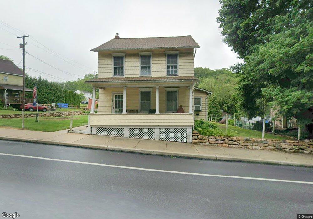
1286 Main St Slatington, PA 18080
Estimated Value: $262,000 - $319,000
4
Beds
1
Bath
2,244
Sq Ft
$128/Sq Ft
Est. Value
About This Home
This home is located at 1286 Main St, Slatington, PA 18080 and is currently estimated at $288,314, approximately $128 per square foot. 1286 Main St is a home located in Lehigh County with nearby schools including Deep Creek Central Elementary School, Grassfield Elementary School, and Peters Elementary School.
Ownership History
Date
Name
Owned For
Owner Type
Purchase Details
Closed on
Sep 17, 2004
Sold by
Delong Jeffrey C and Delong Cherie Ilene
Bought by
Delong Jeffrey C
Current Estimated Value
Purchase Details
Closed on
Sep 1, 1995
Sold by
Delong Jeffrey
Bought by
Delong Jeffrey and Cherie Ileene
Purchase Details
Closed on
Jun 21, 1990
Sold by
Delong Jeffrey C and Delong Julia C
Bought by
Delong Jeffrey C
Purchase Details
Closed on
Dec 30, 1986
Sold by
Kraft Melvyn W and Kraft Charlotte
Bought by
Delong Jeffrey C and Delong Julia C
Purchase Details
Closed on
Dec 6, 1985
Bought by
Kraft Melvyn W and Kraft Charlotte
Create a Home Valuation Report for This Property
The Home Valuation Report is an in-depth analysis detailing your home's value as well as a comparison with similar homes in the area
Home Values in the Area
Average Home Value in this Area
Purchase History
| Date | Buyer | Sale Price | Title Company |
|---|---|---|---|
| Delong Jeffrey C | -- | -- | |
| Delong Jeffrey | -- | -- | |
| Delong Jeffrey C | -- | -- | |
| Delong Jeffrey C | $44,000 | -- | |
| Kraft Melvyn W | $33,000 | -- |
Source: Public Records
Tax History Compared to Growth
Tax History
| Year | Tax Paid | Tax Assessment Tax Assessment Total Assessment is a certain percentage of the fair market value that is determined by local assessors to be the total taxable value of land and additions on the property. | Land | Improvement |
|---|---|---|---|---|
| 2025 | $5,214 | $138,100 | $34,400 | $103,700 |
| 2024 | $4,992 | $138,100 | $34,400 | $103,700 |
| 2023 | $4,702 | $138,100 | $34,400 | $103,700 |
| 2022 | $4,632 | $138,100 | $103,700 | $34,400 |
| 2021 | $4,492 | $138,100 | $34,400 | $103,700 |
| 2020 | $4,363 | $138,100 | $34,400 | $103,700 |
| 2019 | $4,267 | $138,100 | $34,400 | $103,700 |
| 2018 | $4,182 | $138,100 | $34,400 | $103,700 |
| 2017 | $4,165 | $138,100 | $34,400 | $103,700 |
| 2016 | -- | $138,100 | $34,400 | $103,700 |
| 2015 | -- | $138,100 | $34,400 | $103,700 |
| 2014 | -- | $138,100 | $34,400 | $103,700 |
Source: Public Records
Map
Nearby Homes