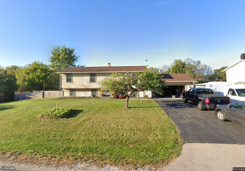
12864 W Maplewood Rd Beach Park, IL 60099
Estimated Value: $287,000 - $337,000
3
Beds
2
Baths
1,064
Sq Ft
$296/Sq Ft
Est. Value
About This Home
This home is located at 12864 W Maplewood Rd, Beach Park, IL 60099 and is currently estimated at $314,866, approximately $295 per square foot. 12864 W Maplewood Rd is a home located in Lake County with nearby schools including Kenneth Murphy School, Beach Park Middle School, and Zion-Benton Township High School.
Ownership History
Date
Name
Owned For
Owner Type
Purchase Details
Closed on
Jul 31, 2002
Sold by
Splitt Connie N
Bought by
Splitt Thomas M
Current Estimated Value
Purchase Details
Closed on
Sep 29, 1997
Sold by
Ahola Vesa T and Ahola Cindy A
Bought by
Splitt Thomas M and Splitt Connie N
Home Financials for this Owner
Home Financials are based on the most recent Mortgage that was taken out on this home.
Original Mortgage
$130,600
Outstanding Balance
$21,351
Interest Rate
7.65%
Estimated Equity
$293,515
Create a Home Valuation Report for This Property
The Home Valuation Report is an in-depth analysis detailing your home's value as well as a comparison with similar homes in the area
Home Values in the Area
Average Home Value in this Area
Purchase History
| Date | Buyer | Sale Price | Title Company |
|---|---|---|---|
| Splitt Thomas M | -- | -- | |
| Splitt Thomas M | $91,666 | -- |
Source: Public Records
Mortgage History
| Date | Status | Borrower | Loan Amount |
|---|---|---|---|
| Open | Splitt Thomas M | $130,600 |
Source: Public Records
Tax History Compared to Growth
Tax History
| Year | Tax Paid | Tax Assessment Tax Assessment Total Assessment is a certain percentage of the fair market value that is determined by local assessors to be the total taxable value of land and additions on the property. | Land | Improvement |
|---|---|---|---|---|
| 2024 | $6,333 | $83,907 | $10,393 | $73,514 |
| 2023 | $6,424 | $68,296 | $10,033 | $58,263 |
| 2022 | $6,424 | $66,308 | $9,785 | $56,523 |
| 2021 | $6,625 | $64,621 | $9,536 | $55,085 |
| 2020 | $6,490 | $61,667 | $9,100 | $52,567 |
| 2019 | $6,464 | $58,508 | $8,634 | $49,874 |
| 2018 | $6,825 | $59,471 | $10,465 | $49,006 |
| 2017 | $6,767 | $55,947 | $9,845 | $46,102 |
| 2016 | $6,584 | $53,263 | $9,373 | $43,890 |
| 2015 | $6,377 | $48,847 | $8,596 | $40,251 |
| 2014 | $5,266 | $44,047 | $2,939 | $41,108 |
| 2012 | $5,324 | $45,772 | $3,054 | $42,718 |
Source: Public Records
Map
Nearby Homes
- 13051 Bucksburn Ct
- 39787 Torry Ln
- 39520 N Green Bay Rd
- 13129 W Shannon Dr
- 13154 W Sheffield Ln
- 39631 N Warren Ln Unit 4625
- 39616 N Warren Ln Unit 4824
- 39401 N Green Bay Rd
- 13661 W Adams Rd
- 13551 W Adams Rd
- 13428 Victoria Ln
- 2414 Phillip Dr
- 2407 Phillip Dr
- 2407 Miriam Ave
- 42334 N Heritage Lot 7 Trail
- 2413 Michael Ave
- 39113 N Green Bay Rd
- 39176 Welsh Ln Unit 5563
- 39092 Welsh Ln Unit 5501
- 39111 N Aberdeen Ln Unit 39111
- 12834 W Maplewood Rd
- 12854 W Maplewood Rd
- 12853 W 29th St
- 12824 W Maplewood Rd
- 12871 W Maplewood Rd
- 12845 W Maplewood Rd
- 12825 W 29th St
- 12850 W 29th St
- 12798 W Maplewood Rd
- 12795 W 29th St
- 12880 W 29th St
- 12860 W Clarendon Rd
- 39890 N Green Ave
- 12668 W Maplewood Rd
- 12936 W Maplewood Rd
- 12778 W Maplewood Rd
- 40045 N Green Ave
- 12963 W 29th St
- 12771 W 29th St
- 12949 W Maplewood Rd