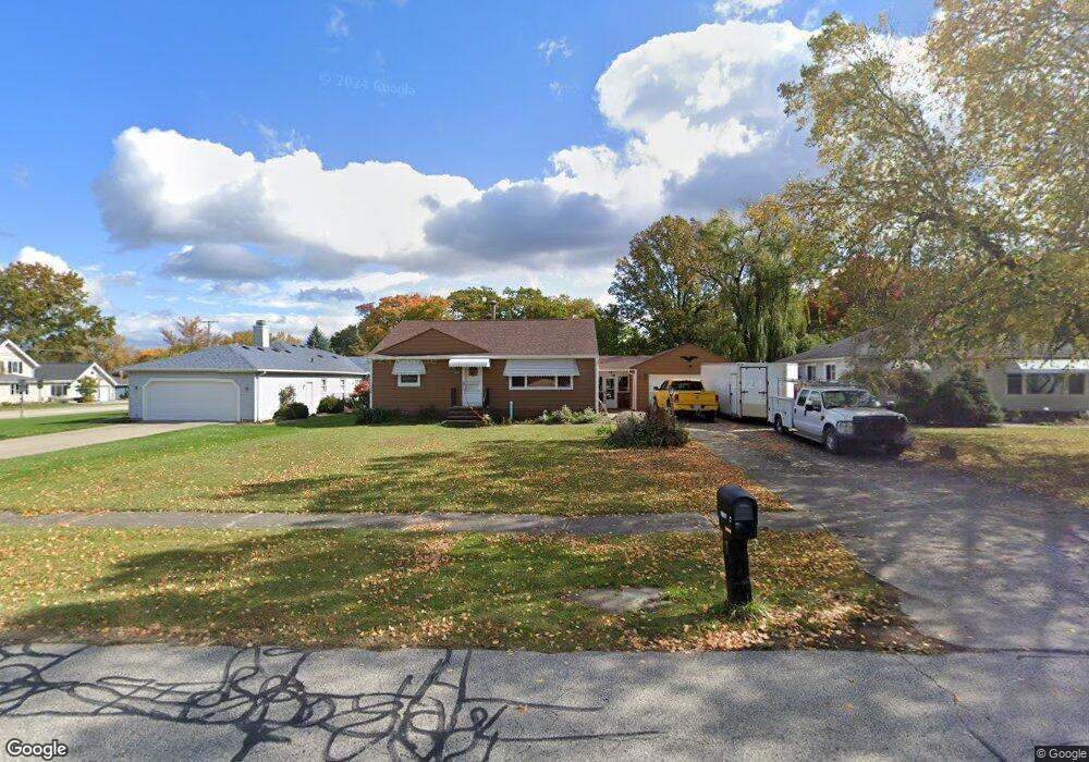
12877 Atlantic Rd Strongsville, OH 44149
Estimated Value: $219,000 - $267,000
3
Beds
1
Bath
1,292
Sq Ft
$191/Sq Ft
Est. Value
About This Home
This home is located at 12877 Atlantic Rd, Strongsville, OH 44149 and is currently estimated at $246,246, approximately $190 per square foot. 12877 Atlantic Rd is a home located in Cuyahoga County with nearby schools including Strongsville High School, Sts Joseph & John Interparochial School, and Royal Redeemer Lutheran School.
Ownership History
Date
Name
Owned For
Owner Type
Purchase Details
Closed on
May 1, 2017
Sold by
Zimmer Walter J
Bought by
Zimmer Ashleigh Brooke
Current Estimated Value
Purchase Details
Closed on
Feb 13, 2017
Sold by
Roth James W
Bought by
Zimmer Walter J
Purchase Details
Closed on
Mar 13, 2007
Sold by
Connell Roth Marcia and Roth James W
Bought by
Roth James W and Connell Roth Marcia
Purchase Details
Closed on
Jun 6, 1978
Sold by
Mattison David O
Bought by
Connell Marcia
Purchase Details
Closed on
May 18, 1977
Sold by
Brown Russell B and Brown Lois M
Bought by
Mattison David O
Purchase Details
Closed on
Jan 1, 1975
Bought by
Brown Russell B and Brown Lois M
Create a Home Valuation Report for This Property
The Home Valuation Report is an in-depth analysis detailing your home's value as well as a comparison with similar homes in the area
Home Values in the Area
Average Home Value in this Area
Purchase History
| Date | Buyer | Sale Price | Title Company |
|---|---|---|---|
| Zimmer Ashleigh Brooke | -- | None Available | |
| Zimmer Walter J | $80,000 | None Available | |
| Roth James W | -- | None Available | |
| Connell Marcia | $58,000 | -- | |
| Mattison David O | $50,500 | -- | |
| Brown Russell B | -- | -- |
Source: Public Records
Tax History Compared to Growth
Tax History
| Year | Tax Paid | Tax Assessment Tax Assessment Total Assessment is a certain percentage of the fair market value that is determined by local assessors to be the total taxable value of land and additions on the property. | Land | Improvement |
|---|---|---|---|---|
| 2024 | $3,456 | $73,605 | $13,755 | $59,850 |
| 2023 | $3,456 | $55,200 | $14,320 | $40,880 |
| 2022 | $3,431 | $55,200 | $14,320 | $40,880 |
| 2021 | $3,404 | $55,200 | $14,320 | $40,880 |
| 2020 | $3,153 | $45,220 | $11,730 | $33,500 |
| 2019 | $3,060 | $129,200 | $33,500 | $95,700 |
| 2018 | $2,741 | $45,220 | $11,730 | $33,500 |
| 2017 | $2,753 | $40,460 | $10,010 | $30,450 |
| 2016 | $2,731 | $40,460 | $10,010 | $30,450 |
| 2015 | $2,689 | $40,460 | $10,010 | $30,450 |
| 2014 | $2,689 | $39,270 | $9,730 | $29,540 |
Source: Public Records
Map
Nearby Homes
- 12651 Alameda Dr
- 13236 Tomson Dr
- 20469 Westwood Park Blvd
- 12647 Edgepark Cir
- 12694 Ionia Ct
- 22125 Olde Creek Trail
- 21469 Woodview Cir
- 12385 Corinth Ct
- 22235 North Trail
- 12539 Olympus Way
- 14400 Prospect Rd
- 13066 Olympus Way
- 13156 Olympus Way
- 13099 Olympus Way
- 20078 Trapper Trail
- 14112 Settlers Way
- 21359 Briar Bush Ln
- 19620 Porters Ln Unit 15F
- 14896 Britannia Ct
- 14890 Prospect Rd
- 12921 Atlantic Rd
- 12833 Atlantic Rd
- 12963 Atlantic Rd
- 20589 Westwood Dr
- 20662 Westwood Dr
- 20622 Westwood Dr
- 13007 Atlantic Rd
- 20557 Westwood Dr
- 12876 Atlantic Rd
- 12828 Atlantic Rd
- 12920 Atlantic Rd
- 12966 Atlantic Rd
- 13015 Atlantic Rd
- 20527 Westwood Dr
- 20564 Westwood Dr
- 13006 Atlantic Rd
- 20556 Westwood Dr
- 13101 Atlantic Rd
- 20501 Westwood Dr
- 13052 Atlantic Rd