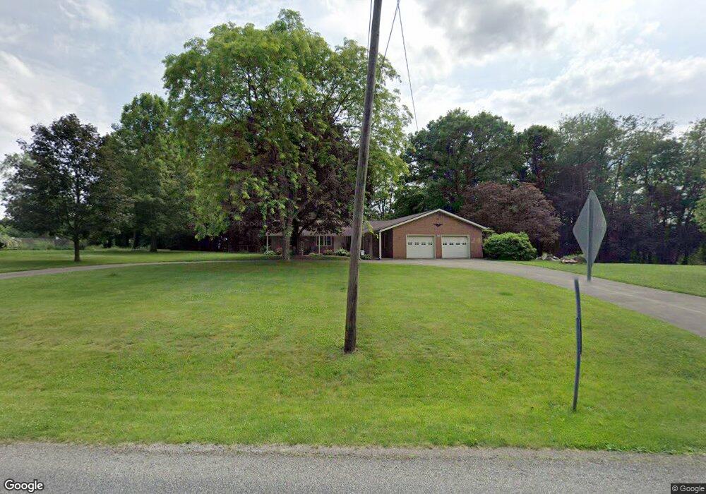
12894 Clinton Rd Doylestown, OH 44230
Estimated Value: $306,247 - $339,000
2
Beds
2
Baths
1,856
Sq Ft
$172/Sq Ft
Est. Value
About This Home
This home is located at 12894 Clinton Rd, Doylestown, OH 44230 and is currently estimated at $320,062, approximately $172 per square foot. 12894 Clinton Rd is a home located in Wayne County with nearby schools including Hazel Harvey Elementary School, Chippewa Intermediate School, and Chippewa Jr./Sr. High School.
Ownership History
Date
Name
Owned For
Owner Type
Purchase Details
Closed on
Aug 12, 2016
Sold by
Perrine Herbert M
Bought by
Carol A Perrine
Current Estimated Value
Purchase Details
Closed on
Dec 28, 1987
Sold by
Hickerson John S and Hickerson Mary L
Bought by
Perrine Herbert M and Perrine Carol
Create a Home Valuation Report for This Property
The Home Valuation Report is an in-depth analysis detailing your home's value as well as a comparison with similar homes in the area
Home Values in the Area
Average Home Value in this Area
Purchase History
| Date | Buyer | Sale Price | Title Company |
|---|---|---|---|
| Carol A Perrine | -- | -- | |
| Perrine Herbert M | $69,900 | -- |
Source: Public Records
Tax History
| Year | Tax Paid | Tax Assessment Tax Assessment Total Assessment is a certain percentage of the fair market value that is determined by local assessors to be the total taxable value of land and additions on the property. | Land | Improvement |
|---|---|---|---|---|
| 2024 | $2,799 | $89,510 | $19,390 | $70,120 |
| 2023 | $2,769 | $89,510 | $19,390 | $70,120 |
| 2022 | $1,986 | $61,300 | $13,280 | $48,020 |
| 2021 | $2,000 | $61,300 | $13,280 | $48,020 |
| 2020 | $2,014 | $61,300 | $13,280 | $48,020 |
| 2019 | $1,571 | $48,250 | $12,890 | $35,360 |
| 2018 | $1,587 | $48,250 | $12,890 | $35,360 |
| 2017 | $1,543 | $48,250 | $12,890 | $35,360 |
| 2016 | $1,520 | $46,390 | $12,390 | $34,000 |
| 2015 | $1,513 | $46,390 | $12,390 | $34,000 |
| 2014 | $1,329 | $46,390 | $12,390 | $34,000 |
| 2013 | $1,363 | $46,180 | $11,760 | $34,420 |
Source: Public Records
Map
Nearby Homes
- 100 Merlot Ct
- 46 Hidden Pond Dr
- 325 Catawba Path
- 12214 Vince Dr
- TBD Coal Bank Rd
- 12045 Coal Bank Rd
- 15899 Mccallum Dr
- 288 E Clinton St
- 0 S Portage St
- 580 Thorn Way
- 680 Thorn Way
- 620 Thorn Way
- 93 Cleveland Ave
- 436 N Portage St
- 18592 Edwards Rd Unit 169
- 18592 Edwards Rd Unit 100
- 18592 Edwards Rd Unit 137
- 18592 Edwards Rd Unit 243
- 18592 Edwards Rd Unit 3
- 18592 Edwards Rd
- 12864 Clinton Rd
- 12592 Black Diamond Rd
- 12944 Clinton Rd
- 12899 Clinton Rd
- 0 Black Diamond Rd
- 12943 Clinton Rd
- 12952 Clinton Rd
- 12621 Black Diamond Rd
- 12518 Black Diamond Rd
- 12500 Black Diamond Rd
- 12802 Clinton St
- 12802 Clinton Rd
- 12555 Black Diamond Rd
- 12972 Clinton Rd
- 12708 Calaboone Rd
- 12446 Black Diamond Rd
- 12764 Clinton Rd
- 12763 Clinton Rd
- 13023 Clinton Rd
- 12749 Clinton Rd
Your Personal Tour Guide
Ask me questions while you tour the home.