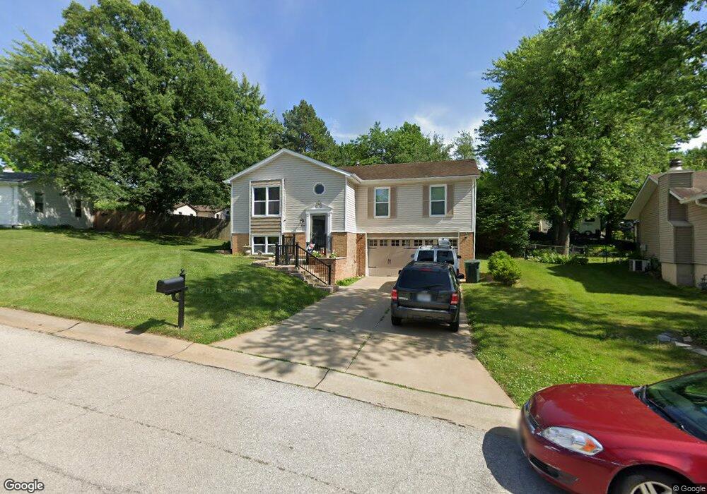
129 Burning Leaf Dr Saint Peters, MO 63376
Estimated Value: $304,000 - $313,000
3
Beds
2
Baths
1,273
Sq Ft
$242/Sq Ft
Est. Value
About This Home
This home is located at 129 Burning Leaf Dr, Saint Peters, MO 63376 and is currently estimated at $307,482, approximately $241 per square foot. 129 Burning Leaf Dr is a home located in St. Charles County with nearby schools including Fairmount Elementary School, Hollenbeck Middle School, and Francis Howell North High School.
Ownership History
Date
Name
Owned For
Owner Type
Purchase Details
Closed on
Dec 19, 2017
Sold by
Walters Clarence A and Walters Heather S
Bought by
Heather S Walters Revocable Trust
Current Estimated Value
Purchase Details
Closed on
Aug 3, 2007
Sold by
Us Bank Na
Bought by
Walters Clarence A and Walters Heather S
Home Financials for this Owner
Home Financials are based on the most recent Mortgage that was taken out on this home.
Original Mortgage
$126,000
Interest Rate
6.66%
Mortgage Type
Purchase Money Mortgage
Purchase Details
Closed on
May 4, 2007
Sold by
Jacobs Beverly M and American Lending Group Inc
Bought by
Us Bank Na and Cmlti 2006-Wfhe3
Create a Home Valuation Report for This Property
The Home Valuation Report is an in-depth analysis detailing your home's value as well as a comparison with similar homes in the area
Home Values in the Area
Average Home Value in this Area
Purchase History
| Date | Buyer | Sale Price | Title Company |
|---|---|---|---|
| Heather S Walters Revocable Trust | -- | None Available | |
| Walters Clarence A | $140,000 | Continental Title Company | |
| Us Bank Na | $156,659 | None Available |
Source: Public Records
Mortgage History
| Date | Status | Borrower | Loan Amount |
|---|---|---|---|
| Previous Owner | Walters Clarence A | $126,000 |
Source: Public Records
Tax History Compared to Growth
Tax History
| Year | Tax Paid | Tax Assessment Tax Assessment Total Assessment is a certain percentage of the fair market value that is determined by local assessors to be the total taxable value of land and additions on the property. | Land | Improvement |
|---|---|---|---|---|
| 2025 | $3,282 | $51,760 | -- | -- |
| 2023 | $3,278 | $46,908 | $0 | $0 |
| 2022 | $2,930 | $39,109 | $0 | $0 |
| 2021 | $2,925 | $39,109 | $0 | $0 |
| 2020 | $2,689 | $35,101 | $0 | $0 |
| 2019 | $2,680 | $35,101 | $0 | $0 |
| 2018 | $2,348 | $29,433 | $0 | $0 |
| 2017 | $2,337 | $29,433 | $0 | $0 |
| 2016 | $2,160 | $27,250 | $0 | $0 |
| 2015 | $2,156 | $27,250 | $0 | $0 |
| 2014 | $2,094 | $25,720 | $0 | $0 |
Source: Public Records
Map
Nearby Homes
- 131 Spring Leaf Dr
- 3 Red Mill Ct
- 416 Horstmeier Trail
- 400 Horstmeier Trail
- 8 Cedarwood Ct
- 201 Driftwood Ln
- 1 Waterbury Ct
- 215 Birchleaf Dr
- 34 Sugar Grove Ct
- 3 Raintree Dr
- 132 Mill Spring Ln
- 12 Mill Brooke Dr
- 205 Barkwood Trails Dr
- 3129 Mcclay Rd
- 826 Sugar Valley Ct
- 1008 Autumn Leaf Dr
- 812 Sugar Valley Ct Unit 5
- 808 Sugar Valley Ct Unit 6
- 813 Sugar Valley Ct Unit 8
- 210 Sugar Lake Dr Unit 6
- 125 Burning Leaf Dr
- 1 Spring Leaf Ct
- 11 Greenhurst Ct
- 201 Briarhill Ct
- 121 Burning Leaf Dr
- 12 Greenhurst Ct
- 10 Greenhurst Ct
- 10 Briarhill Ct
- 122 Burning Leaf Dr
- 849 Greenridge Ln
- 13 Greenhurst Ct
- 117 Burning Leaf Dr
- 118 Burning Leaf Dr
- 9 Briarhill Ct
- 845 Green Ridge Ln
- 845 Greenridge Ln
- 14 Greenhurst Ct
- 140 Burning Leaf Dr
- 113 Burning Leaf Dr
- 114 Burning Leaf Dr