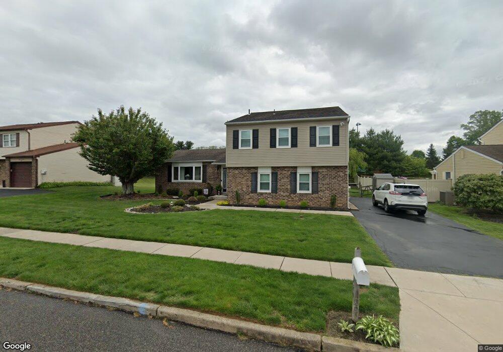
129 Butterworth Ln Langhorne, PA 19047
Estimated Value: $538,000 - $610,000
4
Beds
3
Baths
1,831
Sq Ft
$312/Sq Ft
Est. Value
About This Home
This home is located at 129 Butterworth Ln, Langhorne, PA 19047 and is currently estimated at $571,693, approximately $312 per square foot. 129 Butterworth Ln is a home located in Bucks County with nearby schools including Tawanka Elementary School, Maple Point Middle School, and Neshaminy High School.
Ownership History
Date
Name
Owned For
Owner Type
Purchase Details
Closed on
Apr 26, 1994
Sold by
Katz Roy and Katz Leslie
Bought by
Coates John J and Coates Ellen T
Current Estimated Value
Home Financials for this Owner
Home Financials are based on the most recent Mortgage that was taken out on this home.
Original Mortgage
$110,000
Interest Rate
7.7%
Purchase Details
Closed on
Oct 1, 1979
Bought by
Katz Roy B and Katz Leslie
Create a Home Valuation Report for This Property
The Home Valuation Report is an in-depth analysis detailing your home's value as well as a comparison with similar homes in the area
Home Values in the Area
Average Home Value in this Area
Purchase History
| Date | Buyer | Sale Price | Title Company |
|---|---|---|---|
| Coates John J | $162,000 | First American Title Ins Co | |
| Katz Roy B | $69,000 | -- |
Source: Public Records
Mortgage History
| Date | Status | Borrower | Loan Amount |
|---|---|---|---|
| Closed | Coates John J | $110,000 |
Source: Public Records
Tax History Compared to Growth
Tax History
| Year | Tax Paid | Tax Assessment Tax Assessment Total Assessment is a certain percentage of the fair market value that is determined by local assessors to be the total taxable value of land and additions on the property. | Land | Improvement |
|---|---|---|---|---|
| 2025 | $7,062 | $32,440 | $5,080 | $27,360 |
| 2024 | $7,062 | $32,440 | $5,080 | $27,360 |
| 2023 | $6,950 | $32,440 | $5,080 | $27,360 |
| 2022 | $6,768 | $32,440 | $5,080 | $27,360 |
| 2021 | $6,768 | $32,440 | $5,080 | $27,360 |
| 2020 | $6,687 | $32,440 | $5,080 | $27,360 |
| 2019 | $6,537 | $32,440 | $5,080 | $27,360 |
| 2018 | $6,417 | $32,440 | $5,080 | $27,360 |
| 2017 | $6,253 | $32,440 | $5,080 | $27,360 |
| 2016 | $6,384 | $32,440 | $5,080 | $27,360 |
| 2015 | $6,443 | $32,440 | $5,080 | $27,360 |
| 2014 | $6,443 | $32,440 | $5,080 | $27,360 |
Source: Public Records
Map
Nearby Homes
- 1210 Brownsville Rd
- 166 N Hawthorne Ave
- 1021 W Maple Ave
- 13 Golf Club Dr
- 449 Grand Ave
- 225 Playwicki St
- 565 Hulmeville Rd
- 230 Playwicki St
- 308 W Richardson Ave
- 710 Fox Ct
- 257 Wisteria Ave
- 1605 Old Lincoln Hwy
- 523 Turtle Ln
- 1420 Super Hwy
- 2816 Avenue E
- 2823 Avenue E
- 1516 Fairview Ave
- 0 Prospect Ave
- 1632 Winter Ave
- 731 Highland Ave
- 117 Butterworth Ln
- 139 Butterworth Ln
- 149 Butterworth Ln
- 105 Butterworth Ln
- 128 Butterworth Ln
- 138 Butterworth Ln
- 102 Butterworth Ln
- 148 Butterworth Ln
- 159 Butterworth Ln
- 110 Colonial Dr
- 158 Butterworth Ln
- 1005 Brownsville Rd
- 125 Colonial Dr
- 171 Butterworth Ln
- 145 Colonial Dr
- 176 Butterworth Ln
- 1017 Brownsville Rd
- 155 Colonial Dr
- 118 Colonial Dr
- 962 Broadview Ave