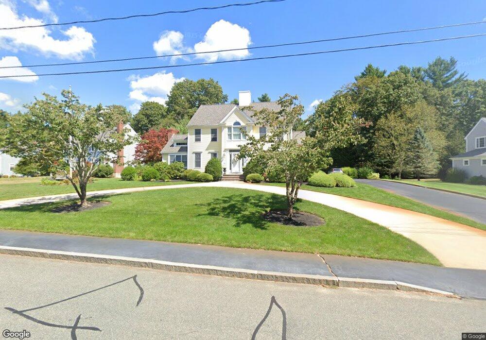
129 Cushing Hill Rd Hanover, MA 02339
Estimated Value: $1,139,923 - $1,269,000
4
Beds
3
Baths
3,000
Sq Ft
$407/Sq Ft
Est. Value
About This Home
This home is located at 129 Cushing Hill Rd, Hanover, MA 02339 and is currently estimated at $1,221,481, approximately $407 per square foot. 129 Cushing Hill Rd is a home located in Plymouth County with nearby schools including Hanover High School, South Shore Charter Public School, and Norwell KinderCare.
Ownership History
Date
Name
Owned For
Owner Type
Purchase Details
Closed on
Sep 28, 2006
Sold by
Lamparelli James V
Bought by
Walker Kenneth A and Walker Patricia A
Current Estimated Value
Home Financials for this Owner
Home Financials are based on the most recent Mortgage that was taken out on this home.
Original Mortgage
$164,000
Interest Rate
6.52%
Create a Home Valuation Report for This Property
The Home Valuation Report is an in-depth analysis detailing your home's value as well as a comparison with similar homes in the area
Home Values in the Area
Average Home Value in this Area
Purchase History
| Date | Buyer | Sale Price | Title Company |
|---|---|---|---|
| Walker Kenneth A | $830,000 | -- | |
| Walker Kenneth A | $830,000 | -- |
Source: Public Records
Mortgage History
| Date | Status | Borrower | Loan Amount |
|---|---|---|---|
| Open | Walker Kenneth A | $409,500 | |
| Closed | Walker Kenneth A | $164,000 |
Source: Public Records
Tax History
| Year | Tax Paid | Tax Assessment Tax Assessment Total Assessment is a certain percentage of the fair market value that is determined by local assessors to be the total taxable value of land and additions on the property. | Land | Improvement |
|---|---|---|---|---|
| 2025 | $12,502 | $1,012,300 | $338,100 | $674,200 |
| 2024 | $12,150 | $946,300 | $338,100 | $608,200 |
| 2023 | $11,793 | $874,200 | $307,300 | $566,900 |
| 2022 | $11,756 | $770,900 | $270,400 | $500,500 |
| 2021 | $11,715 | $717,400 | $245,800 | $471,600 |
| 2020 | $11,357 | $696,300 | $245,800 | $450,500 |
| 2019 | $11,306 | $689,000 | $268,200 | $420,800 |
| 2018 | $10,530 | $646,800 | $268,200 | $378,600 |
| 2017 | $10,741 | $650,200 | $273,500 | $376,700 |
| 2016 | $10,399 | $616,800 | $248,700 | $368,100 |
| 2015 | $9,961 | $616,800 | $248,700 | $368,100 |
Source: Public Records
Map
Nearby Homes
- 18 Winterberry Ln
- 46 Brookwood Rd
- 738 Whiting St
- 535 Webster St
- 5 Blueberry Ct
- 8 Blueberry Ct
- 49 Washington Park Dr
- 36 Bayberry Ln
- 47 Stone Meadow Ln
- 44 Stone Meadow Ln
- 776 Main St
- 18 Colby St
- 55 Turner Rd
- 214 Washington St Unit 24
- 214 Washington St Unit 28
- 206-208 Hinghm St
- 7 Assinippi Ave Unit 205
- 7 Assinippi Ave Unit 306
- 17 Pine Haven Cir
- 53 Chestnut St
- 141 Cushing Hill Rd
- 119 Cushing Hill Rd
- 153 Cushing Hill Rd
- 130 Cushing Hill Rd
- 116 Cushing Hill Rd
- 142 Cushing Hill Rd
- 104 Cushing Hill Rd
- 156 Cushing Hill Rd
- 25 Buffum Rd
- 39 Buffum Rd
- 163 Cedarwood Rd
- 39 Damon Rd
- 51 Damon Rd
- 173 Cedarwood Rd
- 83 Buffum Rd
- 19 Damon Rd
- 59 Buffum Rd
- 61 Damon Rd
- 151 Cedarwood Rd
- 34 Buffum Rd
Your Personal Tour Guide
Ask me questions while you tour the home.