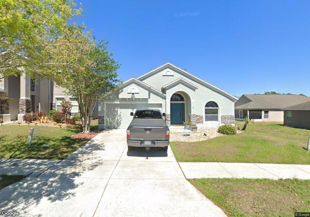
129 Dakota Ave Groveland, FL 34736
Estimated Value: $344,000 - $358,234
3
Beds
2
Baths
2,538
Sq Ft
$140/Sq Ft
Est. Value
About This Home
This home is located at 129 Dakota Ave, Groveland, FL 34736 and is currently estimated at $354,059, approximately $139 per square foot. 129 Dakota Ave is a home located in Lake County with nearby schools including Aurelia Cole Academy, South Lake High School, and THE KEY TO LEARNING.
Ownership History
Date
Name
Owned For
Owner Type
Purchase Details
Closed on
Jun 9, 2011
Sold by
Bowman Michael James and Bowman Firyuza
Bought by
Courmont Frank
Current Estimated Value
Purchase Details
Closed on
Dec 21, 2007
Sold by
Americas First Home Llp
Bought by
Bowman Michael James and Bowman Firyuza
Home Financials for this Owner
Home Financials are based on the most recent Mortgage that was taken out on this home.
Original Mortgage
$191,987
Interest Rate
6.15%
Mortgage Type
FHA
Create a Home Valuation Report for This Property
The Home Valuation Report is an in-depth analysis detailing your home's value as well as a comparison with similar homes in the area
Home Values in the Area
Average Home Value in this Area
Purchase History
| Date | Buyer | Sale Price | Title Company |
|---|---|---|---|
| Courmont Frank | $80,000 | Equitable Title Of Dr Philli | |
| Bowman Michael James | $195,000 | Patriot Home Title Co Llc |
Source: Public Records
Mortgage History
| Date | Status | Borrower | Loan Amount |
|---|---|---|---|
| Previous Owner | Bowman Michael James | $191,987 |
Source: Public Records
Tax History Compared to Growth
Tax History
| Year | Tax Paid | Tax Assessment Tax Assessment Total Assessment is a certain percentage of the fair market value that is determined by local assessors to be the total taxable value of land and additions on the property. | Land | Improvement |
|---|---|---|---|---|
| 2025 | $5,641 | $311,612 | $70,000 | $241,612 |
| 2024 | $5,641 | $311,612 | $70,000 | $241,612 |
| 2023 | $5,641 | $303,910 | $70,000 | $233,910 |
| 2022 | $5,010 | $251,512 | $52,000 | $199,512 |
| 2021 | $4,297 | $202,504 | $0 | $0 |
| 2020 | $4,038 | $187,724 | $0 | $0 |
| 2019 | $3,992 | $187,724 | $0 | $0 |
| 2018 | $3,641 | $170,666 | $0 | $0 |
| 2017 | $3,405 | $157,724 | $0 | $0 |
| 2016 | $3,194 | $134,834 | $0 | $0 |
| 2015 | $3,148 | $132,582 | $0 | $0 |
Source: Public Records
Map
Nearby Homes
- 904 Aspen View Cir
- 508 Delta Ave
- 519 Delta Ave
- 625 Silverthorn Place
- 873 Laurel View Way
- 798 Kapi Dr
- 884 Laurel View Way
- 117 Harvest Gate Blvd
- 303 Misty Haven Dr
- 946 Laurel View Way
- 945 Laurel View Way
- 234 Blackstone Creek Rd
- 309 Misty Haven Dr
- 9943 Spring Lake Dr
- 16627 Rockwell Heights Ln
- 9934 Spring Lake Dr
- Independence Plan at Hidden Ridge - Legacy Collection
- Largo Plan at Meadow Pointe - Legacy Collection
- Independence Plan at Meadow Pointe - Legacy Collection
- Marco Plan at Meadow Pointe - Legacy Collection