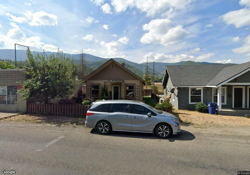
129 E Cameron Ave Kellogg, ID 83837
Estimated Value: $179,693 - $261,000
2
Beds
1
Bath
956
Sq Ft
$228/Sq Ft
Est. Value
About This Home
This home is located at 129 E Cameron Ave, Kellogg, ID 83837 and is currently estimated at $218,423, approximately $228 per square foot. 129 E Cameron Ave is a home with nearby schools including Pinehurst Elementary School, Kellogg Middle School, and Kellogg High School.
Ownership History
Date
Name
Owned For
Owner Type
Purchase Details
Closed on
Aug 25, 2025
Sold by
Patrice Ives
Bought by
E Cameron Holdings Llc
Current Estimated Value
Home Financials for this Owner
Home Financials are based on the most recent Mortgage that was taken out on this home.
Original Mortgage
$142,500
Outstanding Balance
$141,394
Interest Rate
6.75%
Mortgage Type
Seller Take Back
Estimated Equity
$77,029
Purchase Details
Closed on
Dec 20, 2022
Sold by
Ives Lance Kenneth
Bought by
Ives Twylah Patrice
Create a Home Valuation Report for This Property
The Home Valuation Report is an in-depth analysis detailing your home's value as well as a comparison with similar homes in the area
Home Values in the Area
Average Home Value in this Area
Purchase History
| Date | Buyer | Sale Price | Title Company |
|---|---|---|---|
| E Cameron Holdings Llc | -- | Flying S Title And Escrow | |
| Ives Twylah Patrice | -- | Flying S Title And Escrow | |
| Ives Twylah Patrice | -- | -- |
Source: Public Records
Mortgage History
| Date | Status | Borrower | Loan Amount |
|---|---|---|---|
| Open | E Cameron Holdings Llc | $142,500 |
Source: Public Records
Tax History
| Year | Tax Paid | Tax Assessment Tax Assessment Total Assessment is a certain percentage of the fair market value that is determined by local assessors to be the total taxable value of land and additions on the property. | Land | Improvement |
|---|---|---|---|---|
| 2025 | $42 | $172,817 | $70,228 | $102,589 |
| 2024 | $854 | $172,817 | $70,228 | $102,589 |
| 2023 | $854 | $151,072 | $64,372 | $86,700 |
| 2022 | $921 | $132,084 | $59,629 | $72,455 |
| 2021 | $875 | $88,809 | $22,941 | $65,868 |
| 2020 | $80 | $73,001 | $21,392 | $51,609 |
| 2019 | $11 | $61,210 | $17,424 | $43,786 |
| 2018 | $610 | $45,735 | $15,840 | $29,895 |
| 2017 | $567 | $42,847 | $15,840 | $27,007 |
| 2016 | $557 | $40,740 | $15,840 | $24,900 |
| 2015 | $551 | $40,740 | $15,840 | $24,900 |
| 2014 | $522 | $38,990 | $15,840 | $23,150 |
Source: Public Records
Map
Nearby Homes
- 110 Morning Star Dr Unit 345
- 150 Morning Star Dr Unit 478
- 110 Morning Star Dr Unit 244
- 110 Morning Star Dr Unit 548
- 150 Morning Star Dr Unit 181
- 150 Morning Star Dr Unit 471
- 110 Morning Star Dr Unit 152
- 4 E Mission Ave
- 202 E Market Ave
- 2 Parcels Alhambra Rd
- 457 E Market Ave
- 127 Kellogg Ave
- 124 W Idaho Ave
- 106 Kellogg Ave
- 134 W Riverside Ave
- 0 Vergobbi Unit 25-11458
- 140 Railroad Ave Unit 6
- 140 Railroad Ave Unit 5
- 140 Railroad Ave Unit 2
- 140 Railroad Ave Unit 4
- 125 & 127 E Cameron Ave
- 125 E Cameron Ave
- 121 E Cameron Ave
- 201 E Cameron Ave
- 119 E Cameron Ave
- 136 E Cameron Ave
- 130 E Cameron Ave
- 126 E Cameron Ave
- 203 E Cameron Ave
- 122 E Cameron Ave
- 122 E Cameron Ave
- 117 E Cameron Ave
- 205 E Cameron Ave
- 114 E Cameron Ave
- 113 E Cameron Ave
- 207 E Cameron Ave
- 206 E Cameron Ave
- 112 E Cameron Ave
- 209 E Cameron Ave
- 131 Riverside Ave E
Your Personal Tour Guide
Ask me questions while you tour the home.